Property Record
8300 E 123Rd St S, Bixby, OK 74008

NEARBY LISTINGS FOR SALE OR LEASE
-
-
View all Bixby listings for sale on LoopNet.com
Property Detail
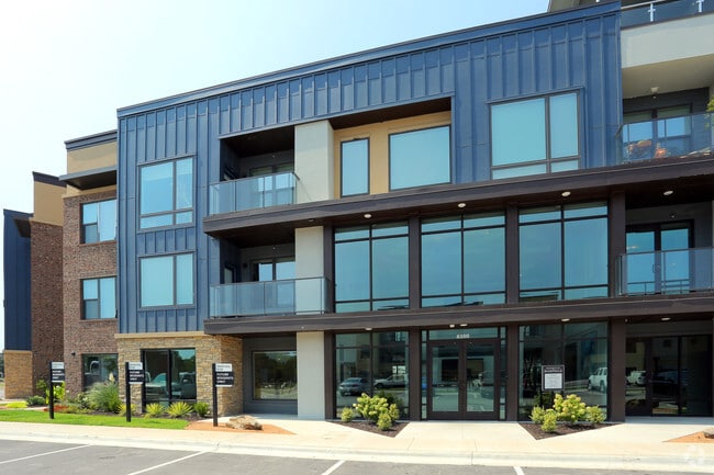
8300 E 123Rd St S
Tulsa, OK
Residences At Boardwalk (Replat Chateau
57956-73-01-20520
LOT 3 BLOCK 1
Multifamilydwelling
Tulsa
X
Oklahoma
40143C0432M
3
2025
6.97 AC
2025
South Tulsa County
007656
Tulsa
219,987 SF
DEMOGRAPHICS near 8300 E 123Rd St S
1 Mile
3 Mile
5 Mile
2024 Total Population
6,688
47,031
132,915
2029 Population
6,903
48,885
137,531
Pop Growth 2024-2029
+ 3.21%
+ 3.94%
+ 3.47%
Average Age
37
39
39
2024 Total Households
2,548
17,182
50,923
HH Growth 2024-2029
+ 2.94%
+ 3.83%
+ 3.42%
Median Household Inc
$73,683
$104,127
$90,671
Avg Household Size
2.60
2.70
2.60
2024 Avg HH Vehicles
2.00
2.00
2.00
Median Home Value
$327,572
$328,237
$269,761
Median Year Built
2002
1996
1993
Nearby Places
Map Layers
Map Styles
 Street
 Aerial
- Restaurants
- Banks
- Shops
- Fitness
- Groceries
PUBLIC TRANSPORTATION
AIRPORT
Tulsa International
DRIVE
WALK
Distance
Tulsa International
30 min
20.2 mi
Freight Ports
Tulsa Port Of Catoosa
DRIVE
WALK
Distance
Tulsa Port Of Catoosa
33 min
24.0 mi
Nearby Properties
Address
Land Use
TOTAL SIZE
Lot Size
Zoning
Address
Land Use
TOTAL SIZE
Lot Size
Zoning
390,154 SF
52.94 AC
A1
Address
Land Use
TOTAL SIZE
Lot Size
Zoning
134,232 SF
28.52 AC
R2
Address
Land Use
TOTAL SIZE
Lot Size
Zoning
55,384 SF
14.81 AC
AG
Address
Land Use
TOTAL SIZE
Lot Size
Zoning
176,243 SF
5.77 AC
CS
Address
Land Use
TOTAL SIZE
Lot Size
Zoning
152,422 SF
44.60 AC
AG
Address
Land Use
TOTAL SIZE
Lot Size
Zoning
65,385 SF
16.59 AC
AG
Address
Land Use
TOTAL SIZE
Lot Size
Zoning
33,668 SF
8.04 AC
CO
Address
Land Use
TOTAL SIZE
Lot Size
Zoning
27,278 SF
2.49 AC
CS
Address
Land Use
TOTAL SIZE
Lot Size
Zoning
98,290 SF
19.62 AC
RS3
Address
Land Use
TOTAL SIZE
Lot Size
Zoning
56,526 SF
25.18 AC
AG
Address
Land Use
TOTAL SIZE
Lot Size
Zoning
2,281,674 SF
147.83 AC
AG
Address
Land Use
TOTAL SIZE
Lot Size
Zoning
10,745 SF
56.52 AC
RS2
Address
Land Use
TOTAL SIZE
Lot Size
Zoning
30,000 SF
5.13 AC
CS
Address
Land Use
TOTAL SIZE
Lot Size
Zoning
30,000 SF
5.06 AC
Address
Land Use
TOTAL SIZE
Lot Size
Zoning
31,798 SF
4.42 AC
AG
Address
Land Use
TOTAL SIZE
Lot Size
Zoning
34,071 SF
9.29 AC
AG
Address
Land Use
TOTAL SIZE
Lot Size
Zoning
243,504 SF
13.97 AC
RM3
Address
Land Use
TOTAL SIZE
Lot Size
Zoning
10,584 SF
1.15 AC
CS
Address
Land Use
TOTAL SIZE
Lot Size
Zoning
17,776 SF
0.75 AC
CH
Address
Land Use
TOTAL SIZE
Lot Size
Zoning
295,254 SF
12.09 AC
CO
Address
Land Use
TOTAL SIZE
Lot Size
Zoning
28,174 SF
8.32 AC
AG
Address
Land Use
TOTAL SIZE
Lot Size
Zoning
27,896 SF
4.72 AC
AG
Address
Land Use
TOTAL SIZE
Lot Size
Zoning
199,720 SF
7.63 AC
RM1
Address
Land Use
TOTAL SIZE
Lot Size
Zoning
196,322 SF
23.55 AC
IM
Address
Land Use
TOTAL SIZE
Lot Size
Zoning
37,009 SF
4.18 AC
RS1
Address
Land Use
TOTAL SIZE
Lot Size
Zoning
12,156 SF
1.76 AC
CS
Address
Land Use
TOTAL SIZE
Lot Size
Zoning
58,112 SF
41.58 AC
AG
Address
Land Use
TOTAL SIZE
Lot Size
Zoning
2,500 SF
8.21 AC
RS1
Address
Land Use
TOTAL SIZE
Lot Size
Zoning
285,981 SF
68.60 AC
RM2
The World's #1 Commercial Real Estate Marketplace
Connect with us
© 2025 CoStar Group
The information above has been obtained from sources believed reliable. While we do not doubt its accuracy we have not verified it and make no guarantee, warranty or representation about it. It is your responsibility to independently confirm its accuracy and completeness. Any projections, opinions, assumptions, or estimates used are for example only and do not represent the current or future performance of the property. The value of this transaction to you depends on tax and other factors which should be evaluated by your tax, financial, and legal advisors. You and your advisors should conduct a careful, independent investigation of the property to determine to your satisfaction the suitability of the property for your needs.