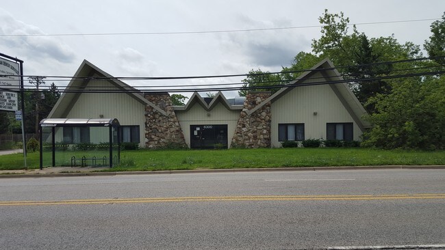
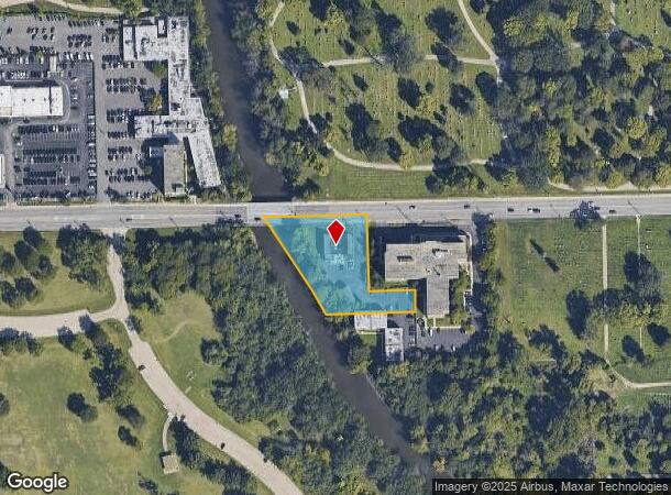
Property Record
8300 Roosevelt Rd, Forest Park, IL 60130


NEARBY LISTINGS FOR SALE OR LEASE
Property Detail
8300 Roosevelt Rd
15-23-201-004-0000
Proviso
Commercialbuilding
Cook
AE
Illinois
17031C0477J
1.46 AC
2023
Cicero/Berwyn Area
2024
Chicago
816000
Chicago-Naperville-Elgin, IL-IN-WI
4,210 SF
DEMOGRAPHICS near 8300 Roosevelt Rd
1 Mile
3 Mile
5 Mile
2024 Total Population
9,214
211,572
543,663
2029 Population
8,963
203,686
518,169
Pop Growth 2024-2029
(2.72%)
(3.73%)
(4.69%)
Average Age
42
40
39
2024 Total Households
3,677
80,326
194,770
HH Growth 2024-2029
(3.02%)
(3.88%)
(4.87%)
Median Household Inc
$44,329
$75,954
$67,799
Avg Household Size
2.40
2.50
2.70
2024 Avg HH Vehicles
1.00
2.00
2.00
Median Home Value
$215,917
$285,758
$270,518
Median Year Built
1948
1948
1949
Nearby Places
Map Layers
Map Styles
 Street
 Aerial
- Restaurants
- Banks
- Shops
- Fitness
- Groceries
PUBLIC TRANSPORTATION
COMMUTER RAIL
Maywood Station (Union Pacific West Line - Northeast Illinois Regional Commuter Railroad (Metra))
DRIVE
WALK
Distance
Maywood Station (Union Pacific West Line - Northeast Illinois Regional Commuter Railroad (Metra))
5 min
2.3 mi
River Forest Station (Union Pacific West Line - Northeast Illinois Regional Commuter Railroad (Metra))
DRIVE
WALK
Distance
River Forest Station (Union Pacific West Line - Northeast Illinois Regional Commuter Railroad (Metra))
6 min
2.5 mi
AIRPORT
Chicago Midway International
DRIVE
WALK
Distance
Chicago Midway International
17 min
8.8 mi
Chicago O'Hare International
DRIVE
WALK
Distance
Chicago O'Hare International
24 min
11.7 mi
Freight Ports
Port Milwaukee
DRIVE
WALK
Distance
Port Milwaukee
108 min
84.9 mi
Nearby Properties
Address
Land Use
TOTAL SIZE
Lot Size
Zoning
Address
Land Use
TOTAL SIZE
Lot Size
Zoning
646,763 SF
17.54 AC
Address
Land Use
TOTAL SIZE
Lot Size
Zoning
377,265 SF
25.73 AC
Address
Land Use
TOTAL SIZE
Lot Size
Zoning
233,538 SF
0.68 AC
Address
Land Use
TOTAL SIZE
Lot Size
Zoning
389,155 SF
17.69 AC
Address
Land Use
TOTAL SIZE
Lot Size
Zoning
459,659 SF
Address
Land Use
TOTAL SIZE
Lot Size
Zoning
189,908 SF
23.82 AC
Address
Land Use
TOTAL SIZE
Lot Size
Zoning
3.26 AC
Address
Land Use
TOTAL SIZE
Lot Size
Zoning
106,830 SF
1.59 AC
Address
Land Use
TOTAL SIZE
Lot Size
Zoning
108,276 SF
3.80 AC
Address
Land Use
TOTAL SIZE
Lot Size
Zoning
220,137 SF
13.24 AC
Address
Land Use
TOTAL SIZE
Lot Size
Zoning
141,800 SF
3.77 AC
Address
Land Use
TOTAL SIZE
Lot Size
Zoning
1.65 AC
Address
Land Use
TOTAL SIZE
Lot Size
Zoning
153,954 SF
14.36 AC
Address
Land Use
TOTAL SIZE
Lot Size
Zoning
101,146 SF
2.24 AC
Address
Land Use
TOTAL SIZE
Lot Size
Zoning
89,919 SF
2.87 AC
Address
Land Use
TOTAL SIZE
Lot Size
Zoning
193,511 SF
17.89 AC
Address
Land Use
TOTAL SIZE
Lot Size
Zoning
62,844 SF
3.24 AC
Address
Land Use
TOTAL SIZE
Lot Size
Zoning
120,929 SF
9 AC
Address
Land Use
TOTAL SIZE
Lot Size
Zoning
242,662 SF
21.02 AC
Address
Land Use
TOTAL SIZE
Lot Size
Zoning
150,893 SF
Address
Land Use
TOTAL SIZE
Lot Size
Zoning
Address
Land Use
TOTAL SIZE
Lot Size
Zoning
274,375 SF
9.35 AC
Address
Land Use
TOTAL SIZE
Lot Size
Zoning
1.59 AC
Address
Land Use
TOTAL SIZE
Lot Size
Zoning
7.35 AC
Address
Land Use
TOTAL SIZE
Lot Size
Zoning
7.17 AC
Address
Land Use
TOTAL SIZE
Lot Size
Zoning
296,351 SF
13.76 AC
Address
Land Use
TOTAL SIZE
Lot Size
Zoning
0.11 AC
Address
Land Use
TOTAL SIZE
Lot Size
Zoning
88,526 SF
0.76 AC
Address
Land Use
TOTAL SIZE
Lot Size
Zoning
127,528 SF
8.02 AC
Address
Land Use
TOTAL SIZE
Lot Size
Zoning
The World's #1 Commercial Real Estate Marketplace
Connect with us
© 2025 CoStar Group
The information above has been obtained from sources believed reliable. While we do not doubt its accuracy we have not verified it and make no guarantee, warranty or representation about it. It is your responsibility to independently confirm its accuracy and completeness. Any projections, opinions, assumptions, or estimates used are for example only and do not represent the current or future performance of the property. The value of this transaction to you depends on tax and other factors which should be evaluated by your tax, financial, and legal advisors. You and your advisors should conduct a careful, independent investigation of the property to determine to your satisfaction the suitability of the property for your needs.