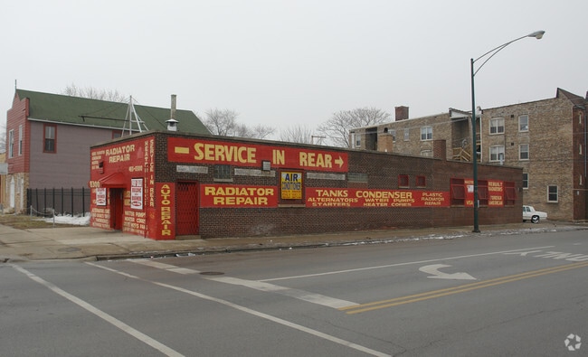
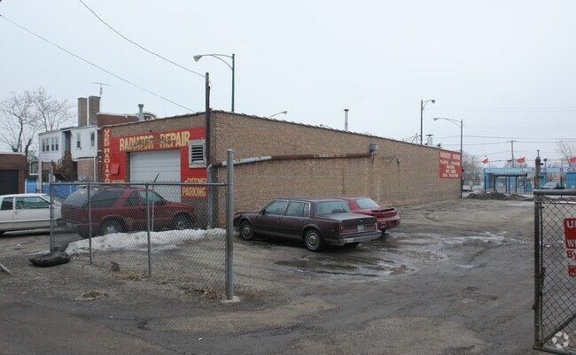
Property Record
8300 S Halsted St, Chicago, IL 60620

NEARBY LISTINGS FOR SALE OR LEASE
Property Detail
8300 S Halsted St
Chicago-Naperville-Elgin, IL-IN
Hills Sub
20-32-407-020-0000
(HILLS) SUB OF PT OF N19ACS OF PT SEC33 LYING W OF CR I&P RR OF WH SW SEC33 & N19ACS OF EH OF SE SEC 32-38-14
Commercialbuilding
Cook
X
Illinois
17031C0635J
1
2023
0.72 AC
2025
South Chicago
711000
Chicago
2,550 SF
DEMOGRAPHICS near 8300 S Halsted St
1 mile
3 mile
5 mile
2024 Total Population
28,669
242,496
697,526
2029 Population
27,414
233,759
670,934
Pop Growth 2024-2029
(4.38%)
(3.60%)
(3.81%)
Average Age
40
41
39
2024 Total Households
11,319
94,950
265,864
HH Growth 2024-2029
(4.87%)
(4.01%)
(3.95%)
Median Household Inc
$36,307
$40,632
$44,695
Avg Household Size
2.40
2.40
2.50
2024 Avg HH Vehicles
1.00
1.00
1.00
Median Home Value
$165,591
$175,732
$192,092
Median Year Built
1948
1948
1949
Nearby Places
Map Layers
Map Styles
 Street
 Aerial
Transit
 Traffic
 Biking
Places
Listings with unknown addresses are not visible on the map
- Restaurants
- Banks
- Shops
- Fitness
- Groceries
PUBLIC TRANSPORTATION
TRANSIT/SUBWAY
Gresham Station (Rock Island District Line - Northeast Illinois Regional Commuter Railroad (Metra))
Drive
Walk
Distance
Gresham Station (Rock Island District Line - Northeast Illinois Regional Commuter Railroad (Metra))
1 min
9 min
0.5 mi
COMMUTER RAIL
Gresham Station (Rock Island District Line - Northeast Illinois Regional Commuter Railroad (Metra))
Drive
Walk
Distance
Gresham Station (Rock Island District Line - Northeast Illinois Regional Commuter Railroad (Metra))
1 min
10 min
0.5 mi
Brainerd Station (Rock Island District Line - Northeast Illinois Regional Commuter Railroad (Metra))
Drive
Walk
Distance
Brainerd Station (Rock Island District Line - Northeast Illinois Regional Commuter Railroad (Metra))
4 min
1.5 mi
AIRPORT
Chicago Midway International
Drive
Walk
Distance
Chicago Midway International
18 min
9.2 mi
Chicago O'Hare International
Drive
Walk
Distance
Chicago O'Hare International
43 min
28.0 mi
SALE & LEASE HISTORY
LISTING DATE
SALE/LEASE

Nov 17, 2021
For Sale
Feb 15, 2018
For Sale
Nearby Properties
Address
Land Use
TOTAL SIZE
Lot Size
Zoning
Address
Land Use
TOTAL SIZE
Lot Size
Zoning
10.73 AC
PD 1243
Address
Land Use
TOTAL SIZE
Lot Size
Zoning
159,300 SF
13.36 AC
PD 425
Address
Land Use
TOTAL SIZE
Lot Size
Zoning
0.91 AC
PD 1177
Address
Land Use
TOTAL SIZE
Lot Size
Zoning
87,830 SF
0.76 AC
B1-1
Address
Land Use
TOTAL SIZE
Lot Size
Zoning
157,787 SF
12.23 AC
Address
Land Use
TOTAL SIZE
Lot Size
Zoning
7,200 SF
0.22 AC
B3-3
Address
Land Use
TOTAL SIZE
Lot Size
Zoning
Address
Land Use
TOTAL SIZE
Lot Size
Zoning
223,310 SF
15.67 AC
Address
Land Use
TOTAL SIZE
Lot Size
Zoning
224,089 SF
Address
Land Use
TOTAL SIZE
Lot Size
Zoning
36,365 SF
Address
Land Use
TOTAL SIZE
Lot Size
Zoning
7.47 AC
RT-4
Address
Land Use
TOTAL SIZE
Lot Size
Zoning
82,000 SF
Address
Land Use
TOTAL SIZE
Lot Size
Zoning
166,292 SF
5.95 AC
PMD13
Address
Land Use
TOTAL SIZE
Lot Size
Zoning
13,700 SF
0.33 AC
B3-2
Address
Land Use
TOTAL SIZE
Lot Size
Zoning
141,165 SF
7.82 AC
PD 966
Address
Land Use
TOTAL SIZE
Lot Size
Zoning
15,052 SF
1.03 AC
PQ
Address
Land Use
TOTAL SIZE
Lot Size
Zoning
285,672 SF
13.14 AC
Address
Land Use
TOTAL SIZE
Lot Size
Zoning
65,186 SF
10.47 AC
PD 566
Address
Land Use
TOTAL SIZE
Lot Size
Zoning
101,294 SF
8.10 AC
B3-1
Address
Land Use
TOTAL SIZE
Lot Size
Zoning
145,291 SF
7.85 AC
B3-2
Address
Land Use
TOTAL SIZE
Lot Size
Zoning
111,198 SF
10.60 AC
PD 566
Address
Land Use
TOTAL SIZE
Lot Size
Zoning
743,663 SF
7.14 AC
RT-4
Address
Land Use
TOTAL SIZE
Lot Size
Zoning
15,600 SF
0.18 AC
C2-1
Address
Land Use
TOTAL SIZE
Lot Size
Zoning
0.54 AC
RS-3
Address
Land Use
TOTAL SIZE
Lot Size
Zoning
76,867 SF
3.44 AC
M1-1
Address
Land Use
TOTAL SIZE
Lot Size
Zoning
10,500 SF
0.75 AC
C2-3
Address
Land Use
TOTAL SIZE
Lot Size
Zoning
0.39 AC
C2-3
Address
Land Use
TOTAL SIZE
Lot Size
Zoning
0.39 AC
C2-3
Address
Land Use
TOTAL SIZE
Lot Size
Zoning
0.37 AC
C2-3
Address
Land Use
TOTAL SIZE
Lot Size
Zoning
0.37 AC
C2-3
The World's #1 Commercial Real Estate Marketplace
Connect with us
© 2026 CoStar Group
The information above has been obtained from sources believed reliable. While we do not doubt its accuracy we have not verified it and make no guarantee, warranty or representation about it. It is your responsibility to independently confirm its accuracy and completeness. Any projections, opinions, assumptions, or estimates used are for example only and do not represent the current or future performance of the property. The value of this transaction to you depends on tax and other factors which should be evaluated by your tax, financial, and legal advisors. You and your advisors should conduct a careful, independent investigation of the property to determine to your satisfaction the suitability of the property for your needs.