Property Record
8300 Tewantin Dr, Houston, TX 77061


Save to a Folder
{{folder.Name}}
{{folder.ListingIds.length}} Properties
{{folder.ListingIds.length}} Property
Create a New Folder
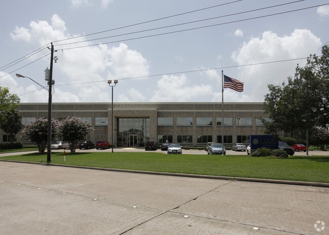
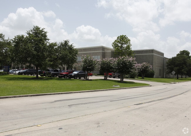
Property Detail
8300 Tewantin Dr
0971580000002
RES B BLK 11 RESTRICTED CENTRAL INDUSTRIAL PARK 3 R/P
Warehouse
HARRIS
B and X Area of moderate flood hazard, usually the area between the limits of the 100-year and 500-year floods.
Texas
2025
20 AC
2025
South Hwy 35
333700
Houston
556,568 SF
Houston-Pasadena-The Woodlands, TX
NEARBY LISTINGS FOR SALE OR LEASE
DEMOGRAPHICS near 8300 Tewantin Dr
1 mile
3 mile
5 mile
2025 Total Population
2,092
90,544
313,924
2030 Population
2,256
97,180
336,403
Pop Growth 2025-2030
+ 7.84%
+ 7.33%
+ 7.16%
Average Age
39
37
36
2025 Total Households
699
29,739
104,412
HH Growth 2025-2030
+ 7.87%
+ 7.59%
+ 7.46%
Median Household Inc
$71,177
$52,958
$53,572
Avg Household Size
2.90
3.00
2.90
2025 Avg HH Vehicles
2.00
2.00
2.00
Median Home Value
$261,082
$203,822
$202,425
Median Year Built
1956
1970
1972
Nearby Places
Map Layers
Map Styles
 Street
 Aerial
Layers
 Traffic
 Biking
Places
Listings with unknown addresses are not visible on the map
- Restaurants
- Banks
- Shops
- Fitness
- Groceries
PUBLIC TRANSPORTATION
AIRPORT
William P Hobby
Drive
Walk
Distance
William P Hobby
9 min
2.3 mi
George Bush Intcntl/Houston
Drive
Walk
Distance
George Bush Intcntl/Houston
41 min
31.1 mi
Freight Ports
Port of Houston
Drive
Walk
Distance
Port of Houston
17 min
8.5 mi
Nearby Properties
Address
Land Use
TOTAL SIZE
Lot Size
Zoning
Address
Land Use
TOTAL SIZE
Lot Size
Zoning
589,830 SF
47.20 AC
Address
Land Use
TOTAL SIZE
Lot Size
Zoning
389,108 SF
37.39 AC
Address
Land Use
TOTAL SIZE
Lot Size
Zoning
188,110 SF
2.22 AC
Address
Land Use
TOTAL SIZE
Lot Size
Zoning
196,000 SF
29.42 AC
Address
Land Use
TOTAL SIZE
Lot Size
Zoning
239,458 SF
15.57 AC
Address
Land Use
TOTAL SIZE
Lot Size
Zoning
210,476 SF
9.60 AC
Address
Land Use
TOTAL SIZE
Lot Size
Zoning
291,181 SF
11.07 AC
Address
Land Use
TOTAL SIZE
Lot Size
Zoning
391,576 SF
19.94 AC
Address
Land Use
TOTAL SIZE
Lot Size
Zoning
353,676 SF
19.86 AC
Address
Land Use
TOTAL SIZE
Lot Size
Zoning
284,290 SF
20 AC
Address
Land Use
TOTAL SIZE
Lot Size
Zoning
433,760 SF
52.70 AC
Address
Land Use
TOTAL SIZE
Lot Size
Zoning
113,688 SF
4 AC
Address
Land Use
TOTAL SIZE
Lot Size
Zoning
164,515 SF
Address
Land Use
TOTAL SIZE
Lot Size
Zoning
257,481 SF
9.28 AC
Address
Land Use
TOTAL SIZE
Lot Size
Zoning
228,900 SF
3.85 AC
Address
Land Use
TOTAL SIZE
Lot Size
Zoning
152,276 SF
6.83 AC
Address
Land Use
TOTAL SIZE
Lot Size
Zoning
165,880 SF
19.20 AC
Address
Land Use
TOTAL SIZE
Lot Size
Zoning
244,134 SF
9.44 AC
Address
Land Use
TOTAL SIZE
Lot Size
Zoning
85,323 SF
37.81 AC
Address
Land Use
TOTAL SIZE
Lot Size
Zoning
235,982 SF
9.19 AC
Address
Land Use
TOTAL SIZE
Lot Size
Zoning
418,210 SF
21.42 AC
Address
Land Use
TOTAL SIZE
Lot Size
Zoning
241,219 SF
8.92 AC
Address
Land Use
TOTAL SIZE
Lot Size
Zoning
155,657 SF
3.59 AC
Address
Land Use
TOTAL SIZE
Lot Size
Zoning
71,340 SF
47.16 AC
Address
Land Use
TOTAL SIZE
Lot Size
Zoning
215,004 SF
7.76 AC
Address
Land Use
TOTAL SIZE
Lot Size
Zoning
135,791 SF
6.98 AC
Address
Land Use
TOTAL SIZE
Lot Size
Zoning
210,628 SF
9.54 AC
Address
Land Use
TOTAL SIZE
Lot Size
Zoning
210,332 SF
11 AC
Address
Land Use
TOTAL SIZE
Lot Size
Zoning
45,038 SF
79.61 AC
The World's #1 Commercial Real Estate Marketplace
Connect with us
© 2026 CoStar Group
The information above has been obtained from sources believed reliable. While we do not doubt its accuracy we have not verified it and make no guarantee, warranty or representation about it. It is your responsibility to independently confirm its accuracy and completeness. Any projections, opinions, assumptions, or estimates used are for example only and do not represent the current or future performance of the property. The value of this transaction to you depends on tax and other factors which should be evaluated by your tax, financial, and legal advisors. You and your advisors should conduct a careful, independent investigation of the property to determine to your satisfaction the suitability of the property for your needs.