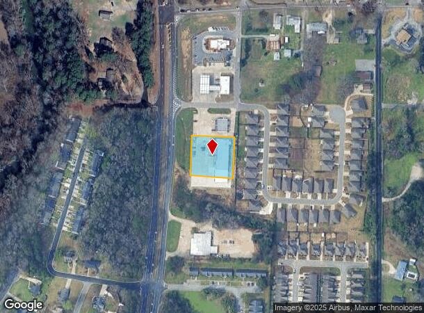
Property Record
8301 Highway 31 N, Morris, AL 35116

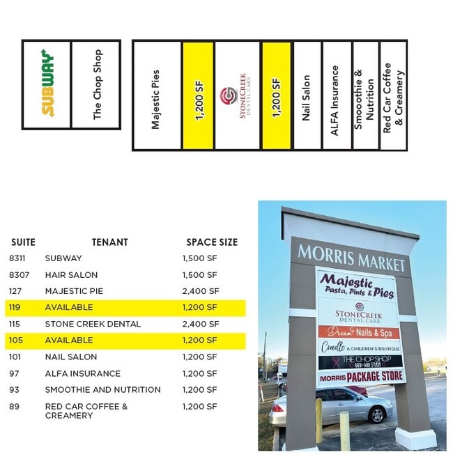
Current Lease Availabilities
NEARBY LISTINGS FOR SALE OR LEASE
-
-
View all Morris listings for lease on LoopNet.com
Property Detail
8301 Highway 31 N
Birmingham, AL
Patels Resurvey Savannah Cv C
07-00-12-3-000-019.008
LOT 2A PATELS RESURVEY SAVANNAH COVE COMMERCIAL SURVEY NO. 1 PB 246 PG 30
Storebuilding
Jefferson
X
Alabama
01073C0205H
2a
2023
0.87 AC
2024
Fultondale
011304
Birmingham
10,920 SF
DEMOGRAPHICS near 8301 Highway 31 N
1 Mile
3 Mile
5 Mile
2024 Total Population
1,503
6,420
15,062
2029 Population
1,468
6,300
14,741
Pop Growth 2024-2029
(2.33%)
(1.87%)
(2.13%)
Average Age
39
39
40
2024 Total Households
568
2,425
5,807
HH Growth 2024-2029
(2.46%)
(1.94%)
(2.15%)
Median Household Inc
$80,926
$81,831
$68,407
Avg Household Size
2.60
2.60
2.60
2024 Avg HH Vehicles
2.00
2.00
2.00
Median Home Value
$253,781
$251,584
$216,229
Median Year Built
1995
1996
1991
Nearby Places
Map Layers
Map Styles
 Street
 Aerial
- Restaurants
- Banks
- Shops
- Fitness
- Groceries
PUBLIC TRANSPORTATION
AIRPORT
Birmingham-Shuttlesworth International
DRIVE
WALK
Distance
Birmingham-Shuttlesworth International
31 min
23.5 mi
Freight Ports
Port of Mobile
DRIVE
WALK
Distance
Port of Mobile
300 min
273.3 mi
Nearby Properties
Address
Land Use
TOTAL SIZE
Lot Size
Zoning
Address
Land Use
TOTAL SIZE
Lot Size
Zoning
59,133 SF
5.80 AC
INST
Address
Land Use
TOTAL SIZE
Lot Size
Zoning
31,148 SF
46 AC
B
Address
Land Use
TOTAL SIZE
Lot Size
Zoning
74,400 SF
7 AC
I35
Address
Land Use
TOTAL SIZE
Lot Size
Zoning
34,552 SF
2.53 AC
I1
Address
Land Use
TOTAL SIZE
Lot Size
Zoning
12,900 SF
3.19 AC
Address
Land Use
TOTAL SIZE
Lot Size
Zoning
3,214 SF
0.89 AC
C2
Address
Land Use
TOTAL SIZE
Lot Size
Zoning
10,598 SF
2.18 AC
A1
Address
Land Use
TOTAL SIZE
Lot Size
Zoning
6,500 SF
1.46 AC
Address
Land Use
TOTAL SIZE
Lot Size
Zoning
3.29 AC
I
Address
Land Use
TOTAL SIZE
Lot Size
Zoning
3,240 SF
0.62 AC
C2
Address
Land Use
TOTAL SIZE
Lot Size
Zoning
1,008 SF
30 AC
C2
Address
Land Use
TOTAL SIZE
Lot Size
Zoning
12,400 SF
4.11 AC
I-1
Address
Land Use
TOTAL SIZE
Lot Size
Zoning
10,600 SF
0.85 AC
NONE
Address
Land Use
TOTAL SIZE
Lot Size
Zoning
9,024 SF
1.05 AC
I3
Address
Land Use
TOTAL SIZE
Lot Size
Zoning
46,966 SF
5.20 AC
LI
Address
Land Use
TOTAL SIZE
Lot Size
Zoning
9,090 SF
1.14 AC
A1
Address
Land Use
TOTAL SIZE
Lot Size
Zoning
8,080 SF
2 AC
NONE
Address
Land Use
TOTAL SIZE
Lot Size
Zoning
7,970 SF
4.14 AC
C1
Address
Land Use
TOTAL SIZE
Lot Size
Zoning
9,964 SF
1.40 AC
NONE
Address
Land Use
TOTAL SIZE
Lot Size
Zoning
8,006 SF
0.73 AC
I3
Address
Land Use
TOTAL SIZE
Lot Size
Zoning
6,435 SF
0.38 AC
B1
Address
Land Use
TOTAL SIZE
Lot Size
Zoning
7,800 SF
1.50 AC
I35
Address
Land Use
TOTAL SIZE
Lot Size
Zoning
10,169 SF
4.80 AC
INST
Address
Land Use
TOTAL SIZE
Lot Size
Zoning
22,325 SF
146 AC
A1
Address
Land Use
TOTAL SIZE
Lot Size
Zoning
7,476 SF
2.20 AC
NONE
Address
Land Use
TOTAL SIZE
Lot Size
Zoning
13,200 SF
2 AC
C1
Address
Land Use
TOTAL SIZE
Lot Size
Zoning
9,370 SF
0.88 AC
NONE
Address
Land Use
TOTAL SIZE
Lot Size
Zoning
187 AC
13S
The World's #1 Commercial Real Estate Marketplace
Connect with us
© 2026 CoStar Group
The information above has been obtained from sources believed reliable. While we do not doubt its accuracy we have not verified it and make no guarantee, warranty or representation about it. It is your responsibility to independently confirm its accuracy and completeness. Any projections, opinions, assumptions, or estimates used are for example only and do not represent the current or future performance of the property. The value of this transaction to you depends on tax and other factors which should be evaluated by your tax, financial, and legal advisors. You and your advisors should conduct a careful, independent investigation of the property to determine to your satisfaction the suitability of the property for your needs.