Property Record
8301 N 76Th St, Milwaukee, WI 53223


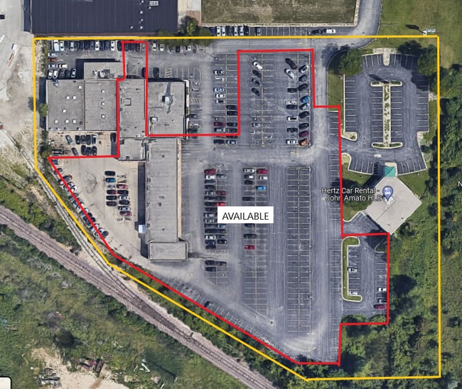
This Property Is For Sale
Current Lease Availabilities
NEARBY LISTINGS FOR SALE OR LEASE
Property Detail
8301 N 76Th St
Milwaukee-Waukesha-West Allis, WI
Cert Surv Map 4640
070-0051-100-X
CERTIFIED SURVEY MAP NO 4640 IN SE 1/4 SEC 9-8-21 LOT 1 EXC PART COM SE COR SD LOT 1-TH NWLY 580.98-TH NWLY 135.02-TH N 199.60 TO PT OF BEG-TH N 5-TH E 242.23-TH S 5-TH W 242.20 TO PT OF BEG BID #48
Vehiclerentalsvehiclesales
Milwaukee
X
Wisconsin
55089C0245G
1
2024
6.97 AC
2024
Milwaukee NW
000102
Milwaukee/Madison
40,460 SF
DEMOGRAPHICS near 8301 N 76Th St
1 Mile
3 Mile
5 Mile
2024 Total Population
4,778
59,181
172,454
2029 Population
4,631
58,052
170,794
Pop Growth 2024-2029
(3.08%)
(1.91%)
(0.96%)
Average Age
41
38
38
2024 Total Households
2,153
23,562
68,151
HH Growth 2024-2029
(3.34%)
(2.03%)
(1.00%)
Median Household Inc
$46,858
$56,580
$58,357
Avg Household Size
2.10
2.40
2.40
2024 Avg HH Vehicles
1.00
2.00
2.00
Median Home Value
$116,048
$168,284
$203,288
Median Year Built
1972
1971
1965
Nearby Places
Map Layers
Map Styles
 Street
 Aerial
- Restaurants
- Banks
- Shops
- Fitness
- Groceries
PUBLIC TRANSPORTATION
AIRPORT
General Mitchell International
DRIVE
WALK
Distance
General Mitchell International
37 min
20.8 mi
Nearby Properties
Address
Land Use
TOTAL SIZE
Lot Size
Zoning
Address
Land Use
TOTAL SIZE
Lot Size
Zoning
Address
Land Use
TOTAL SIZE
Lot Size
Zoning
33.49 AC
TL
Address
Land Use
TOTAL SIZE
Lot Size
Zoning
391,696 SF
36.33 AC
PD
Address
Land Use
TOTAL SIZE
Lot Size
Zoning
21.58 AC
RESIDENTIA
Address
Land Use
TOTAL SIZE
Lot Size
Zoning
197,426 SF
26.34 AC
PD
Address
Land Use
TOTAL SIZE
Lot Size
Zoning
206,529 SF
7.88 AC
PD
Address
Land Use
TOTAL SIZE
Lot Size
Zoning
13,717 SF
21.84 AC
IL1
Address
Land Use
TOTAL SIZE
Lot Size
Zoning
292,944 SF
17.32 AC
Address
Land Use
TOTAL SIZE
Lot Size
Zoning
245,266 SF
18.11 AC
PD
Address
Land Use
TOTAL SIZE
Lot Size
Zoning
298,666 SF
5.09 AC
PD
Address
Land Use
TOTAL SIZE
Lot Size
Zoning
Address
Land Use
TOTAL SIZE
Lot Size
Zoning
12.49 AC
TL
Address
Land Use
TOTAL SIZE
Lot Size
Zoning
104,365 SF
9.85 AC
PD
Address
Land Use
TOTAL SIZE
Lot Size
Zoning
4.70 AC
Address
Land Use
TOTAL SIZE
Lot Size
Zoning
12.70 AC
RESIDENTIA
Address
Land Use
TOTAL SIZE
Lot Size
Zoning
427 SF
35.16 AC
IL1
Address
Land Use
TOTAL SIZE
Lot Size
Zoning
4.26 AC
Address
Land Use
TOTAL SIZE
Lot Size
Zoning
419,659 SF
33.55 AC
IL1
Address
Land Use
TOTAL SIZE
Lot Size
Zoning
140,757 SF
19.08 AC
PD
Address
Land Use
TOTAL SIZE
Lot Size
Zoning
93.72 AC
PK
Address
Land Use
TOTAL SIZE
Lot Size
Zoning
25.77 AC
Address
Land Use
TOTAL SIZE
Lot Size
Zoning
Address
Land Use
TOTAL SIZE
Lot Size
Zoning
21,516 SF
11.86 AC
IL1
Address
Land Use
TOTAL SIZE
Lot Size
Zoning
364,373 SF
61.40 AC
IL1
Address
Land Use
TOTAL SIZE
Lot Size
Zoning
Address
Land Use
TOTAL SIZE
Lot Size
Zoning
1,552 SF
12.04 AC
IL1
Address
Land Use
TOTAL SIZE
Lot Size
Zoning
19.90 AC
IL1
Address
Land Use
TOTAL SIZE
Lot Size
Zoning
7,420 SF
18.06 AC
IL1
Address
Land Use
TOTAL SIZE
Lot Size
Zoning
17.91 AC
RS5
Address
Land Use
TOTAL SIZE
Lot Size
Zoning
78,920 SF
6.35 AC
The World's #1 Commercial Real Estate Marketplace
Connect with us
© 2025 CoStar Group
The information above has been obtained from sources believed reliable. While we do not doubt its accuracy we have not verified it and make no guarantee, warranty or representation about it. It is your responsibility to independently confirm its accuracy and completeness. Any projections, opinions, assumptions, or estimates used are for example only and do not represent the current or future performance of the property. The value of this transaction to you depends on tax and other factors which should be evaluated by your tax, financial, and legal advisors. You and your advisors should conduct a careful, independent investigation of the property to determine to your satisfaction the suitability of the property for your needs.