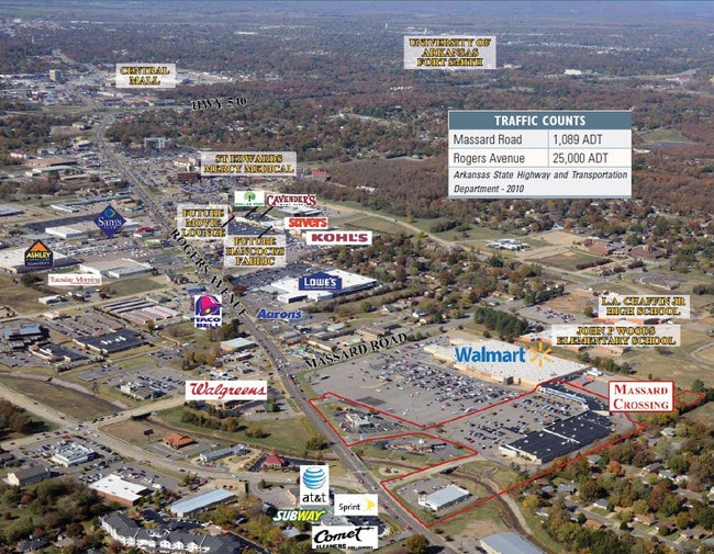
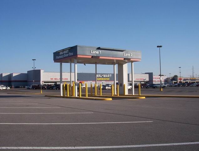
Property Record
8301 Rogers Ave, Fort Smith, AR 72903

Property Detail
8301 Rogers Ave
Fort Smith, AR-OK
LOT 1A
14943-0001-00000-00
Sebastian
Commercialnec
Arkansas
B and X Area of moderate flood hazard, usually the area between the limits of the 100-year and 500-year floods.
1a
2025
20.41 AC
2025
Greater Ft Smith
001301
Fort Smith
8,323 SF
NEARBY LISTINGS FOR SALE OR LEASE
DEMOGRAPHICS near 8301 Rogers Ave
1 mile
3 mile
5 mile
2025 Total Population
4,647
25,929
73,635
2030 Population
4,707
26,304
74,768
Pop Growth 2025-2030
+ 1.29%
+ 1.45%
+ 1.54%
Average Age
44
42
40
2025 Total Households
1,872
11,378
30,680
HH Growth 2025-2030
+ 1.23%
+ 1.43%
+ 1.55%
Median Household Inc
$86,549
$68,460
$54,194
Avg Household Size
2.30
2.20
2.30
2025 Avg HH Vehicles
2.00
2.00
2.00
Median Home Value
$257,004
$236,579
$184,680
Median Year Built
1983
1984
1976
Nearby Places
Map Layers
Map Styles
 Street
 Aerial
Layers
 Traffic
 Biking
Places
Listings with unknown addresses are not visible on the map
- Restaurants
- Banks
- Shops
- Fitness
- Groceries
PUBLIC TRANSPORTATION
AIRPORT
Fort Smith Regional
Drive
Walk
Distance
Fort Smith Regional
9 min
2.4 mi
Freight Ports
Tulsa Port of Inola
Drive
Walk
Distance
Tulsa Port of Inola
141 min
110.2 mi
Nearby Properties
Address
Land Use
TOTAL SIZE
Lot Size
Zoning
Address
Land Use
TOTAL SIZE
Lot Size
Zoning
276,870 SF
36.85 AC
Address
Land Use
TOTAL SIZE
Lot Size
Zoning
138,906 SF
9.52 AC
Address
Land Use
TOTAL SIZE
Lot Size
Zoning
97,396 SF
Address
Land Use
TOTAL SIZE
Lot Size
Zoning
21,556 SF
47 AC
Address
Land Use
TOTAL SIZE
Lot Size
Zoning
205,000 SF
30 AC
Address
Land Use
TOTAL SIZE
Lot Size
Zoning
154,181 SF
13.70 AC
Address
Land Use
TOTAL SIZE
Lot Size
Zoning
47,905 SF
27 AC
Address
Land Use
TOTAL SIZE
Lot Size
Zoning
202,092 SF
16.25 AC
Address
Land Use
TOTAL SIZE
Lot Size
Zoning
181,710 SF
14.14 AC
Address
Land Use
TOTAL SIZE
Lot Size
Zoning
340,729 SF
26.25 AC
Address
Land Use
TOTAL SIZE
Lot Size
Zoning
64,517 SF
4.09 AC
Address
Land Use
TOTAL SIZE
Lot Size
Zoning
76,575 SF
3 AC
Address
Land Use
TOTAL SIZE
Lot Size
Zoning
936,618 SF
53.06 AC
Address
Land Use
TOTAL SIZE
Lot Size
Zoning
125,968 SF
9.46 AC
Address
Land Use
TOTAL SIZE
Lot Size
Zoning
90,380 SF
9.29 AC
Address
Land Use
TOTAL SIZE
Lot Size
Zoning
72,895 SF
2.34 AC
Address
Land Use
TOTAL SIZE
Lot Size
Zoning
165,245 SF
15.39 AC
Address
Land Use
TOTAL SIZE
Lot Size
Zoning
85,229 SF
7.79 AC
Address
Land Use
TOTAL SIZE
Lot Size
Zoning
9,161 SF
13.45 AC
Address
Land Use
TOTAL SIZE
Lot Size
Zoning
18,492 SF
2.03 AC
Address
Land Use
TOTAL SIZE
Lot Size
Zoning
85,735 SF
2.28 AC
Address
Land Use
TOTAL SIZE
Lot Size
Zoning
128,006 SF
13.02 AC
Address
Land Use
TOTAL SIZE
Lot Size
Zoning
6,643 SF
0.96 AC
Address
Land Use
TOTAL SIZE
Lot Size
Zoning
100,126 SF
4.70 AC
Address
Land Use
TOTAL SIZE
Lot Size
Zoning
119,666 SF
6.90 AC
Address
Land Use
TOTAL SIZE
Lot Size
Zoning
97,142 SF
3.96 AC
Address
Land Use
TOTAL SIZE
Lot Size
Zoning
130,669 SF
8.29 AC
Address
Land Use
TOTAL SIZE
Lot Size
Zoning
55,401 SF
2.21 AC
Address
Land Use
TOTAL SIZE
Lot Size
Zoning
74,434 SF
8.63 AC
The World's #1 Commercial Real Estate Marketplace
Connect with us
© 2026 CoStar Group
The information above has been obtained from sources believed reliable. While we do not doubt its accuracy we have not verified it and make no guarantee, warranty or representation about it. It is your responsibility to independently confirm its accuracy and completeness. Any projections, opinions, assumptions, or estimates used are for example only and do not represent the current or future performance of the property. The value of this transaction to you depends on tax and other factors which should be evaluated by your tax, financial, and legal advisors. You and your advisors should conduct a careful, independent investigation of the property to determine to your satisfaction the suitability of the property for your needs.