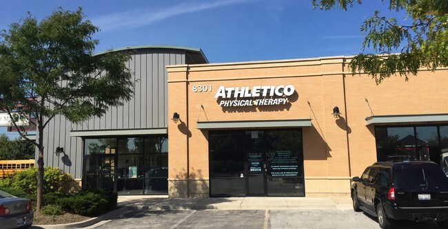
Property Record
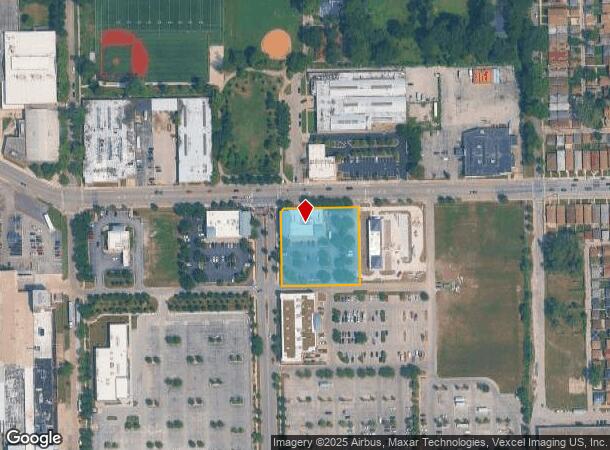
8301 S Holland Rd, Chicago, IL 60620

NEARBY LISTINGS FOR SALE OR LEASE
Property Detail
8301 S Holland Rd
20-33-412-003-0000
Chatham Market
Commercialbuilding
Cook
X
Illinois
17031C0635J
3
2023
1.06 AC
2024
South Chicago
842400
Chicago
9,910 SF
Chicago-Naperville-Elgin, IL-IN-WI
DEMOGRAPHICS near 8301 S Holland Rd
1 Mile
3 Mile
5 Mile
2024 Total Population
22,201
249,125
658,905
2029 Population
21,301
240,676
634,619
Pop Growth 2024-2029
(4.05%)
(3.39%)
(3.69%)
Average Age
41
41
39
2024 Total Households
9,154
100,025
256,761
HH Growth 2024-2029
(4.59%)
(3.82%)
(3.85%)
Median Household Inc
$42,684
$39,814
$43,492
Avg Household Size
2.30
2.40
2.40
2024 Avg HH Vehicles
1.00
1.00
1.00
Median Home Value
$184,013
$172,132
$189,146
Median Year Built
1949
1948
1949
Nearby Places
Map Layers
Map Styles
 Street
 Aerial
- Restaurants
- Banks
- Shops
- Fitness
- Groceries
PUBLIC TRANSPORTATION
TRANSIT/SUBWAY
79Th Street Station (Red Line - Chicago Transit Authority "L" Trains (The "L"))
DRIVE
WALK
Distance
79Th Street Station (Red Line - Chicago Transit Authority "L" Trains (The "L"))
4 min
15 min
0.8 mi
87Th Street Station (Red Line - Chicago Transit Authority "L" Trains (The "L"))
DRIVE
WALK
Distance
87Th Street Station (Red Line - Chicago Transit Authority "L" Trains (The "L"))
5 min
18 min
0.9 mi
COMMUTER RAIL
Gresham Station (Rock Island District Line - Northeast Illinois Regional Commuter Railroad (Metra))
DRIVE
WALK
Distance
Gresham Station (Rock Island District Line - Northeast Illinois Regional Commuter Railroad (Metra))
2 min
19 min
1.0 mi
Brainerd Station (Rock Island District Line - Northeast Illinois Regional Commuter Railroad (Metra))
DRIVE
WALK
Distance
Brainerd Station (Rock Island District Line - Northeast Illinois Regional Commuter Railroad (Metra))
5 min
2.1 mi
AIRPORT
Chicago Midway International
DRIVE
WALK
Distance
Chicago Midway International
19 min
10.0 mi
Chicago O'Hare International
DRIVE
WALK
Distance
Chicago O'Hare International
41 min
27.4 mi
Freight Ports
Port Milwaukee
DRIVE
WALK
Distance
Port Milwaukee
119 min
95.6 mi
SALE & LEASE HISTORY
LISTING DATE
SALE/LEASE

Oct 16, 2017
For Sale
Nov 27, 2017
For Sale
Nov 27, 2017
For Sale
Nov 02, 2020
For Lease
Jun 10, 2019
For Sale
Jul 02, 2018
For Sale
Jan 23, 2025
For Sale
Nearby Properties
Address
Land Use
TOTAL SIZE
Lot Size
Zoning
Address
Land Use
TOTAL SIZE
Lot Size
Zoning
10.73 AC
PD 1243
Address
Land Use
TOTAL SIZE
Lot Size
Zoning
115,000 SF
1.97 AC
C1-2
Address
Land Use
TOTAL SIZE
Lot Size
Zoning
0.91 AC
PD 1177
Address
Land Use
TOTAL SIZE
Lot Size
Zoning
159,300 SF
13.36 AC
PD 425
Address
Land Use
TOTAL SIZE
Lot Size
Zoning
87,830 SF
0.76 AC
B1-1
Address
Land Use
TOTAL SIZE
Lot Size
Zoning
115,000 SF
1.12 AC
C1-2
Address
Land Use
TOTAL SIZE
Lot Size
Zoning
7,200 SF
0.22 AC
B3-3
Address
Land Use
TOTAL SIZE
Lot Size
Zoning
622,934 SF
34.41 AC
M2-3
Address
Land Use
TOTAL SIZE
Lot Size
Zoning
7.47 AC
RT-4
Address
Land Use
TOTAL SIZE
Lot Size
Zoning
13,700 SF
0.33 AC
B3-2
Address
Land Use
TOTAL SIZE
Lot Size
Zoning
141,165 SF
7.82 AC
PD 966
Address
Land Use
TOTAL SIZE
Lot Size
Zoning
15,052 SF
1.03 AC
PQ
Address
Land Use
TOTAL SIZE
Lot Size
Zoning
101,294 SF
8.10 AC
B3-1
Address
Land Use
TOTAL SIZE
Lot Size
Zoning
145,291 SF
7.85 AC
B3-2
Address
Land Use
TOTAL SIZE
Lot Size
Zoning
111,198 SF
10.60 AC
PD 566
Address
Land Use
TOTAL SIZE
Lot Size
Zoning
743,663 SF
7.14 AC
RT-4
Address
Land Use
TOTAL SIZE
Lot Size
Zoning
15,600 SF
0.18 AC
C2-1
Address
Land Use
TOTAL SIZE
Lot Size
Zoning
0.54 AC
RS-3
Address
Land Use
TOTAL SIZE
Lot Size
Zoning
76,867 SF
3.44 AC
M1-1
Address
Land Use
TOTAL SIZE
Lot Size
Zoning
207,100 SF
9.84 AC
M2-2
Address
Land Use
TOTAL SIZE
Lot Size
Zoning
10,500 SF
0.75 AC
C2-3
Address
Land Use
TOTAL SIZE
Lot Size
Zoning
9.55 AC
M2-2
Address
Land Use
TOTAL SIZE
Lot Size
Zoning
0.39 AC
C2-3
Address
Land Use
TOTAL SIZE
Lot Size
Zoning
0.39 AC
C2-3
Address
Land Use
TOTAL SIZE
Lot Size
Zoning
0.37 AC
C2-3
Address
Land Use
TOTAL SIZE
Lot Size
Zoning
0.37 AC
C2-3
Address
Land Use
TOTAL SIZE
Lot Size
Zoning
11,700 SF
0.28 AC
B3-3
Address
Land Use
TOTAL SIZE
Lot Size
Zoning
72,219 SF
4.30 AC
M1-2
Address
Land Use
TOTAL SIZE
Lot Size
Zoning
84,400 SF
15.18 AC
M2-2,M1-1
Address
Land Use
TOTAL SIZE
Lot Size
Zoning
115,918 SF
4.08 AC
M1-2,C1-1
The World's #1 Commercial Real Estate Marketplace
Connect with us
© 2025 CoStar Group
The information above has been obtained from sources believed reliable. While we do not doubt its accuracy we have not verified it and make no guarantee, warranty or representation about it. It is your responsibility to independently confirm its accuracy and completeness. Any projections, opinions, assumptions, or estimates used are for example only and do not represent the current or future performance of the property. The value of this transaction to you depends on tax and other factors which should be evaluated by your tax, financial, and legal advisors. You and your advisors should conduct a careful, independent investigation of the property to determine to your satisfaction the suitability of the property for your needs.