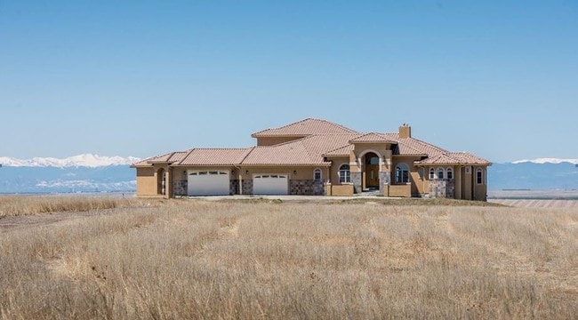
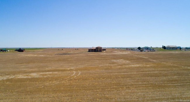
Property Record
8303 Quail Run Rd, Watkins, CO 80137

Property Detail
8303 Quail Run Rd
1727-29-4-00-001
SECT,TWN,RNG:29-2-64 DESC: PARCEL F PT OF THE SE4 OF SEC 29 DESC AS FOLS BEG AT A PT ON W LN OF SD SE4 FROM WHENCE THE N4 COR OF SD SEC 29 BRS N 00D 27M 26S W A DIST OF 2955/55 FT TH S 89D 53M 03S E AND // WITH THE N LN OF THE NE4 OF SEC 29 A DIST OF
Farms
Arapahoe
A3
Colorado
B and X Area of moderate flood hazard, usually the area between the limits of the 100-year and 500-year floods.
35.05 AC
2024
Northeast Denver
2025
Denver
008401
Denver-Aurora-Centennial, CO
9,337 SF
NEARBY LISTINGS FOR SALE OR LEASE
-
-
View all Watkins listings for sale on LoopNet.com
DEMOGRAPHICS near 8303 Quail Run Rd
1 mile
3 mile
5 mile
2025 Total Population
40
189
482
2030 Population
41
195
497
Pop Growth 2025-2030
+ 2.50%
+ 3.17%
+ 3.11%
Average Age
43
42
42
2025 Total Households
14
66
168
HH Growth 2025-2030
0.00%
+ 3.03%
+ 2.98%
Median Household Inc
$118,749
$118,749
$116,071
Avg Household Size
2.80
2.90
2.90
2025 Avg HH Vehicles
3.00
3.00
3.00
Median Home Value
$722,222
$693,750
$698,529
Median Year Built
1992
1991
1992
Nearby Places
Map Layers
Map Styles
 Street
 Aerial
Transit
 Traffic
 Biking
Places
Listings with unknown addresses are not visible on the map
- Restaurants
- Banks
- Shops
- Fitness
- Groceries
PUBLIC TRANSPORTATION
AIRPORT
Denver International
Drive
Walk
Distance
Denver International
30 min
16.4 mi
Freight Ports
Tulsa Port Of Catoosa
Drive
Walk
Distance
Tulsa Port Of Catoosa
721 min
697.1 mi
SALE & LEASE HISTORY
LISTING DATE
SALE/LEASE

May 17, 2018
For Sale
Apr 16, 2019
For Sale
Nearby Properties
Address
Land Use
TOTAL SIZE
Lot Size
Zoning
Address
Land Use
TOTAL SIZE
Lot Size
Zoning
8,832 SF
DIA
Address
Land Use
TOTAL SIZE
Lot Size
Zoning
23.70 AC
DIA
Address
Land Use
TOTAL SIZE
Lot Size
Zoning
15.88 AC
DIA
Address
Land Use
TOTAL SIZE
Lot Size
Zoning
6,928 SF
35.05 AC
A3
Address
Land Use
TOTAL SIZE
Lot Size
Zoning
8,629 SF
35.05 AC
A3
Address
Land Use
TOTAL SIZE
Lot Size
Zoning
10,007 SF
35.38 AC
A3
Address
Land Use
TOTAL SIZE
Lot Size
Zoning
3,073 SF
40.03 AC
A3
Address
Land Use
TOTAL SIZE
Lot Size
Zoning
478.01 AC
A3
Address
Land Use
TOTAL SIZE
Lot Size
Zoning
5,597 SF
35.68 AC
Address
Land Use
TOTAL SIZE
Lot Size
Zoning
7,735 SF
35.52 AC
A3
Address
Land Use
TOTAL SIZE
Lot Size
Zoning
7,999 SF
35.05 AC
A3
Address
Land Use
TOTAL SIZE
Lot Size
Zoning
7,500 SF
35.05 AC
A3
Address
Land Use
TOTAL SIZE
Lot Size
Zoning
320 AC
A3
Address
Land Use
TOTAL SIZE
Lot Size
Zoning
4,636 SF
35.05 AC
A3
Address
Land Use
TOTAL SIZE
Lot Size
Zoning
9,131 SF
40 AC
Address
Land Use
TOTAL SIZE
Lot Size
Zoning
3,880 SF
35.05 AC
A3
Address
Land Use
TOTAL SIZE
Lot Size
Zoning
6,274 SF
35 AC
A3
Address
Land Use
TOTAL SIZE
Lot Size
Zoning
5,487 SF
41.38 AC
A3
Address
Land Use
TOTAL SIZE
Lot Size
Zoning
9,054 SF
35.10 AC
A3
Address
Land Use
TOTAL SIZE
Lot Size
Zoning
5,048 SF
39.93 AC
Address
Land Use
TOTAL SIZE
Lot Size
Zoning
5,384 SF
40 AC
A3
Address
Land Use
TOTAL SIZE
Lot Size
Zoning
7,493 SF
39.55 AC
A3
Address
Land Use
TOTAL SIZE
Lot Size
Zoning
2,768 SF
127.81 AC
A3
Address
Land Use
TOTAL SIZE
Lot Size
Zoning
631.22 AC
DIA
Address
Land Use
TOTAL SIZE
Lot Size
Zoning
5,958 SF
40 AC
A3
Address
Land Use
TOTAL SIZE
Lot Size
Zoning
4,408 SF
35 AC
A3
Address
Land Use
TOTAL SIZE
Lot Size
Zoning
6,638 SF
35.05 AC
A3
Address
Land Use
TOTAL SIZE
Lot Size
Zoning
5,484 SF
39.56 AC
A3
The World's #1 Commercial Real Estate Marketplace
Connect with us
© 2026 CoStar Group
The information above has been obtained from sources believed reliable. While we do not doubt its accuracy we have not verified it and make no guarantee, warranty or representation about it. It is your responsibility to independently confirm its accuracy and completeness. Any projections, opinions, assumptions, or estimates used are for example only and do not represent the current or future performance of the property. The value of this transaction to you depends on tax and other factors which should be evaluated by your tax, financial, and legal advisors. You and your advisors should conduct a careful, independent investigation of the property to determine to your satisfaction the suitability of the property for your needs.