Property Record
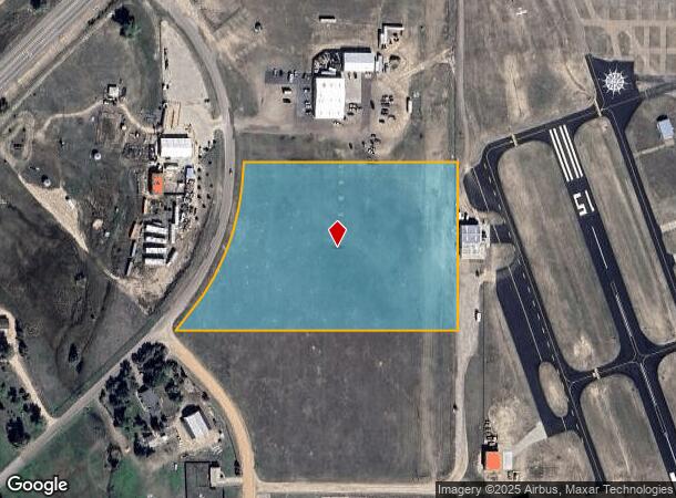
8305 Blue Gill Dr, Peyton, CO 80831
NEARBY LISTINGS FOR SALE OR LEASE
Property Detail
8305 Blue Gill Dr
Colorado Springs, CO
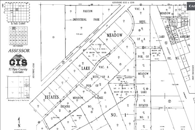
Meadow Lake Estates No 1 Refil Of Portio
43050-01-008
LOT 43A BLK 6B REFIL OF PORTION OF MEADOW LAKE ESTATES FIL 1
Commercialacreage
El Paso
X
Colorado
08041C0554G
43a
2024
6.93 AC
2025
Southeast
005123
Colorado Springs
DEMOGRAPHICS near 8305 Blue Gill Dr
1 Mile
3 Mile
5 Mile
2024 Total Population
1,214
23,009
35,436
2029 Population
1,254
24,043
37,322
Pop Growth 2024-2029
+ 3.29%
+ 4.49%
+ 5.32%
Average Age
35
35
36
2024 Total Households
388
7,105
11,250
HH Growth 2024-2029
+ 3.61%
+ 4.73%
+ 5.50%
Median Household Inc
$102,148
$122,798
$122,431
Avg Household Size
3.10
3.20
3.10
2024 Avg HH Vehicles
2.00
3.00
3.00
Median Home Value
$408,854
$440,596
$452,037
Median Year Built
2004
2007
2008
Nearby Places
Map Layers
Map Styles
 Street
 Aerial
- Restaurants
- Banks
- Shops
- Fitness
- Groceries
PUBLIC TRANSPORTATION
AIRPORT
City of Colorado Springs Municipal
DRIVE
WALK
Distance
City of Colorado Springs Municipal
25 min
13.0 mi
Freight Ports
Tulsa Port Of Catoosa
DRIVE
WALK
Distance
Tulsa Port Of Catoosa
714 min
677.2 mi
Nearby Properties
Address
Land Use
TOTAL SIZE
Lot Size
Zoning
Address
Land Use
TOTAL SIZE
Lot Size
Zoning
43,256 SF
4.49 AC
PUD
Address
Land Use
TOTAL SIZE
Lot Size
Zoning
43,256 SF
4.73 AC
Address
Land Use
TOTAL SIZE
Lot Size
Zoning
39,446 SF
10.71 AC
RR-5
Address
Land Use
TOTAL SIZE
Lot Size
Zoning
123,673 SF
9.98 AC
CR
Address
Land Use
TOTAL SIZE
Lot Size
Zoning
195,448 SF
19.86 AC
CR
Address
Land Use
TOTAL SIZE
Lot Size
Zoning
46,935 SF
13.62 AC
PUD
Address
Land Use
TOTAL SIZE
Lot Size
Zoning
16,915 SF
5.19 AC
PUD
Address
Land Use
TOTAL SIZE
Lot Size
Zoning
7,573 SF
757.70 AC
PUD R-4 R-
Address
Land Use
TOTAL SIZE
Lot Size
Zoning
16,455 SF
6.89 AC
A-35 RR-2.
Address
Land Use
TOTAL SIZE
Lot Size
Zoning
15,406 SF
5.42 AC
RR-5
Address
Land Use
TOTAL SIZE
Lot Size
Zoning
10,017 SF
1.50 AC
CR
Address
Land Use
TOTAL SIZE
Lot Size
Zoning
13,048 SF
1.63 AC
CR
Address
Land Use
TOTAL SIZE
Lot Size
Zoning
3,148 SF
0.58 AC
CR
Address
Land Use
TOTAL SIZE
Lot Size
Zoning
38,804 SF
39.37 AC
RR-5
Address
Land Use
TOTAL SIZE
Lot Size
Zoning
41,592 SF
8.59 AC
RR-5
Address
Land Use
TOTAL SIZE
Lot Size
Zoning
700 SF
53.98 AC
Address
Land Use
TOTAL SIZE
Lot Size
Zoning
6,289 SF
2.04 AC
CC
Address
Land Use
TOTAL SIZE
Lot Size
Zoning
219.19 AC
PUD
Address
Land Use
TOTAL SIZE
Lot Size
Zoning
12,111 SF
2.54 AC
PUD
Address
Land Use
TOTAL SIZE
Lot Size
Zoning
29,113 SF
3.43 AC
CR
Address
Land Use
TOTAL SIZE
Lot Size
Zoning
8,788 SF
35.90 AC
RR-5
Address
Land Use
TOTAL SIZE
Lot Size
Zoning
8,134 SF
10.19 AC
I-2
Address
Land Use
TOTAL SIZE
Lot Size
Zoning
26,235 SF
2.93 AC
CR
Address
Land Use
TOTAL SIZE
Lot Size
Zoning
85,148 SF
8.12 AC
I-2
Address
Land Use
TOTAL SIZE
Lot Size
Zoning
4,957 SF
1.77 AC
CR RS-2000
Address
Land Use
TOTAL SIZE
Lot Size
Zoning
9,901 SF
2.49 AC
CR
Address
Land Use
TOTAL SIZE
Lot Size
Zoning
22,680 SF
2.84 AC
CR
Address
Land Use
TOTAL SIZE
Lot Size
Zoning
326.51 AC
RR2
Address
Land Use
TOTAL SIZE
Lot Size
Zoning
55,980 SF
5.95 AC
CR
Address
Land Use
TOTAL SIZE
Lot Size
Zoning
160 AC
RR-5
The World's #1 Commercial Real Estate Marketplace
Connect with us
© 2026 CoStar Group
The information above has been obtained from sources believed reliable. While we do not doubt its accuracy we have not verified it and make no guarantee, warranty or representation about it. It is your responsibility to independently confirm its accuracy and completeness. Any projections, opinions, assumptions, or estimates used are for example only and do not represent the current or future performance of the property. The value of this transaction to you depends on tax and other factors which should be evaluated by your tax, financial, and legal advisors. You and your advisors should conduct a careful, independent investigation of the property to determine to your satisfaction the suitability of the property for your needs.