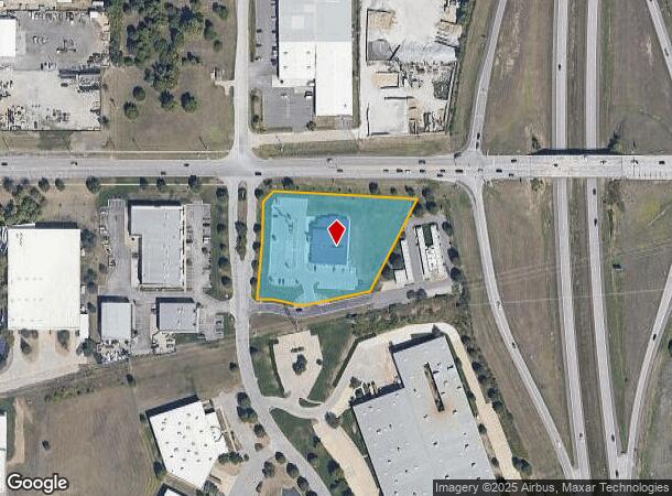
Property Record
8305 Hedge Lane Ter, Lenexa, KS 66227
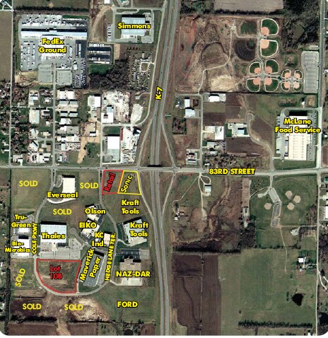
NEARBY LISTINGS FOR SALE OR LEASE
Property Detail
8305 Hedge Lane Ter
Kansas City, MO-KS
Perimeter Park First Plat
QP53100000-0015A
PERIMETER PARK EIGHTH PLAT LT 15 EX BG NE CR SE 253.85 SW 602.61 N 26.05 36.90 & 48.05 E 25.40 CUR RT 58.19 E CUR LF 76.92 NE 161.67 & 281.84 TO N/L E 96.04 TO POBSHC 486 15A
Publichealthcarefacility
Johnson
X
Kansas
20091C0032G
15
2024
2.41 AC
2024
Northwest Johnson County
052604
Kansas City
12,079 SF
DEMOGRAPHICS near 8305 Hedge Lane Ter
1 Mile
3 Mile
5 Mile
2024 Total Population
3,111
24,573
75,110
2029 Population
3,350
26,005
78,774
Pop Growth 2024-2029
+ 7.68%
+ 5.83%
+ 4.88%
Average Age
40
40
39
2024 Total Households
1,088
8,561
27,451
HH Growth 2024-2029
+ 7.90%
+ 6.00%
+ 4.94%
Median Household Inc
$134,305
$138,861
$129,008
Avg Household Size
2.80
2.80
2.70
2024 Avg HH Vehicles
2.00
2.00
2.00
Median Home Value
$401,355
$431,859
$400,048
Median Year Built
2008
2006
2003
Nearby Places
Map Layers
Map Styles
 Street
 Aerial
- Restaurants
- Banks
- Shops
- Fitness
- Groceries
PUBLIC TRANSPORTATION
AIRPORT
Kansas City International
DRIVE
WALK
Distance
Kansas City International
45 min
36.6 mi
Freight Ports
Tulsa Port Of Catoosa
DRIVE
WALK
Distance
Tulsa Port Of Catoosa
263 min
234.1 mi
Nearby Properties
Address
Land Use
TOTAL SIZE
Lot Size
Zoning
Address
Land Use
TOTAL SIZE
Lot Size
Zoning
163,515 SF
70.39 AC
R1
Address
Land Use
TOTAL SIZE
Lot Size
Zoning
106,283 SF
11.79 AC
R1
Address
Land Use
TOTAL SIZE
Lot Size
Zoning
192,548 SF
20.09 AC
BP
Address
Land Use
TOTAL SIZE
Lot Size
Zoning
91,639 SF
19.51 AC
R1
Address
Land Use
TOTAL SIZE
Lot Size
Zoning
69,675 SF
11.85 AC
R1
Address
Land Use
TOTAL SIZE
Lot Size
Zoning
32,186 SF
2.80 AC
CH
Address
Land Use
TOTAL SIZE
Lot Size
Zoning
138,758 SF
36.62 AC
BP
Address
Land Use
TOTAL SIZE
Lot Size
Zoning
100,591 SF
33.88 AC
AG
Address
Land Use
TOTAL SIZE
Lot Size
Zoning
67,336 SF
26.85 AC
AG
Address
Land Use
TOTAL SIZE
Lot Size
Zoning
42,261 SF
9.58 AC
R1
Address
Land Use
TOTAL SIZE
Lot Size
Zoning
99,600 SF
7.77 AC
PI
Address
Land Use
TOTAL SIZE
Lot Size
Zoning
75,626 SF
17.48 AC
AG
Address
Land Use
TOTAL SIZE
Lot Size
Zoning
74,420 SF
20.04 AC
AG
Address
Land Use
TOTAL SIZE
Lot Size
Zoning
73,003 SF
15.62 AC
R1
Address
Land Use
TOTAL SIZE
Lot Size
Zoning
30,751 SF
9.73 AC
R1
Address
Land Use
TOTAL SIZE
Lot Size
Zoning
24,208 SF
8.13 AC
CPO
Address
Land Use
TOTAL SIZE
Lot Size
Zoning
28,707 SF
11.92 AC
R1
Address
Land Use
TOTAL SIZE
Lot Size
Zoning
515,334 SF
58.88 AC
BP
Address
Land Use
TOTAL SIZE
Lot Size
Zoning
30.82 AC
BP
Address
Land Use
TOTAL SIZE
Lot Size
Zoning
4.93 AC
CTY RUR
Address
Land Use
TOTAL SIZE
Lot Size
Zoning
39,668 SF
6.02 AC
Address
Land Use
TOTAL SIZE
Lot Size
Zoning
32,412 SF
19.93 AC
BP
Address
Land Use
TOTAL SIZE
Lot Size
Zoning
483,724 SF
50.52 AC
BP
Address
Land Use
TOTAL SIZE
Lot Size
Zoning
24,478 SF
3.10 AC
R1
Address
Land Use
TOTAL SIZE
Lot Size
Zoning
20,832 SF
19.85 AC
AG
Address
Land Use
TOTAL SIZE
Lot Size
Zoning
13,500 SF
10.92 AC
R1
Address
Land Use
TOTAL SIZE
Lot Size
Zoning
12,746 SF
8.99 AC
AG
Address
Land Use
TOTAL SIZE
Lot Size
Zoning
19,003 SF
4.47 AC
CH
Address
Land Use
TOTAL SIZE
Lot Size
Zoning
28,390 SF
9.85 AC
AG
Address
Land Use
TOTAL SIZE
Lot Size
Zoning
16,078 SF
19.48 AC
PUDMR
The World's #1 Commercial Real Estate Marketplace
Connect with us
© 2025 CoStar Group
The information above has been obtained from sources believed reliable. While we do not doubt its accuracy we have not verified it and make no guarantee, warranty or representation about it. It is your responsibility to independently confirm its accuracy and completeness. Any projections, opinions, assumptions, or estimates used are for example only and do not represent the current or future performance of the property. The value of this transaction to you depends on tax and other factors which should be evaluated by your tax, financial, and legal advisors. You and your advisors should conduct a careful, independent investigation of the property to determine to your satisfaction the suitability of the property for your needs.