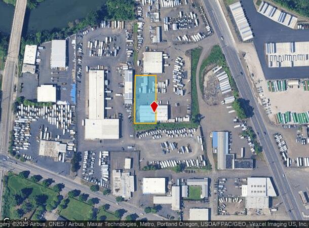
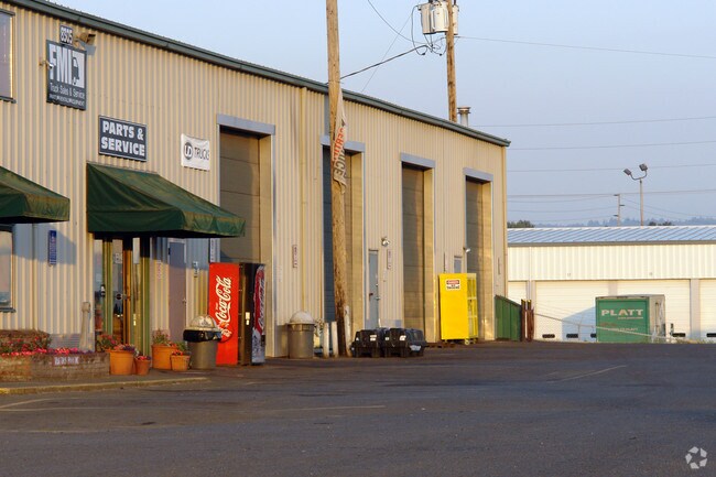
Property Record
8305 Ne M L King Blvd, Portland, OR 97211

NEARBY LISTINGS FOR SALE OR LEASE
Property Detail
8305 Ne M L King Blvd
R209426
Loves Add
Industrialgeneral
LOVES ADD, BLOCK B EXC N 141
ARE
Multnomah
41067C0400E
Oregon
2025
0.68 AC
2025
Airport Way
007202
Portland
14,000 SF
Portland-Vancouver-Hillsboro, OR-WA
DEMOGRAPHICS near 8305 Ne M L King Blvd
1 Mile
3 Mile
5 Mile
2024 Total Population
9,971
103,955
321,220
2029 Population
9,778
102,468
322,282
Pop Growth 2024-2029
(1.94%)
(1.43%)
+ 0.33%
Average Age
40
39
40
2024 Total Households
4,122
43,817
151,306
HH Growth 2024-2029
(2.21%)
(1.39%)
+ 0.29%
Median Household Inc
$75,909
$93,668
$78,111
Avg Household Size
2.20
2.20
2.00
2024 Avg HH Vehicles
2.00
2.00
1.00
Median Home Value
$486,012
$592,538
$581,323
Median Year Built
1949
1949
1962
Nearby Places
Map Layers
Map Styles
 Street
 Aerial
- Restaurants
- Banks
- Shops
- Fitness
- Groceries
PUBLIC TRANSPORTATION
COMMUTER RAIL
DRIVE
WALK
Distance
11 min
5.5 mi
DRIVE
WALK
Distance
13 min
5.6 mi
AIRPORT
Portland International
DRIVE
WALK
Distance
Portland International
16 min
6.6 mi
Freight Ports
Port of Portland
DRIVE
WALK
Distance
Port of Portland
12 min
6.2 mi
Nearby Properties
Address
Land Use
TOTAL SIZE
Lot Size
Zoning
Address
Land Use
TOTAL SIZE
Lot Size
Zoning
200,109 SF
70.44 AC
IH
Address
Land Use
TOTAL SIZE
Lot Size
Zoning
395,815 SF
2.66 AC
IRD
Address
Land Use
TOTAL SIZE
Lot Size
Zoning
15,473 SF
192.67 AC
IG2
Address
Land Use
TOTAL SIZE
Lot Size
Zoning
522,778 SF
193.16 AC
CPX
Address
Land Use
TOTAL SIZE
Lot Size
Zoning
437,419 SF
37.90 AC
IG2
Address
Land Use
TOTAL SIZE
Lot Size
Zoning
465,188 SF
1.29 AC
CX
Address
Land Use
TOTAL SIZE
Lot Size
Zoning
Address
Land Use
TOTAL SIZE
Lot Size
Zoning
243,371 SF
0.67 AC
CI2
Address
Land Use
TOTAL SIZE
Lot Size
Zoning
645,294 SF
5.64 AC
CO2D
Address
Land Use
TOTAL SIZE
Lot Size
Zoning
490,802 SF
56.17 AC
CGX
Address
Land Use
TOTAL SIZE
Lot Size
Zoning
193,898 SF
2.50 AC
IRD
Address
Land Use
TOTAL SIZE
Lot Size
Zoning
134,398 SF
3.17 AC
CG
Address
Land Use
TOTAL SIZE
Lot Size
Zoning
1,660,710 SF
110.33 AC
IG2
Address
Land Use
TOTAL SIZE
Lot Size
Zoning
537,280 SF
NULL
Address
Land Use
TOTAL SIZE
Lot Size
Zoning
85,000 SF
1.65 AC
CI2
Address
Land Use
TOTAL SIZE
Lot Size
Zoning
278,788 SF
0.92 AC
CX
Address
Land Use
TOTAL SIZE
Lot Size
Zoning
97,000 SF
NULL
Address
Land Use
TOTAL SIZE
Lot Size
Zoning
107,958 SF
2.48 AC
IG2
Address
Land Use
TOTAL SIZE
Lot Size
Zoning
294,114 SF
2.03 AC
CX
Address
Land Use
TOTAL SIZE
Lot Size
Zoning
40,595 SF
1.99 AC
IRD
Address
Land Use
TOTAL SIZE
Lot Size
Zoning
18,135 SF
0.45 AC
CX
Address
Land Use
TOTAL SIZE
Lot Size
Zoning
11,375 SF
1.46 AC
CI2
Address
Land Use
TOTAL SIZE
Lot Size
Zoning
133.11 AC
IG2
Address
Land Use
TOTAL SIZE
Lot Size
Zoning
1,256 SF
103.58 AC
IG2
Address
Land Use
TOTAL SIZE
Lot Size
Zoning
8.01 AC
EG2
Address
Land Use
TOTAL SIZE
Lot Size
Zoning
112,578 SF
2.94 AC
CI2
Address
Land Use
TOTAL SIZE
Lot Size
Zoning
127,050 SF
1.23 AC
CX
Address
Land Use
TOTAL SIZE
Lot Size
Zoning
118,469 SF
47.45 AC
IG2
Address
Land Use
TOTAL SIZE
Lot Size
Zoning
62,100 SF
4.50 AC
OS
Address
Land Use
TOTAL SIZE
Lot Size
Zoning
303,097 SF
1.46 AC
IRD
The World's #1 Commercial Real Estate Marketplace
Connect with us
© 2025 CoStar Group
The information above has been obtained from sources believed reliable. While we do not doubt its accuracy we have not verified it and make no guarantee, warranty or representation about it. It is your responsibility to independently confirm its accuracy and completeness. Any projections, opinions, assumptions, or estimates used are for example only and do not represent the current or future performance of the property. The value of this transaction to you depends on tax and other factors which should be evaluated by your tax, financial, and legal advisors. You and your advisors should conduct a careful, independent investigation of the property to determine to your satisfaction the suitability of the property for your needs.