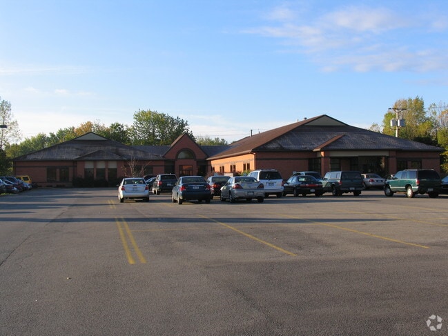
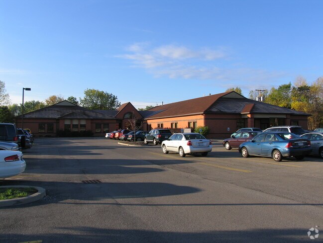
Property Record
831 Maple Rd, Buffalo, NY 14221
NEARBY LISTINGS FOR SALE OR LEASE
Property Detail
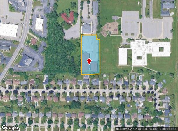
831 Maple Rd
Buffalo-Cheektowaga, NY
Holland Land Companys Survey
142289-055-200-0001-001-110
60 12 7
Officebuilding
Erie
X
New York
36029C0207H
1.110
2025
1.59 AC
2024
North
009104
Buffalo/Niagara Falls
18,160 SF
DEMOGRAPHICS near 831 Maple Rd
1 Mile
3 Mile
5 Mile
2024 Total Population
9,777
95,625
248,883
2029 Population
9,853
95,854
247,676
Pop Growth 2024-2029
+ 0.78%
+ 0.24%
(0.48%)
Average Age
44
42
41
2024 Total Households
3,956
37,450
102,422
HH Growth 2024-2029
+ 0.88%
+ 0.34%
(0.51%)
Median Household Inc
$97,082
$84,905
$71,045
Avg Household Size
2.40
2.30
2.30
2024 Avg HH Vehicles
2.00
2.00
2.00
Median Home Value
$267,090
$264,012
$214,363
Median Year Built
1967
1970
1961
Nearby Places
Map Layers
Map Styles
 Street
 Aerial
- Restaurants
- Banks
- Shops
- Fitness
- Groceries
PUBLIC TRANSPORTATION
COMMUTER RAIL
DRIVE
WALK
Distance
17 min
7.1 mi
DRIVE
WALK
Distance
16 min
7.2 mi
AIRPORT
Buffalo Niagara International
DRIVE
WALK
Distance
Buffalo Niagara International
12 min
4.5 mi
Niagara Falls International
DRIVE
WALK
Distance
Niagara Falls International
27 min
14.2 mi
SALE & LEASE HISTORY
LISTING DATE
SALE/LEASE

Sep 24, 2019
For Lease
Sep 24, 2016
For Sale
Sep 12, 2017
For Sale
Jul 26, 2017
For Lease
Jan 26, 2017
For Sale
Apr 12, 2017
For Sale
Nearby Properties
Address
Land Use
TOTAL SIZE
Lot Size
Zoning
Address
Land Use
TOTAL SIZE
Lot Size
Zoning
2,592,064 SF
1,057.90 AC
Address
Land Use
TOTAL SIZE
Lot Size
Zoning
109,328 SF
12.77 AC
GB
Address
Land Use
TOTAL SIZE
Lot Size
Zoning
308,191 SF
19.74 AC
CF
Address
Land Use
TOTAL SIZE
Lot Size
Zoning
132,940 SF
41.50 AC
CF
Address
Land Use
TOTAL SIZE
Lot Size
Zoning
Address
Land Use
TOTAL SIZE
Lot Size
Zoning
283,706 SF
68.90 AC
Address
Land Use
TOTAL SIZE
Lot Size
Zoning
177,000 SF
14.91 AC
CF
Address
Land Use
TOTAL SIZE
Lot Size
Zoning
41,104 SF
27.52 AC
Address
Land Use
TOTAL SIZE
Lot Size
Zoning
322,151 SF
44.99 AC
Address
Land Use
TOTAL SIZE
Lot Size
Zoning
2,592 SF
22.75 AC
NCD
Address
Land Use
TOTAL SIZE
Lot Size
Zoning
16,065 SF
19.75 AC
Address
Land Use
TOTAL SIZE
Lot Size
Zoning
8,565 SF
22.65 AC
Address
Land Use
TOTAL SIZE
Lot Size
Zoning
24,600 SF
19.20 AC
00000
Address
Land Use
TOTAL SIZE
Lot Size
Zoning
12,262 SF
29 AC
MFR-5
Address
Land Use
TOTAL SIZE
Lot Size
Zoning
172,400 SF
116.50 AC
Address
Land Use
TOTAL SIZE
Lot Size
Zoning
260,326 SF
22.70 AC
Address
Land Use
TOTAL SIZE
Lot Size
Zoning
203,546 SF
13.55 AC
Address
Land Use
TOTAL SIZE
Lot Size
Zoning
213,943 SF
5.50 AC
Address
Land Use
TOTAL SIZE
Lot Size
Zoning
181,897 SF
15.30 AC
CTR-2.5
Address
Land Use
TOTAL SIZE
Lot Size
Zoning
2,173 SF
15.33 AC
Address
Land Use
TOTAL SIZE
Lot Size
Zoning
8,842 SF
29.30 AC
Address
Land Use
TOTAL SIZE
Lot Size
Zoning
Address
Land Use
TOTAL SIZE
Lot Size
Zoning
71,053 SF
2.52 AC
OB
Address
Land Use
TOTAL SIZE
Lot Size
Zoning
8,296 SF
16.60 AC
Address
Land Use
TOTAL SIZE
Lot Size
Zoning
172,001 SF
23.49 AC
Address
Land Use
TOTAL SIZE
Lot Size
Zoning
Address
Land Use
TOTAL SIZE
Lot Size
Zoning
3,630 SF
10.50 AC
Address
Land Use
TOTAL SIZE
Lot Size
Zoning
7,744 SF
17.82 AC
Address
Land Use
TOTAL SIZE
Lot Size
Zoning
403,248 SF
53.50 AC
Address
Land Use
TOTAL SIZE
Lot Size
Zoning
54,109 SF
6.19 AC
OB
The World's #1 Commercial Real Estate Marketplace
Connect with us
© 2026 CoStar Group
The information above has been obtained from sources believed reliable. While we do not doubt its accuracy we have not verified it and make no guarantee, warranty or representation about it. It is your responsibility to independently confirm its accuracy and completeness. Any projections, opinions, assumptions, or estimates used are for example only and do not represent the current or future performance of the property. The value of this transaction to you depends on tax and other factors which should be evaluated by your tax, financial, and legal advisors. You and your advisors should conduct a careful, independent investigation of the property to determine to your satisfaction the suitability of the property for your needs.