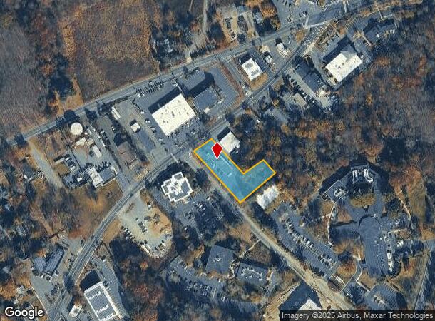
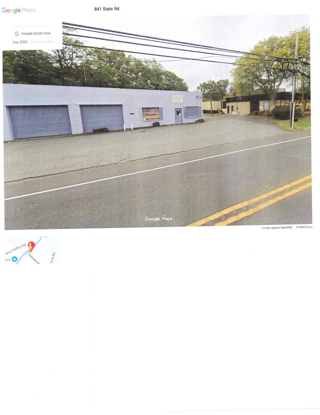
Property Record
831 State Rd, Princeton, NJ 08540

This Property Is For Sale
Current Lease Availabilities
NEARBY LISTINGS FOR SALE OR LEASE
Property Detail
831 State Rd
Trenton-Princeton, NJ
B-41,L-46
14-00902-0000-00002
Mercer
Commercialnec
New Jersey
AE
2
34035C0244F
0.83 AC
2024
Princeton
2025
Northern New Jersey
004000
DEMOGRAPHICS near 831 State Rd
1 mile
3 mile
5 mile
2024 Total Population
5,854
32,596
74,843
2029 Population
5,801
32,526
74,862
Pop Growth 2024-2029
(0.91%)
(0.21%)
+ 0.03%
Average Age
43
42
42
2024 Total Households
2,261
12,249
26,470
HH Growth 2024-2029
(1.06%)
(0.39%)
+ 0.06%
Median Household Inc
$135,786
$165,834
$171,597
Avg Household Size
2.50
2.50
2.70
2024 Avg HH Vehicles
2.00
2.00
2.00
Median Home Value
$562,312
$746,497
$727,249
Median Year Built
1992
1982
1986
Nearby Places
Map Layers
Map Styles
 Street
 Aerial
Transit
 Traffic
 Biking
Places
Listings with unknown addresses are not visible on the map
- Restaurants
- Banks
- Shops
- Fitness
- Groceries
PUBLIC TRANSPORTATION
COMMUTER RAIL
Princeton (Princeton Branch - NJ Transit Commuter Rail (NJ Transit))
Drive
Walk
Distance
Princeton (Princeton Branch - NJ Transit Commuter Rail (NJ Transit))
8 min
3.6 mi
Princeton Junction (Northeast Corridor Line - NJ Transit Commuter Rail (NJ Transit), Princeton Branch - NJ Transit Commuter Rail (NJ Transit))
Drive
Walk
Distance
Princeton Junction (Northeast Corridor Line - NJ Transit Commuter Rail (NJ Transit), Princeton Branch - NJ Transit Commuter Rail (NJ Transit))
14 min
6.2 mi
AIRPORT
Trenton Mercer
Drive
Walk
Distance
Trenton Mercer
28 min
15.2 mi
Newark Liberty International
Drive
Walk
Distance
Newark Liberty International
59 min
42.2 mi
Freight Ports
New York Container Terminal
Drive
Walk
Distance
New York Container Terminal
53 min
35.0 mi
Nearby Properties
Address
Land Use
TOTAL SIZE
Lot Size
Zoning
Address
Land Use
TOTAL SIZE
Lot Size
Zoning
23.64 AC
PMUD
Address
Land Use
TOTAL SIZE
Lot Size
Zoning
8.97 AC
HMC
Address
Land Use
TOTAL SIZE
Lot Size
Zoning
115,000 SF
7.98 AC
OR2
Address
Land Use
TOTAL SIZE
Lot Size
Zoning
405,811 SF
4.14 AC
Address
Land Use
TOTAL SIZE
Lot Size
Zoning
216,000 SF
22.79 AC
SC
Address
Land Use
TOTAL SIZE
Lot Size
Zoning
Address
Land Use
TOTAL SIZE
Lot Size
Zoning
2.49 AC
E3
Address
Land Use
TOTAL SIZE
Lot Size
Zoning
2.29 AC
Address
Land Use
TOTAL SIZE
Lot Size
Zoning
21.79 AC
R3
Address
Land Use
TOTAL SIZE
Lot Size
Zoning
52,000 SF
0.62 AC
CBCP
Address
Land Use
TOTAL SIZE
Lot Size
Zoning
167,546 SF
3.08 AC
Address
Land Use
TOTAL SIZE
Lot Size
Zoning
36.45 AC
E4
Address
Land Use
TOTAL SIZE
Lot Size
Zoning
0.26 AC
OR2
Address
Land Use
TOTAL SIZE
Lot Size
Zoning
4.44 AC
Address
Land Use
TOTAL SIZE
Lot Size
Zoning
72,000 SF
0.09 AC
CB
Address
Land Use
TOTAL SIZE
Lot Size
Zoning
86,765 SF
2.07 AC
E2
Address
Land Use
TOTAL SIZE
Lot Size
Zoning
30 AC
E4
Address
Land Use
TOTAL SIZE
Lot Size
Zoning
30.02 AC
OB-1
Address
Land Use
TOTAL SIZE
Lot Size
Zoning
72,988 SF
1.51 AC
Address
Land Use
TOTAL SIZE
Lot Size
Zoning
345.28 AC
M3
Address
Land Use
TOTAL SIZE
Lot Size
Zoning
6.71 AC
PMUD
Address
Land Use
TOTAL SIZE
Lot Size
Zoning
4.39 AC
Address
Land Use
TOTAL SIZE
Lot Size
Zoning
27.04 AC
R1
Address
Land Use
TOTAL SIZE
Lot Size
Zoning
35.71 AC
OR1
Address
Land Use
TOTAL SIZE
Lot Size
Zoning
88,479 SF
2.42 AC
Address
Land Use
TOTAL SIZE
Lot Size
Zoning
10 AC
OR1
Address
Land Use
TOTAL SIZE
Lot Size
Zoning
103,199 SF
1.21 AC
E4
Address
Land Use
TOTAL SIZE
Lot Size
Zoning
17.45 AC
HC
Address
Land Use
TOTAL SIZE
Lot Size
Zoning
69,239 SF
1.33 AC
E2
Address
Land Use
TOTAL SIZE
Lot Size
Zoning
29,088 SF
1.06 AC
The World's #1 Commercial Real Estate Marketplace
Connect with us
© 2026 CoStar Group
The information above has been obtained from sources believed reliable. While we do not doubt its accuracy we have not verified it and make no guarantee, warranty or representation about it. It is your responsibility to independently confirm its accuracy and completeness. Any projections, opinions, assumptions, or estimates used are for example only and do not represent the current or future performance of the property. The value of this transaction to you depends on tax and other factors which should be evaluated by your tax, financial, and legal advisors. You and your advisors should conduct a careful, independent investigation of the property to determine to your satisfaction the suitability of the property for your needs.