Property Record
831 Straits Tpke, Watertown, CT 06795
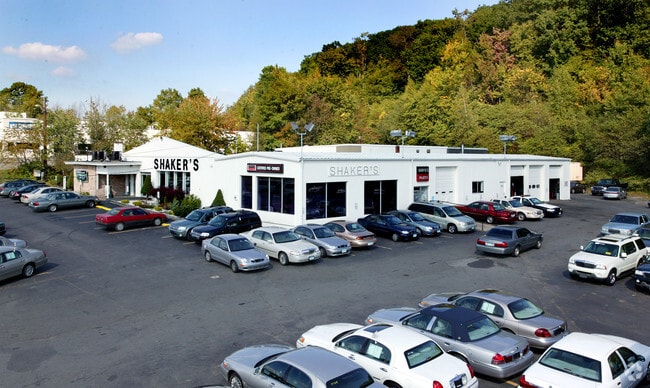

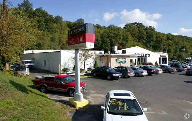
Property Detail
831 Straits Tpke
WATE-000165A-000257-000053
Naugatuck Vly
Vehiclerentalsvehiclesales
Connecticut
BSC
53
B and X Area of moderate flood hazard, usually the area between the limits of the 100-year and 500-year floods.
2.29 AC
2025
SE Litchfield County
2025
Hartford
360400
Torrington, CT
30,289 SF
NEARBY LISTINGS FOR SALE OR LEASE
DEMOGRAPHICS near 831 Straits Tpke
1 mile
3 mile
5 mile
2025 Total Population
4,366
54,750
132,198
2030 Population
4,519
56,167
135,511
Pop Growth 2025-2030
+ 3.50%
+ 2.59%
+ 2.51%
Average Age
44
40
40
2025 Total Households
1,638
21,017
51,318
HH Growth 2025-2030
+ 3.66%
+ 2.64%
+ 2.58%
Median Household Inc
$91,473
$72,964
$61,939
Avg Household Size
2.50
2.50
2.50
2025 Avg HH Vehicles
2.00
2.00
2.00
Median Home Value
$293,955
$272,224
$255,932
Median Year Built
1968
1960
1959
Nearby Places
Map Layers
Map Styles
 Street
 Aerial
Layers
 Traffic
 Biking
Places
Listings with unknown addresses are not visible on the map
- Restaurants
- Banks
- Shops
- Fitness
- Groceries
PUBLIC TRANSPORTATION
COMMUTER RAIL
Waterbury Station (New Haven Line - Metro-North Commuter Railroad Company (Metro-North))
Drive
Walk
Distance
Waterbury Station (New Haven Line - Metro-North Commuter Railroad Company (Metro-North))
8 min
4.2 mi
Naugatuck Station (New Haven Line - Metro-North Commuter Railroad Company (Metro-North))
Drive
Walk
Distance
Naugatuck Station (New Haven Line - Metro-North Commuter Railroad Company (Metro-North))
10 min
6.2 mi
AIRPORT
Tweed/New Haven
Drive
Walk
Distance
Tweed/New Haven
48 min
29.7 mi
Freight Ports
Port of New Haven
Drive
Walk
Distance
Port of New Haven
43 min
26.8 mi
Nearby Properties
Address
Land Use
TOTAL SIZE
Lot Size
Zoning
Address
Land Use
TOTAL SIZE
Lot Size
Zoning
196,057 SF
17 AC
RS
Address
Land Use
TOTAL SIZE
Lot Size
Zoning
16.10 AC
CO
Address
Land Use
TOTAL SIZE
Lot Size
Zoning
75 AC
R20
Address
Land Use
TOTAL SIZE
Lot Size
Zoning
156,279 SF
12.13 AC
RL
Address
Land Use
TOTAL SIZE
Lot Size
Zoning
1.86 AC
CBD
Address
Land Use
TOTAL SIZE
Lot Size
Zoning
182,949 SF
9.10 AC
RS
Address
Land Use
TOTAL SIZE
Lot Size
Zoning
155,861 SF
13.70 AC
R125
Address
Land Use
TOTAL SIZE
Lot Size
Zoning
201,817 SF
34.84 AC
R125
Address
Land Use
TOTAL SIZE
Lot Size
Zoning
70,857 SF
1.71 AC
CBD
Address
Land Use
TOTAL SIZE
Lot Size
Zoning
140,700 SF
25.55 AC
R30
Address
Land Use
TOTAL SIZE
Lot Size
Zoning
129,672 SF
8 AC
IG
Address
Land Use
TOTAL SIZE
Lot Size
Zoning
36.10 AC
RS
Address
Land Use
TOTAL SIZE
Lot Size
Zoning
76,264 SF
15.03 AC
RS
Address
Land Use
TOTAL SIZE
Lot Size
Zoning
49,768 SF
4.35 AC
CO
Address
Land Use
TOTAL SIZE
Lot Size
Zoning
54,580 SF
0.65 AC
CBD
Address
Land Use
TOTAL SIZE
Lot Size
Zoning
26.40 AC
RS-12
Address
Land Use
TOTAL SIZE
Lot Size
Zoning
74,579 SF
1.02 AC
CBD
Address
Land Use
TOTAL SIZE
Lot Size
Zoning
30.46 AC
RM
Address
Land Use
TOTAL SIZE
Lot Size
Zoning
72,336 SF
15.39 AC
R30
Address
Land Use
TOTAL SIZE
Lot Size
Zoning
5 AC
RO
Address
Land Use
TOTAL SIZE
Lot Size
Zoning
24.60 AC
RM
Address
Land Use
TOTAL SIZE
Lot Size
Zoning
54,820 SF
1.03 AC
CA
Address
Land Use
TOTAL SIZE
Lot Size
Zoning
209.81 AC
R125
Address
Land Use
TOTAL SIZE
Lot Size
Zoning
1.24 AC
RM
Address
Land Use
TOTAL SIZE
Lot Size
Zoning
84,480 SF
11.06 AC
BSC
Address
Land Use
TOTAL SIZE
Lot Size
Zoning
65,790 SF
1.30 AC
CBD
Address
Land Use
TOTAL SIZE
Lot Size
Zoning
180,169 SF
3.64 AC
RM
Address
Land Use
TOTAL SIZE
Lot Size
Zoning
53,668 SF
5.14 AC
CO
Address
Land Use
TOTAL SIZE
Lot Size
Zoning
78,530 SF
20.98 AC
BSC
Address
Land Use
TOTAL SIZE
Lot Size
Zoning
12.45 AC
RM
The World's #1 Commercial Real Estate Marketplace
Connect with us
© 2026 CoStar Group
The information above has been obtained from sources believed reliable. While we do not doubt its accuracy we have not verified it and make no guarantee, warranty or representation about it. It is your responsibility to independently confirm its accuracy and completeness. Any projections, opinions, assumptions, or estimates used are for example only and do not represent the current or future performance of the property. The value of this transaction to you depends on tax and other factors which should be evaluated by your tax, financial, and legal advisors. You and your advisors should conduct a careful, independent investigation of the property to determine to your satisfaction the suitability of the property for your needs.