Property Record
831 Us Highway 85, Nunn, CO 80648
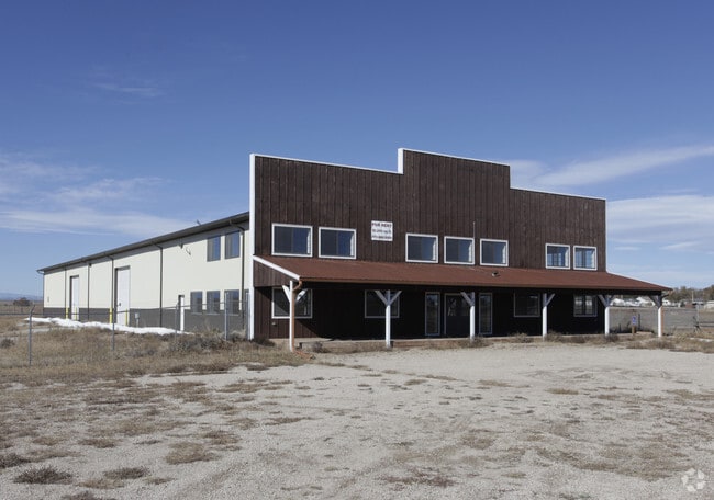

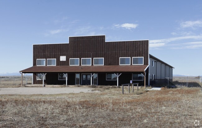
Property Detail
831 Us Highway 85
Greeley, CO
NUN DTM L2 BLK 1 DOUBLETREE MINOR
R4398706
Weld
Commercialnec
Colorado
B and X Area of moderate flood hazard, usually the area between the limits of the 100-year and 500-year floods.
2
2024
4.55 AC
2025
Weld County
002501
Denver
16,228 SF
NEARBY LISTINGS FOR SALE OR LEASE
DEMOGRAPHICS near 831 Us Highway 85
1 mile
3 mile
5 mile
2025 Total Population
577
974
2,512
2030 Population
632
1,066
2,716
Pop Growth 2025-2030
+ 9.53%
+ 9.45%
+ 8.12%
Average Age
41
41
40
2025 Total Households
233
379
942
HH Growth 2025-2030
+ 9.87%
+ 9.76%
+ 8.49%
Median Household Inc
$88,571
$89,516
$81,465
Avg Household Size
2.50
2.50
2.60
2025 Avg HH Vehicles
3.00
3.00
3.00
Median Home Value
$361,578
$390,869
$397,631
Median Year Built
1970
1980
1979
Nearby Places
Map Layers
Map Styles
 Street
 Aerial
Layers
 Traffic
 Biking
Places
Listings with unknown addresses are not visible on the map
- Restaurants
- Banks
- Shops
- Fitness
- Groceries
SALE & LEASE HISTORY
LISTING DATE
SALE/LEASE

Sep 25, 2016
For Lease
Sep 24, 2016
For Sale
Nearby Properties
Address
Land Use
TOTAL SIZE
Lot Size
Zoning
Address
Land Use
TOTAL SIZE
Lot Size
Zoning
35,000 SF
3.51 AC
Address
Land Use
TOTAL SIZE
Lot Size
Zoning
12,720 SF
4 AC
Address
Land Use
TOTAL SIZE
Lot Size
Zoning
18,000 SF
4.93 AC
Address
Land Use
TOTAL SIZE
Lot Size
Zoning
15,000 SF
3.11 AC
Address
Land Use
TOTAL SIZE
Lot Size
Zoning
13,200 SF
2.87 AC
Address
Land Use
TOTAL SIZE
Lot Size
Zoning
13,785 SF
5.21 AC
Address
Land Use
TOTAL SIZE
Lot Size
Zoning
15,000 SF
3.11 AC
Address
Land Use
TOTAL SIZE
Lot Size
Zoning
25,050 SF
9.48 AC
Address
Land Use
TOTAL SIZE
Lot Size
Zoning
12,720 SF
3.90 AC
Address
Land Use
TOTAL SIZE
Lot Size
Zoning
10,400 SF
3.25 AC
Address
Land Use
TOTAL SIZE
Lot Size
Zoning
8,016 SF
12.54 AC
Address
Land Use
TOTAL SIZE
Lot Size
Zoning
8,760 SF
4.17 AC
Address
Land Use
TOTAL SIZE
Lot Size
Zoning
8,390 SF
3.50 AC
Address
Land Use
TOTAL SIZE
Lot Size
Zoning
8,208 SF
4.01 AC
Address
Land Use
TOTAL SIZE
Lot Size
Zoning
13,200 SF
5.18 AC
Address
Land Use
TOTAL SIZE
Lot Size
Zoning
17,304 SF
9.50 AC
Address
Land Use
TOTAL SIZE
Lot Size
Zoning
10,000 SF
3.50 AC
Address
Land Use
TOTAL SIZE
Lot Size
Zoning
5,400 SF
2.71 AC
Address
Land Use
TOTAL SIZE
Lot Size
Zoning
19,161 SF
1.85 AC
Address
Land Use
TOTAL SIZE
Lot Size
Zoning
4,320 SF
10.41 AC
Address
Land Use
TOTAL SIZE
Lot Size
Zoning
7,800 SF
4.29 AC
Address
Land Use
TOTAL SIZE
Lot Size
Zoning
10,800 SF
4.28 AC
Address
Land Use
TOTAL SIZE
Lot Size
Zoning
2,560 SF
4.27 AC
Address
Land Use
TOTAL SIZE
Lot Size
Zoning
4,884 SF
133.28 AC
Address
Land Use
TOTAL SIZE
Lot Size
Zoning
18,796 SF
1.03 AC
Address
Land Use
TOTAL SIZE
Lot Size
Zoning
7,800 SF
3.45 AC
Address
Land Use
TOTAL SIZE
Lot Size
Zoning
7,800 SF
3.50 AC
Address
Land Use
TOTAL SIZE
Lot Size
Zoning
7,800 SF
2.22 AC
Address
Land Use
TOTAL SIZE
Lot Size
Zoning
5,120 SF
1 AC
The World's #1 Commercial Real Estate Marketplace
Connect with us
© 2026 CoStar Group
The information above has been obtained from sources believed reliable. While we do not doubt its accuracy we have not verified it and make no guarantee, warranty or representation about it. It is your responsibility to independently confirm its accuracy and completeness. Any projections, opinions, assumptions, or estimates used are for example only and do not represent the current or future performance of the property. The value of this transaction to you depends on tax and other factors which should be evaluated by your tax, financial, and legal advisors. You and your advisors should conduct a careful, independent investigation of the property to determine to your satisfaction the suitability of the property for your needs.