Property Record
8310 S Sheridan Rd E, Tulsa, OK 74133

NEARBY LISTINGS FOR SALE OR LEASE
Property Detail
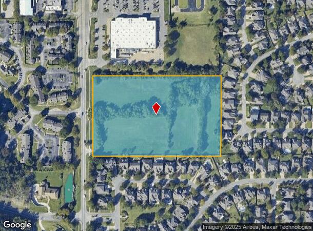
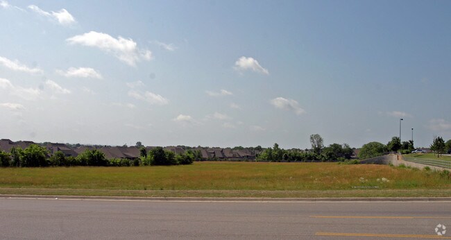
8310 S Sheridan Rd E
Tulsa, OK
Unplatted
98314-83-14-40930
PRT NW NW BEG 752.19S & 840E NWC NW TH W790 S484.32 E790 N TO POB SEC 14 18 13 8.784ACS
Commercialacreage
Tulsa
X
Oklahoma
40143C0367L
8.78 AC
2025
South Central
2025
Tulsa
007527
DEMOGRAPHICS near 8310 S Sheridan Rd E
1 Mile
3 Mile
5 Mile
2024 Total Population
12,527
90,382
208,060
2029 Population
12,825
93,104
214,809
Pop Growth 2024-2029
+ 2.38%
+ 3.01%
+ 3.24%
Average Age
41
41
40
2024 Total Households
5,321
38,583
87,407
HH Growth 2024-2029
+ 2.52%
+ 3.05%
+ 3.29%
Median Household Inc
$84,580
$72,997
$65,372
Avg Household Size
2.30
2.20
2.30
2024 Avg HH Vehicles
2.00
2.00
2.00
Median Home Value
$248,875
$256,674
$244,258
Median Year Built
1984
1985
1983
Nearby Places
Map Layers
Map Styles
 Street
 Aerial
- Restaurants
- Banks
- Shops
- Fitness
- Groceries
PUBLIC TRANSPORTATION
AIRPORT
Tulsa International
DRIVE
WALK
Distance
Tulsa International
25 min
12.8 mi
Freight Ports
Tulsa Port Of Catoosa
DRIVE
WALK
Distance
Tulsa Port Of Catoosa
30 min
21.2 mi
Nearby Properties
Address
Land Use
TOTAL SIZE
Lot Size
Zoning
Address
Land Use
TOTAL SIZE
Lot Size
Zoning
2,622,731 SF
26.90 AC
OH
Address
Land Use
TOTAL SIZE
Lot Size
Zoning
717,386 SF
49.74 AC
OL
Address
Land Use
TOTAL SIZE
Lot Size
Zoning
790,247 SF
149.86 AC
RS3
Address
Land Use
TOTAL SIZE
Lot Size
Zoning
323,882 SF
20 AC
CO
Address
Land Use
TOTAL SIZE
Lot Size
Zoning
157,138 SF
9.28 AC
CO
Address
Land Use
TOTAL SIZE
Lot Size
Zoning
184,679 SF
33.97 AC
AG
Address
Land Use
TOTAL SIZE
Lot Size
Zoning
236,738 SF
11.56 AC
PUD
Address
Land Use
TOTAL SIZE
Lot Size
Zoning
139,648 SF
20.75 AC
RS3
Address
Land Use
TOTAL SIZE
Lot Size
Zoning
61,153 SF
7.16 AC
CH
Address
Land Use
TOTAL SIZE
Lot Size
Zoning
206,760 SF
78.45 AC
AG
Address
Land Use
TOTAL SIZE
Lot Size
Zoning
163,472 SF
29.92 AC
AG
Address
Land Use
TOTAL SIZE
Lot Size
Zoning
72,042 SF
5.10 AC
RS3
Address
Land Use
TOTAL SIZE
Lot Size
Zoning
592,682 SF
30.42 AC
CO
Address
Land Use
TOTAL SIZE
Lot Size
Zoning
6,338 SF
104.15 AC
AG
Address
Land Use
TOTAL SIZE
Lot Size
Zoning
55,384 SF
14.81 AC
AG
Address
Land Use
TOTAL SIZE
Lot Size
Zoning
107,538 SF
19.74 AC
OM
Address
Land Use
TOTAL SIZE
Lot Size
Zoning
8,388 SF
63.49 AC
AG
Address
Land Use
TOTAL SIZE
Lot Size
Zoning
176,243 SF
5.77 AC
CS
Address
Land Use
TOTAL SIZE
Lot Size
Zoning
152,422 SF
44.60 AC
AG
Address
Land Use
TOTAL SIZE
Lot Size
Zoning
65,385 SF
16.59 AC
AG
Address
Land Use
TOTAL SIZE
Lot Size
Zoning
58,864 SF
5.18 AC
RS3
Address
Land Use
TOTAL SIZE
Lot Size
Zoning
65,812 SF
14.12 AC
RS1
Address
Land Use
TOTAL SIZE
Lot Size
Zoning
33,668 SF
8.04 AC
CO
Address
Land Use
TOTAL SIZE
Lot Size
Zoning
27,278 SF
2.49 AC
CS
Address
Land Use
TOTAL SIZE
Lot Size
Zoning
98,290 SF
19.62 AC
RS3
Address
Land Use
TOTAL SIZE
Lot Size
Zoning
86,747 SF
19.01 AC
RS3
Address
Land Use
TOTAL SIZE
Lot Size
Zoning
1,011,877 SF
5.55 AC
CH
Address
Land Use
TOTAL SIZE
Lot Size
Zoning
56,526 SF
25.18 AC
AG
Address
Land Use
TOTAL SIZE
Lot Size
Zoning
365,433 SF
18.39 AC
CO
Address
Land Use
TOTAL SIZE
Lot Size
Zoning
24,134 SF
7.47 AC
OM
The World's #1 Commercial Real Estate Marketplace
Connect with us
© 2025 CoStar Group
The information above has been obtained from sources believed reliable. While we do not doubt its accuracy we have not verified it and make no guarantee, warranty or representation about it. It is your responsibility to independently confirm its accuracy and completeness. Any projections, opinions, assumptions, or estimates used are for example only and do not represent the current or future performance of the property. The value of this transaction to you depends on tax and other factors which should be evaluated by your tax, financial, and legal advisors. You and your advisors should conduct a careful, independent investigation of the property to determine to your satisfaction the suitability of the property for your needs.