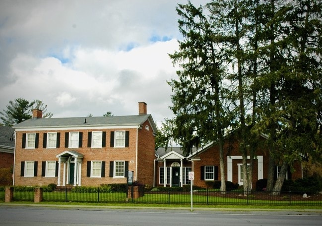
Property Record
832 Hanshaw Rd, Ithaca, NY 14850

NEARBY LISTINGS FOR SALE OR LEASE
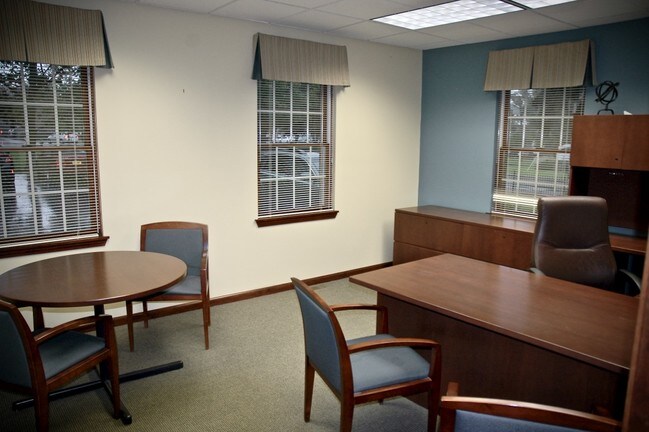
Property Detail
832 Hanshaw Rd
503001-005-000-0003-019-002-0000
Tompkins
Officebuilding
New York
X
19.002
36109C0201D
0.93 AC
2025
Northeast Ithaca
2024
Other Market Areas
000500
Ithaca, NY
5,246 SF
DEMOGRAPHICS near 832 Hanshaw Rd
1 Mile
3 Mile
5 Mile
2024 Total Population
11,409
47,173
63,416
2029 Population
10,325
41,182
55,487
Pop Growth 2024-2029
(9.50%)
(12.70%)
(12.50%)
Average Age
34
34
35
2024 Total Households
3,391
18,153
23,758
HH Growth 2024-2029
(14.04%)
(16.50%)
(16.38%)
Median Household Inc
$86,772
$59,043
$64,003
Avg Household Size
2.10
2.00
2.00
2024 Avg HH Vehicles
1.00
1.00
1.00
Median Home Value
$383,618
$342,823
$331,870
Median Year Built
1974
1971
1973
Nearby Places
Map Layers
Map Styles
 Street
 Aerial
- Restaurants
- Banks
- Shops
- Fitness
- Groceries
PUBLIC TRANSPORTATION
AIRPORT
Ithaca Tompkins International
DRIVE
WALK
Distance
Ithaca Tompkins International
5 min
2.5 mi
Freight Ports
Albany, NY Port
DRIVE
WALK
Distance
Albany, NY Port
223 min
167.5 mi
SALE & LEASE HISTORY
LISTING DATE
SALE/LEASE

Oct 25, 2018
For Lease
Oct 19, 2018
For Lease
Jul 28, 2021
For Lease
Nearby Properties
Address
Land Use
TOTAL SIZE
Lot Size
Zoning
Address
Land Use
TOTAL SIZE
Lot Size
Zoning
5,000 SF
154.28 AC
U-1
Address
Land Use
TOTAL SIZE
Lot Size
Zoning
43 AC
Address
Land Use
TOTAL SIZE
Lot Size
Zoning
36,275 SF
157.84 AC
Address
Land Use
TOTAL SIZE
Lot Size
Zoning
378,445 SF
4.39 AC
Address
Land Use
TOTAL SIZE
Lot Size
Zoning
338,706 SF
2.08 AC
U-1
Address
Land Use
TOTAL SIZE
Lot Size
Zoning
276,302 SF
15.94 AC
Address
Land Use
TOTAL SIZE
Lot Size
Zoning
1.30 AC
U-1
Address
Land Use
TOTAL SIZE
Lot Size
Zoning
50,319 SF
25.92 AC
Address
Land Use
TOTAL SIZE
Lot Size
Zoning
19,600 SF
22.51 AC
P-1
Address
Land Use
TOTAL SIZE
Lot Size
Zoning
32,162 SF
351.71 AC
Address
Land Use
TOTAL SIZE
Lot Size
Zoning
218,211 SF
0.76 AC
CBD-60
Address
Land Use
TOTAL SIZE
Lot Size
Zoning
150,015 SF
4.94 AC
U-1
Address
Land Use
TOTAL SIZE
Lot Size
Zoning
199,578 SF
0.56 AC
CBD-60
Address
Land Use
TOTAL SIZE
Lot Size
Zoning
364,128 SF
107.14 AC
Address
Land Use
TOTAL SIZE
Lot Size
Zoning
20,834 SF
32.98 AC
Address
Land Use
TOTAL SIZE
Lot Size
Zoning
140,488 SF
5.90 AC
Address
Land Use
TOTAL SIZE
Lot Size
Zoning
131,532 SF
2.20 AC
U-1
Address
Land Use
TOTAL SIZE
Lot Size
Zoning
93,573 SF
0.91 AC
Address
Land Use
TOTAL SIZE
Lot Size
Zoning
8,100 SF
0.51 AC
CBD-60
Address
Land Use
TOTAL SIZE
Lot Size
Zoning
116,854 SF
1.16 AC
Address
Land Use
TOTAL SIZE
Lot Size
Zoning
115,796 SF
26.51 AC
Address
Land Use
TOTAL SIZE
Lot Size
Zoning
0.93 AC
U-1
Address
Land Use
TOTAL SIZE
Lot Size
Zoning
228,978 SF
4.96 AC
Address
Land Use
TOTAL SIZE
Lot Size
Zoning
130,781 SF
20.10 AC
Address
Land Use
TOTAL SIZE
Lot Size
Zoning
75,168 SF
22.92 AC
Address
Land Use
TOTAL SIZE
Lot Size
Zoning
112,392 SF
0.76 AC
B-2B
Address
Land Use
TOTAL SIZE
Lot Size
Zoning
185,997 SF
0.17 AC
CBD-140
Address
Land Use
TOTAL SIZE
Lot Size
Zoning
26,658 SF
0.69 AC
R-3A
Address
Land Use
TOTAL SIZE
Lot Size
Zoning
5,555 SF
12.07 AC
P-1
The World's #1 Commercial Real Estate Marketplace
Connect with us
© 2025 CoStar Group
The information above has been obtained from sources believed reliable. While we do not doubt its accuracy we have not verified it and make no guarantee, warranty or representation about it. It is your responsibility to independently confirm its accuracy and completeness. Any projections, opinions, assumptions, or estimates used are for example only and do not represent the current or future performance of the property. The value of this transaction to you depends on tax and other factors which should be evaluated by your tax, financial, and legal advisors. You and your advisors should conduct a careful, independent investigation of the property to determine to your satisfaction the suitability of the property for your needs.