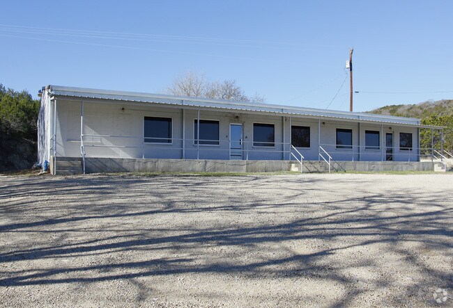
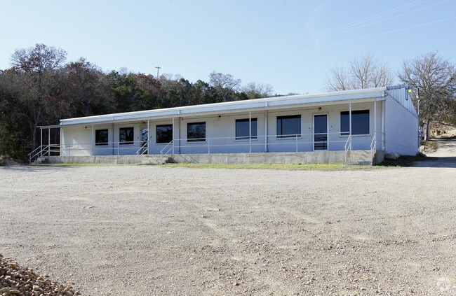
Property Record
832 Harper Rd, Kerrville, TX 78028

Property Detail
832 Harper Rd
R21187
ABS A1435 LEAVELL, SUR 1862,ACRES 2.72,(IMP ONLY 70007) (IMP ONLY 70007)
Commercialnec
Kerr
B and X Area of moderate flood hazard, usually the area between the limits of the 100-year and 500-year floods.
Texas
2025
2.72 AC
2025
Texas Hill Country
960101
Other Market Areas
4,186 SF
Kerrville, TX
NEARBY LISTINGS FOR SALE OR LEASE
DEMOGRAPHICS near 832 Harper Rd
1 mile
3 mile
5 mile
2024 Total Population
2,185
19,389
36,508
2029 Population
2,331
20,712
38,873
Pop Growth 2024-2029
+ 6.68%
+ 6.82%
+ 6.48%
Average Age
47
47
46
2024 Total Households
874
8,597
15,484
HH Growth 2024-2029
+ 6.75%
+ 6.97%
+ 6.65%
Median Household Inc
$81,971
$59,258
$58,053
Avg Household Size
2.40
2.20
2.20
2024 Avg HH Vehicles
2.00
2.00
2.00
Median Home Value
$267,884
$237,411
$225,968
Median Year Built
1977
1982
1985
Nearby Places
Map Layers
Map Styles
 Street
 Aerial
Transit
 Traffic
 Biking
Places
Listings with unknown addresses are not visible on the map
- Restaurants
- Banks
- Shops
- Fitness
- Groceries
SALE & LEASE HISTORY
LISTING DATE
SALE/LEASE

Jun 22, 2017
For Lease
Nearby Properties
Address
Land Use
TOTAL SIZE
Lot Size
Zoning
Address
Land Use
TOTAL SIZE
Lot Size
Zoning
42,380 SF
7.55 AC
Address
Land Use
TOTAL SIZE
Lot Size
Zoning
111,363 SF
7.89 AC
C2
Address
Land Use
TOTAL SIZE
Lot Size
Zoning
201,788 SF
19.79 AC
C2
Address
Land Use
TOTAL SIZE
Lot Size
Zoning
52,258 SF
5.21 AC
Address
Land Use
TOTAL SIZE
Lot Size
Zoning
72,875 SF
16.97 AC
Address
Land Use
TOTAL SIZE
Lot Size
Zoning
1,440 SF
7.24 AC
C2
Address
Land Use
TOTAL SIZE
Lot Size
Zoning
163,540 SF
8.87 AC
C2
Address
Land Use
TOTAL SIZE
Lot Size
Zoning
27,400 SF
3.20 AC
Address
Land Use
TOTAL SIZE
Lot Size
Zoning
90,723 SF
2.72 AC
C2
Address
Land Use
TOTAL SIZE
Lot Size
Zoning
34,900 SF
1.32 AC
Address
Land Use
TOTAL SIZE
Lot Size
Zoning
138,319 SF
14.59 AC
Address
Land Use
TOTAL SIZE
Lot Size
Zoning
33,369 SF
11.53 AC
Address
Land Use
TOTAL SIZE
Lot Size
Zoning
10,744 SF
5.82 AC
C1
Address
Land Use
TOTAL SIZE
Lot Size
Zoning
47,756 SF
16.17 AC
Address
Land Use
TOTAL SIZE
Lot Size
Zoning
97,331 SF
14.14 AC
Address
Land Use
TOTAL SIZE
Lot Size
Zoning
6,432 SF
5.03 AC
C2
Address
Land Use
TOTAL SIZE
Lot Size
Zoning
111,420 SF
8.83 AC
C2
Address
Land Use
TOTAL SIZE
Lot Size
Zoning
54,599 SF
5.02 AC
Address
Land Use
TOTAL SIZE
Lot Size
Zoning
57,119 SF
3.69 AC
C3
Address
Land Use
TOTAL SIZE
Lot Size
Zoning
37,006 SF
1.76 AC
Address
Land Use
TOTAL SIZE
Lot Size
Zoning
7,872 SF
4.02 AC
Address
Land Use
TOTAL SIZE
Lot Size
Zoning
166,497 SF
20.34 AC
C2
Address
Land Use
TOTAL SIZE
Lot Size
Zoning
54,546 SF
4.76 AC
Address
Land Use
TOTAL SIZE
Lot Size
Zoning
25.23 AC
Address
Land Use
TOTAL SIZE
Lot Size
Zoning
104,737 SF
8.91 AC
C2
Address
Land Use
TOTAL SIZE
Lot Size
Zoning
67,740 SF
2.39 AC
C2
Address
Land Use
TOTAL SIZE
Lot Size
Zoning
19,574 SF
1.96 AC
C2
Address
Land Use
TOTAL SIZE
Lot Size
Zoning
14,192 SF
3.56 AC
Address
Land Use
TOTAL SIZE
Lot Size
Zoning
32,639 SF
4.94 AC
C2
Address
Land Use
TOTAL SIZE
Lot Size
Zoning
15,440 SF
0.77 AC
The World's #1 Commercial Real Estate Marketplace
Connect with us
© 2026 CoStar Group
The information above has been obtained from sources believed reliable. While we do not doubt its accuracy we have not verified it and make no guarantee, warranty or representation about it. It is your responsibility to independently confirm its accuracy and completeness. Any projections, opinions, assumptions, or estimates used are for example only and do not represent the current or future performance of the property. The value of this transaction to you depends on tax and other factors which should be evaluated by your tax, financial, and legal advisors. You and your advisors should conduct a careful, independent investigation of the property to determine to your satisfaction the suitability of the property for your needs.