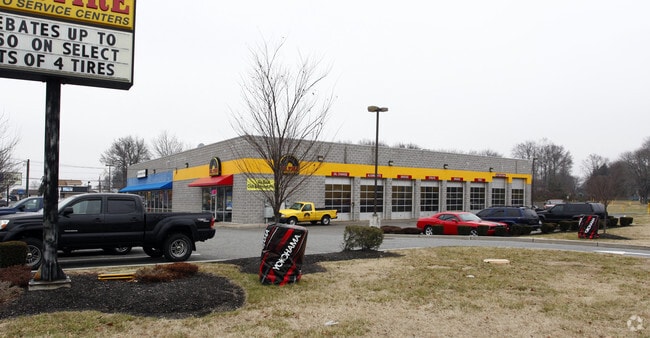
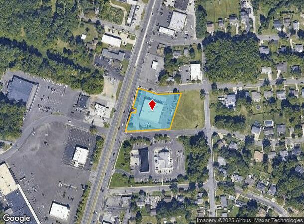
Property Record
832 Mantua Pike, Woodbury Heights, NJ 08097
Current Lease Availabilities
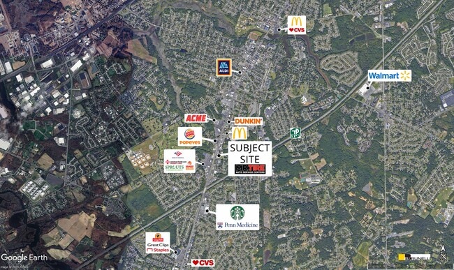
NEARBY LISTINGS FOR SALE OR LEASE
Property Detail
832 Mantua Pike
Philadelphia-Camden-Wilmington, PA-NJ-DE-MD
ALSO LOTS 4 5D & 5A LAND CODE 1 8
23-00005-0000-00003
Gloucester
Commercialnec
New Jersey
X
3
34015C0083F
3 AC
2024
Gloucester County
2025
Philadelphia
500900
DEMOGRAPHICS near 832 Mantua Pike
1 Mile
3 Mile
5 Mile
2024 Total Population
9,595
68,160
133,354
2029 Population
9,913
70,447
137,150
Pop Growth 2024-2029
+ 3.31%
+ 3.36%
+ 2.85%
Average Age
41
42
41
2024 Total Households
3,651
27,066
52,629
HH Growth 2024-2029
+ 3.37%
+ 3.38%
+ 2.84%
Median Household Inc
$82,343
$86,432
$85,428
Avg Household Size
2.60
2.50
2.50
2024 Avg HH Vehicles
2.00
2.00
2.00
Median Home Value
$229,230
$235,816
$237,101
Median Year Built
1959
1970
1968
Nearby Places
- Restaurants
- Banks
- Shops
- Fitness
- Groceries
PUBLIC TRANSPORTATION
AIRPORT
Philadelphia International
DRIVE
WALK
Distance
Philadelphia International
32 min
16.8 mi
Freight Ports
Broadway Terminal - Pier 5
DRIVE
WALK
Distance
Broadway Terminal - Pier 5
15 min
6.9 mi
Nearby Properties
Address
Land Use
TOTAL SIZE
Lot Size
Zoning
Address
Land Use
TOTAL SIZE
Lot Size
Zoning
69.05 AC
M2
Address
Land Use
TOTAL SIZE
Lot Size
Zoning
32.64 AC
INS
Address
Land Use
TOTAL SIZE
Lot Size
Zoning
1.66 AC
R01
Address
Land Use
TOTAL SIZE
Lot Size
Zoning
25.77 AC
R10
Address
Land Use
TOTAL SIZE
Lot Size
Zoning
57.58 AC
C
Address
Land Use
TOTAL SIZE
Lot Size
Zoning
32.20 AC
R-1
Address
Land Use
TOTAL SIZE
Lot Size
Zoning
21.32 AC
Address
Land Use
TOTAL SIZE
Lot Size
Zoning
35.50 AC
R4
Address
Land Use
TOTAL SIZE
Lot Size
Zoning
32.88 AC
M1
Address
Land Use
TOTAL SIZE
Lot Size
Zoning
Address
Land Use
TOTAL SIZE
Lot Size
Zoning
63.46 AC
INS
Address
Land Use
TOTAL SIZE
Lot Size
Zoning
29.23 AC
BC3
Address
Land Use
TOTAL SIZE
Lot Size
Zoning
4.93 AC
Address
Land Use
TOTAL SIZE
Lot Size
Zoning
22.60 AC
R4
Address
Land Use
TOTAL SIZE
Lot Size
Zoning
38.17 AC
R4
Address
Land Use
TOTAL SIZE
Lot Size
Zoning
24.27 AC
M2
Address
Land Use
TOTAL SIZE
Lot Size
Zoning
3.22 AC
PA
Address
Land Use
TOTAL SIZE
Lot Size
Zoning
1.11 AC
R4
Address
Land Use
TOTAL SIZE
Lot Size
Zoning
55.38 AC
M2
Address
Land Use
TOTAL SIZE
Lot Size
Zoning
36.52 AC
M1
Address
Land Use
TOTAL SIZE
Lot Size
Zoning
21.81 AC
RM2
Address
Land Use
TOTAL SIZE
Lot Size
Zoning
31 AC
M1
Address
Land Use
TOTAL SIZE
Lot Size
Zoning
Address
Land Use
TOTAL SIZE
Lot Size
Zoning
12.14 AC
Address
Land Use
TOTAL SIZE
Lot Size
Zoning
21.40 AC
R2
Address
Land Use
TOTAL SIZE
Lot Size
Zoning
19.34 AC
R1
Address
Land Use
TOTAL SIZE
Lot Size
Zoning
27.18 AC
M1
Address
Land Use
TOTAL SIZE
Lot Size
Zoning
23.14 AC
RM2
Address
Land Use
TOTAL SIZE
Lot Size
Zoning
7.01 AC
R11
Address
Land Use
TOTAL SIZE
Lot Size
Zoning
9,576 SF
1.14 AC
MH
The World's #1 Commercial Real Estate Marketplace
Connect with us
© 2025 CoStar Group
The information above has been obtained from sources believed reliable. While we do not doubt its accuracy we have not verified it and make no guarantee, warranty or representation about it. It is your responsibility to independently confirm its accuracy and completeness. Any projections, opinions, assumptions, or estimates used are for example only and do not represent the current or future performance of the property. The value of this transaction to you depends on tax and other factors which should be evaluated by your tax, financial, and legal advisors. You and your advisors should conduct a careful, independent investigation of the property to determine to your satisfaction the suitability of the property for your needs.