Property Record
8320 E 71St St, Tulsa, OK 74133
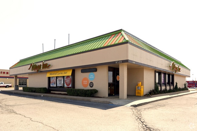


Property Detail
8320 E 71St St
77303-83-12-04920
LT 3 LESS S40 THEREOF BLK 1
Storebuilding
Tulsa
CS
Oklahoma
B and X Area of moderate flood hazard, usually the area between the limits of the 100-year and 500-year floods.
3
2025
0.85 AC
2025
South Central Tulsa
007646
Tulsa
5,402 SF
Tulsa, OK
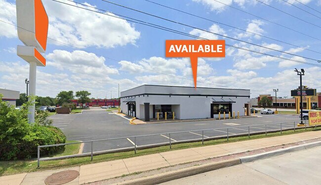
NEARBY LISTINGS FOR SALE OR LEASE
DEMOGRAPHICS near 8320 E 71St St
1 mile
3 mile
5 mile
2025 Total Population
15,034
91,570
246,885
2030 Population
15,436
94,058
253,304
Pop Growth 2025-2030
+ 2.67%
+ 2.72%
+ 2.60%
Average Age
40
40
39
2025 Total Households
6,924
39,312
102,230
HH Growth 2025-2030
+ 2.66%
+ 2.83%
+ 2.72%
Median Household Inc
$59,024
$69,796
$68,368
Avg Household Size
2.10
2.30
2.30
2025 Avg HH Vehicles
1.00
2.00
2.00
Median Home Value
$241,659
$265,919
$266,715
Median Year Built
1984
1984
1980
Nearby Places
Map Layers
Map Styles
 Street
 Aerial
Layers
 Traffic
 Biking
Places
Listings with unknown addresses are not visible on the map
- Restaurants
- Banks
- Shops
- Fitness
- Groceries
PUBLIC TRANSPORTATION
AIRPORT
Tulsa International
Drive
Walk
Distance
Tulsa International
23 min
15.2 mi
Freight Ports
Drive
Walk
Distance
26 min
18.9 mi
SALE & LEASE HISTORY
LISTING DATE
SALE/LEASE

Oct 04, 2022
For Lease
May 08, 2020
For Sale
May 08, 2020
For Lease
Nearby Properties
Address
Land Use
TOTAL SIZE
Lot Size
Zoning
Address
Land Use
TOTAL SIZE
Lot Size
Zoning
2,622,731 SF
26.90 AC
OH
Address
Land Use
TOTAL SIZE
Lot Size
Zoning
717,386 SF
49.74 AC
OL
Address
Land Use
TOTAL SIZE
Lot Size
Zoning
323,882 SF
20 AC
CO
Address
Land Use
TOTAL SIZE
Lot Size
Zoning
157,138 SF
9.28 AC
CO
Address
Land Use
TOTAL SIZE
Lot Size
Zoning
80,431 SF
9.51 AC
IL
Address
Land Use
TOTAL SIZE
Lot Size
Zoning
184,679 SF
33.97 AC
AG
Address
Land Use
TOTAL SIZE
Lot Size
Zoning
236,738 SF
11.56 AC
PUD
Address
Land Use
TOTAL SIZE
Lot Size
Zoning
139,648 SF
20.75 AC
RS3
Address
Land Use
TOTAL SIZE
Lot Size
Zoning
61,153 SF
7.16 AC
CH
Address
Land Use
TOTAL SIZE
Lot Size
Zoning
206,760 SF
78.45 AC
AG
Address
Land Use
TOTAL SIZE
Lot Size
Zoning
163,472 SF
29.92 AC
AG
Address
Land Use
TOTAL SIZE
Lot Size
Zoning
25,173 SF
155.93 AC
RS3
Address
Land Use
TOTAL SIZE
Lot Size
Zoning
72,042 SF
5.10 AC
RS3
Address
Land Use
TOTAL SIZE
Lot Size
Zoning
592,682 SF
30.42 AC
CO
Address
Land Use
TOTAL SIZE
Lot Size
Zoning
55,384 SF
14.81 AC
AG
Address
Land Use
TOTAL SIZE
Lot Size
Zoning
45,191 SF
6.30 AC
CS
Address
Land Use
TOTAL SIZE
Lot Size
Zoning
8,388 SF
63.49 AC
AG
Address
Land Use
TOTAL SIZE
Lot Size
Zoning
56,611 SF
26.92 AC
RS2
Address
Land Use
TOTAL SIZE
Lot Size
Zoning
152,422 SF
44.60 AC
AG
Address
Land Use
TOTAL SIZE
Lot Size
Zoning
58,864 SF
5.18 AC
RS3
Address
Land Use
TOTAL SIZE
Lot Size
Zoning
625 SF
78.96 AC
RS3
Address
Land Use
TOTAL SIZE
Lot Size
Zoning
65,812 SF
14.12 AC
RS1
Address
Land Use
TOTAL SIZE
Lot Size
Zoning
33,668 SF
8.04 AC
CO
Address
Land Use
TOTAL SIZE
Lot Size
Zoning
74,600 SF
3.65 AC
RM2
Address
Land Use
TOTAL SIZE
Lot Size
Zoning
86,747 SF
19.01 AC
RS3
Address
Land Use
TOTAL SIZE
Lot Size
Zoning
1,011,877 SF
5.55 AC
CH
Address
Land Use
TOTAL SIZE
Lot Size
Zoning
57,630 SF
35.09 AC
IL
Address
Land Use
TOTAL SIZE
Lot Size
Zoning
24,134 SF
7.47 AC
OM
Address
Land Use
TOTAL SIZE
Lot Size
Zoning
22,938 SF
2.95 AC
OM
Address
Land Use
TOTAL SIZE
Lot Size
Zoning
968,758 SF
4.86 AC
CH
The World's #1 Commercial Real Estate Marketplace
Connect with us
© 2026 CoStar Group
The information above has been obtained from sources believed reliable. While we do not doubt its accuracy we have not verified it and make no guarantee, warranty or representation about it. It is your responsibility to independently confirm its accuracy and completeness. Any projections, opinions, assumptions, or estimates used are for example only and do not represent the current or future performance of the property. The value of this transaction to you depends on tax and other factors which should be evaluated by your tax, financial, and legal advisors. You and your advisors should conduct a careful, independent investigation of the property to determine to your satisfaction the suitability of the property for your needs.