Property Record
8320 Us 301 N, Parrish, FL 34219
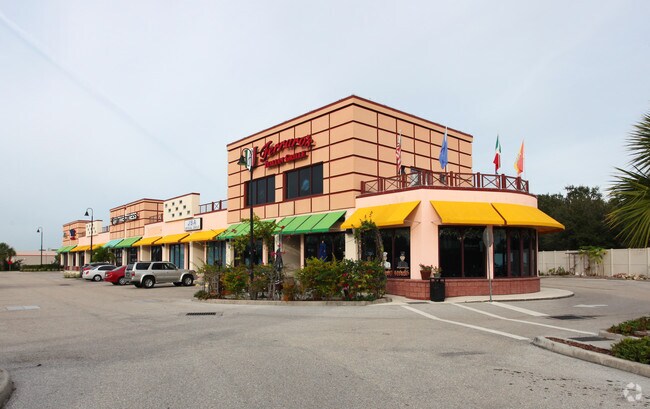


Property Detail
8320 Us 301 N
8500-1005-9
LOTS 9,10,11,12,13,14,15,16,17 & 18 BLK C, ROSE PARK SUB, LESS R/W FOR S.R. 43 (U.S. 301) AS TO SD LOTS 16,17 & 18 BLK C AS PER PARAGRAPH 3 OF THE FINAL JUDGMENT IN CIRCUIT
Storemultistory
MANATEE
GC GENERA
Florida
B and X Area of moderate flood hazard, usually the area between the limits of the 100-year and 500-year floods.
9
2023
1.29 AC
2025
Manatee
001913
Tampa/St Petersburg
19,000 SF
North Port-Bradenton-Sarasota, FL
NEARBY LISTINGS FOR SALE OR LEASE
-
-
View all Parrish listings for lease on LoopNet.com
DEMOGRAPHICS near 8320 Us 301 N
1 mile
3 mile
5 mile
2025 Total Population
8,275
48,266
113,627
2030 Population
9,344
54,214
128,824
Pop Growth 2025-2030
+ 12.92%
+ 12.32%
+ 13.37%
Average Age
60
48
46
2025 Total Households
4,335
20,571
45,694
HH Growth 2025-2030
+ 13.36%
+ 12.63%
+ 13.38%
Median Household Inc
$62,451
$93,186
$88,997
Avg Household Size
1.90
2.30
2.40
2025 Avg HH Vehicles
1.00
2.00
2.00
Median Home Value
$158,108
$404,185
$421,577
Median Year Built
1990
2006
2005
Nearby Places
Map Layers
Map Styles
 Street
 Aerial
Layers
 Traffic
 Biking
Places
Listings with unknown addresses are not visible on the map
- Restaurants
- Banks
- Shops
- Fitness
- Groceries
PUBLIC TRANSPORTATION
AIRPORT
Sarasota/Bradenton International
Drive
Walk
Distance
Sarasota/Bradenton International
29 min
15.6 mi
St Pete-Clearwater International
Drive
Walk
Distance
St Pete-Clearwater International
55 min
38.9 mi
Freight Ports
Port Manatee
Drive
Walk
Distance
Port Manatee
20 min
11.6 mi
SALE & LEASE HISTORY
LISTING DATE
SALE/LEASE

Dec 20, 2023
For Lease
Nearby Properties
Address
Land Use
TOTAL SIZE
Lot Size
Zoning
Address
Land Use
TOTAL SIZE
Lot Size
Zoning
622,266 SF
68.76 AC
PD-MU
Address
Land Use
TOTAL SIZE
Lot Size
Zoning
707,409 SF
27.98 AC
PD-MU
Address
Land Use
TOTAL SIZE
Lot Size
Zoning
359,241 SF
27.68 AC
PD-MU
Address
Land Use
TOTAL SIZE
Lot Size
Zoning
294,300 SF
10.33 AC
PD-MU
Address
Land Use
TOTAL SIZE
Lot Size
Zoning
313,422 SF
47.93 AC
PD-C
Address
Land Use
TOTAL SIZE
Lot Size
Zoning
456,375 SF
112.07 AC
PD-MU
Address
Land Use
TOTAL SIZE
Lot Size
Zoning
270,900 SF
44.35 AC
PD-MU
Address
Land Use
TOTAL SIZE
Lot Size
Zoning
456,317 SF
46.75 AC
PD-R
Address
Land Use
TOTAL SIZE
Lot Size
Zoning
312,546 SF
39.60 AC
A-1 SUBURB
Address
Land Use
TOTAL SIZE
Lot Size
Zoning
191,100 SF
30.35 AC
PD-C
Address
Land Use
TOTAL SIZE
Lot Size
Zoning
136.89 AC
Address
Land Use
TOTAL SIZE
Lot Size
Zoning
50.25 AC
Address
Land Use
TOTAL SIZE
Lot Size
Zoning
64,800 SF
8.19 AC
Address
Land Use
TOTAL SIZE
Lot Size
Zoning
13,621 SF
61.72 AC
PD-RV,RSF-
Address
Land Use
TOTAL SIZE
Lot Size
Zoning
61,770 SF
79.85 AC
A,A-1
Address
Land Use
TOTAL SIZE
Lot Size
Zoning
66,063 SF
9.24 AC
PD-C
Address
Land Use
TOTAL SIZE
Lot Size
Zoning
59,222 SF
4.49 AC
PD-C
Address
Land Use
TOTAL SIZE
Lot Size
Zoning
33.49 AC
Address
Land Use
TOTAL SIZE
Lot Size
Zoning
56,442 SF
6.18 AC
GC GENERA
Address
Land Use
TOTAL SIZE
Lot Size
Zoning
138,258 SF
9.59 AC
PD-MU
Address
Land Use
TOTAL SIZE
Lot Size
Zoning
61,721 SF
5.50 AC
PD-C
Address
Land Use
TOTAL SIZE
Lot Size
Zoning
128,400 SF
24.27 AC
A-1 SUBURB
Address
Land Use
TOTAL SIZE
Lot Size
Zoning
36,002 SF
4.41 AC
PD-C
Address
Land Use
TOTAL SIZE
Lot Size
Zoning
5,744 SF
12.60 AC
RSMH-6
Address
Land Use
TOTAL SIZE
Lot Size
Zoning
7.86 AC
PD-MU
Address
Land Use
TOTAL SIZE
Lot Size
Zoning
32,860 SF
4.05 AC
PD-O
Address
Land Use
TOTAL SIZE
Lot Size
Zoning
28,413 SF
5.40 AC
RSMH-6
Address
Land Use
TOTAL SIZE
Lot Size
Zoning
1,596 SF
106.35 AC
PD-R
Address
Land Use
TOTAL SIZE
Lot Size
Zoning
53,851 SF
6.32 AC
Address
Land Use
TOTAL SIZE
Lot Size
Zoning
41,168 SF
3.21 AC
PD-C
The World's #1 Commercial Real Estate Marketplace
Connect with us
© 2026 CoStar Group
The information above has been obtained from sources believed reliable. While we do not doubt its accuracy we have not verified it and make no guarantee, warranty or representation about it. It is your responsibility to independently confirm its accuracy and completeness. Any projections, opinions, assumptions, or estimates used are for example only and do not represent the current or future performance of the property. The value of this transaction to you depends on tax and other factors which should be evaluated by your tax, financial, and legal advisors. You and your advisors should conduct a careful, independent investigation of the property to determine to your satisfaction the suitability of the property for your needs.