Property Record
Highway 59, Hungerford, TX 77448
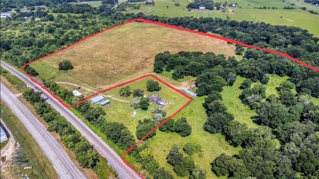
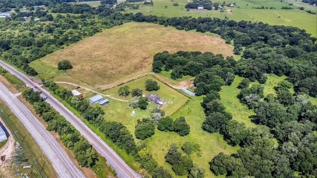
This Property Is For Sale
Property Detail
Highway 59
El Campo, TX
A20058 ABST.58 TRACT 52B,53B,52B-1A
R034374
WHARTON
Timberlandforesttreesagricultural
Texas
A Areas with a 1% annual chance of flooding and a 26% chance of flooding over the life of a 30-year mortgage.
34.11 AC
2024
Texas South Area
2025
Other Market Areas
740100
NEARBY LISTINGS FOR SALE OR LEASE
DEMOGRAPHICS near Highway 59
1 mile
3 mile
5 mile
2024 Total Population
66
577
2,842
2029 Population
62
575
2,869
Pop Growth 2024-2029
(6.06%)
(0.35%)
+ 0.95%
Average Age
45
43
42
2024 Total Households
24
212
1,075
HH Growth 2024-2029
(4.17%)
(0.47%)
+ 1.02%
Median Household Inc
$57,999
$55,526
$50,062
Avg Household Size
2.50
2.60
2.50
2024 Avg HH Vehicles
2.00
2.00
2.00
Median Home Value
$174,999
$174,999
$139,215
Median Year Built
1996
1984
1979
Nearby Places
Map Layers
Map Styles
 Street
 Aerial
Transit
 Traffic
 Biking
Places
Listings with unknown addresses are not visible on the map
- Restaurants
- Banks
- Shops
- Fitness
- Groceries
Nearby Properties
Address
Land Use
TOTAL SIZE
Lot Size
Zoning
Address
Land Use
TOTAL SIZE
Lot Size
Zoning
Address
Land Use
TOTAL SIZE
Lot Size
Zoning
52,561 SF
13.24 AC
Address
Land Use
TOTAL SIZE
Lot Size
Zoning
38,018 SF
2.31 AC
Address
Land Use
TOTAL SIZE
Lot Size
Zoning
7.03 AC
Address
Land Use
TOTAL SIZE
Lot Size
Zoning
9,040 SF
1.87 AC
Address
Land Use
TOTAL SIZE
Lot Size
Zoning
10,656 SF
1.90 AC
Address
Land Use
TOTAL SIZE
Lot Size
Zoning
Address
Land Use
TOTAL SIZE
Lot Size
Zoning
9,860 SF
1.29 AC
Address
Land Use
TOTAL SIZE
Lot Size
Zoning
72,234 SF
4.64 AC
Address
Land Use
TOTAL SIZE
Lot Size
Zoning
7,040 SF
9.39 AC
Address
Land Use
TOTAL SIZE
Lot Size
Zoning
5,363 SF
43 AC
Address
Land Use
TOTAL SIZE
Lot Size
Zoning
5,631 SF
36.22 AC
Address
Land Use
TOTAL SIZE
Lot Size
Zoning
15,597 SF
7.35 AC
Address
Land Use
TOTAL SIZE
Lot Size
Zoning
14.41 AC
Address
Land Use
TOTAL SIZE
Lot Size
Zoning
4,878 SF
12.97 AC
Address
Land Use
TOTAL SIZE
Lot Size
Zoning
4,008 SF
7.63 AC
Address
Land Use
TOTAL SIZE
Lot Size
Zoning
4,267 SF
4 AC
Address
Land Use
TOTAL SIZE
Lot Size
Zoning
4,464 SF
2.20 AC
Address
Land Use
TOTAL SIZE
Lot Size
Zoning
4,235 SF
10.07 AC
Address
Land Use
TOTAL SIZE
Lot Size
Zoning
4,560 SF
77.12 AC
Address
Land Use
TOTAL SIZE
Lot Size
Zoning
5,189 SF
24.05 AC
Address
Land Use
TOTAL SIZE
Lot Size
Zoning
5,472 SF
1.10 AC
Address
Land Use
TOTAL SIZE
Lot Size
Zoning
4,042 SF
3.15 AC
Address
Land Use
TOTAL SIZE
Lot Size
Zoning
2,852 SF
10 AC
Address
Land Use
TOTAL SIZE
Lot Size
Zoning
3,705 SF
2 AC
Address
Land Use
TOTAL SIZE
Lot Size
Zoning
19,649 SF
0.59 AC
Address
Land Use
TOTAL SIZE
Lot Size
Zoning
2,293 SF
3.96 AC
Address
Land Use
TOTAL SIZE
Lot Size
Zoning
820 SF
9.54 AC
Address
Land Use
TOTAL SIZE
Lot Size
Zoning
208.83 AC
Address
Land Use
TOTAL SIZE
Lot Size
Zoning
4,036 SF
14 AC
The World's #1 Commercial Real Estate Marketplace
Connect with us
© 2026 CoStar Group
The information above has been obtained from sources believed reliable. While we do not doubt its accuracy we have not verified it and make no guarantee, warranty or representation about it. It is your responsibility to independently confirm its accuracy and completeness. Any projections, opinions, assumptions, or estimates used are for example only and do not represent the current or future performance of the property. The value of this transaction to you depends on tax and other factors which should be evaluated by your tax, financial, and legal advisors. You and your advisors should conduct a careful, independent investigation of the property to determine to your satisfaction the suitability of the property for your needs.