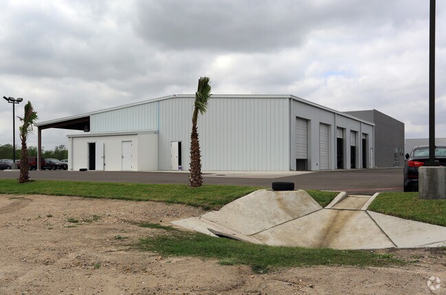
Property Record
8321 W Expressway 83, Harlingen, TX 78552


Save to a Folder
{{folder.Name}}
{{folder.ListingIds.length}} Properties
{{folder.ListingIds.length}} Property
Create a New Folder
Property Detail
8321 W Expressway 83
Brownsville-Harlingen, TX
LOT 4 ROBERT C VACKAR SUBDIVISION (C1-3113 B CCMR FILED 6/21/2012)
984249-0000-004000
CAMERON
Commercialnec
Texas
B and X Area of moderate flood hazard, usually the area between the limits of the 100-year and 500-year floods.
4
2024
3.81 AC
2025
Outlying Cameron County
012004
Brownsville/Harlingen
17,008 SF
NEARBY LISTINGS FOR SALE OR LEASE
-
-
View all Harlingen listings for sale on LoopNet.com
DEMOGRAPHICS near 8321 W Expressway 83
1 mile
3 mile
5 mile
2025 Total Population
3,930
28,872
68,465
2030 Population
4,100
30,064
70,982
Pop Growth 2025-2030
+ 4.33%
+ 4.13%
+ 3.68%
Average Age
39
39
38
2025 Total Households
1,304
10,127
23,066
HH Growth 2025-2030
+ 4.37%
+ 4.46%
+ 3.92%
Median Household Inc
$74,015
$70,675
$57,126
Avg Household Size
2.90
2.80
2.90
2025 Avg HH Vehicles
2.00
2.00
2.00
Median Home Value
$198,041
$210,919
$153,786
Median Year Built
1995
1997
1990
Nearby Places
Map Layers
Map Styles
 Street
 Aerial
Layers
 Traffic
 Biking
Places
Listings with unknown addresses are not visible on the map
- Restaurants
- Banks
- Shops
- Fitness
- Groceries
PUBLIC TRANSPORTATION
AIRPORT
Valley International
Drive
Walk
Distance
Valley International
16 min
10.1 mi
McAllen International
Drive
Walk
Distance
McAllen International
39 min
31.6 mi
Brownsville/South Padre Island International
Drive
Walk
Distance
Brownsville/South Padre Island International
41 min
31.7 mi
Freight Ports
Port of Brownsville
Drive
Walk
Distance
Port of Brownsville
34 min
29.4 mi
Nearby Properties
Address
Land Use
TOTAL SIZE
Lot Size
Zoning
Address
Land Use
TOTAL SIZE
Lot Size
Zoning
246,234 SF
16.40 AC
Address
Land Use
TOTAL SIZE
Lot Size
Zoning
41,182 SF
34.14 AC
M-R
Address
Land Use
TOTAL SIZE
Lot Size
Zoning
41,370 SF
3.40 AC
C
Address
Land Use
TOTAL SIZE
Lot Size
Zoning
51,748 SF
10 AC
Address
Land Use
TOTAL SIZE
Lot Size
Zoning
81,569 SF
36.61 AC
Address
Land Use
TOTAL SIZE
Lot Size
Zoning
91,630 SF
11.17 AC
Address
Land Use
TOTAL SIZE
Lot Size
Zoning
47,539 SF
8.77 AC
C
Address
Land Use
TOTAL SIZE
Lot Size
Zoning
77,077 SF
5.20 AC
Address
Land Use
TOTAL SIZE
Lot Size
Zoning
50,659 SF
6.43 AC
Address
Land Use
TOTAL SIZE
Lot Size
Zoning
18,016 SF
1.70 AC
Address
Land Use
TOTAL SIZE
Lot Size
Zoning
107,881 SF
20 AC
AU
Address
Land Use
TOTAL SIZE
Lot Size
Zoning
60,050 SF
1.98 AC
Address
Land Use
TOTAL SIZE
Lot Size
Zoning
47,388 SF
11.64 AC
Address
Land Use
TOTAL SIZE
Lot Size
Zoning
17,925 SF
6.34 AC
Address
Land Use
TOTAL SIZE
Lot Size
Zoning
70,941 SF
3.68 AC
C
Address
Land Use
TOTAL SIZE
Lot Size
Zoning
26,300 SF
3.82 AC
Address
Land Use
TOTAL SIZE
Lot Size
Zoning
1,216 SF
39.91 AC
A-R
Address
Land Use
TOTAL SIZE
Lot Size
Zoning
141,841 SF
9.99 AC
Address
Land Use
TOTAL SIZE
Lot Size
Zoning
20,160 SF
4 AC
Address
Land Use
TOTAL SIZE
Lot Size
Zoning
18,640 SF
4.07 AC
Address
Land Use
TOTAL SIZE
Lot Size
Zoning
3,900 SF
7.21 AC
C
Address
Land Use
TOTAL SIZE
Lot Size
Zoning
11,405 SF
4.91 AC
I
Address
Land Use
TOTAL SIZE
Lot Size
Zoning
10,095 SF
22.05 AC
Address
Land Use
TOTAL SIZE
Lot Size
Zoning
66,200 SF
3.07 AC
C
Address
Land Use
TOTAL SIZE
Lot Size
Zoning
7,178 SF
2.30 AC
Address
Land Use
TOTAL SIZE
Lot Size
Zoning
8,688 SF
14.67 AC
M-R
Address
Land Use
TOTAL SIZE
Lot Size
Zoning
6.31 AC
Address
Land Use
TOTAL SIZE
Lot Size
Zoning
50,670 SF
8.85 AC
C
Address
Land Use
TOTAL SIZE
Lot Size
Zoning
5,815 SF
10.35 AC
C
The World's #1 Commercial Real Estate Marketplace
Connect with us
© 2026 CoStar Group
The information above has been obtained from sources believed reliable. While we do not doubt its accuracy we have not verified it and make no guarantee, warranty or representation about it. It is your responsibility to independently confirm its accuracy and completeness. Any projections, opinions, assumptions, or estimates used are for example only and do not represent the current or future performance of the property. The value of this transaction to you depends on tax and other factors which should be evaluated by your tax, financial, and legal advisors. You and your advisors should conduct a careful, independent investigation of the property to determine to your satisfaction the suitability of the property for your needs.