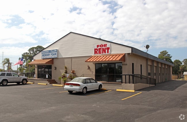
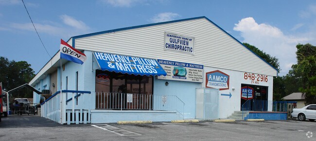
Property Record
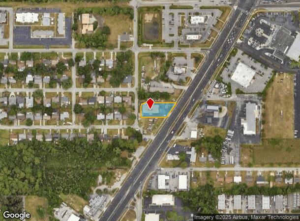
8323 Us Highway 19, Port Richey, FL 34668
NEARBY LISTINGS FOR SALE OR LEASE
Property Detail
8323 Us Highway 19
Tampa-St. Petersburg-Clearwater, FL
Richey Bay Park Resubdivision
29-25-16-0110-00T00-0010
RICHEY BAY PARK PB 4 PG 43 BLOCK T NORTH 100.00 FT LYING WEST OF R/W LINE OF US HWY 19 OR 4436 PG 1232
Warehouse
Pasco
AE
Florida
12101C0188G
1
2024
0.47 AC
2025
Pasco County
030205
Tampa/St Petersburg
5,940 SF
DEMOGRAPHICS near 8323 Us Highway 19
1 Mile
3 Mile
5 Mile
2024 Total Population
5,590
65,125
143,278
2029 Population
6,699
78,172
171,954
Pop Growth 2024-2029
+ 19.84%
+ 20.03%
+ 20.01%
Average Age
43
44
45
2024 Total Households
2,505
28,642
63,086
HH Growth 2024-2029
+ 19.84%
+ 20.06%
+ 20.04%
Median Household Inc
$36,898
$43,425
$45,570
Avg Household Size
2.20
2.20
2.20
2024 Avg HH Vehicles
1.00
1.00
2.00
Median Home Value
$178,168
$152,128
$159,735
Median Year Built
1977
1978
1978
Nearby Places
Map Layers
Map Styles
 Street
 Aerial
- Restaurants
- Banks
- Shops
- Fitness
- Groceries
PUBLIC TRANSPORTATION
AIRPORT
St Pete-Clearwater International
DRIVE
WALK
Distance
St Pete-Clearwater International
44 min
28.2 mi
Tampa International
DRIVE
WALK
Distance
Tampa International
54 min
31.8 mi
Freight Ports
Port of Tampa Bay
DRIVE
WALK
Distance
Port of Tampa Bay
67 min
41.7 mi
Nearby Properties
Address
Land Use
TOTAL SIZE
Lot Size
Zoning
Address
Land Use
TOTAL SIZE
Lot Size
Zoning
395,386 SF
35.63 AC
C2
Address
Land Use
TOTAL SIZE
Lot Size
Zoning
799,241 SF
88.92 AC
PUD
Address
Land Use
TOTAL SIZE
Lot Size
Zoning
248,561 SF
14.17 AC
C
Address
Land Use
TOTAL SIZE
Lot Size
Zoning
351,012 SF
23.51 AC
MF2
Address
Land Use
TOTAL SIZE
Lot Size
Zoning
220,843 SF
35.13 AC
C2
Address
Land Use
TOTAL SIZE
Lot Size
Zoning
416,037 SF
50.65 AC
C1
Address
Land Use
TOTAL SIZE
Lot Size
Zoning
141,740 SF
22.84 AC
PO1
Address
Land Use
TOTAL SIZE
Lot Size
Zoning
149,162 SF
3.10 AC
C
Address
Land Use
TOTAL SIZE
Lot Size
Zoning
122,037 SF
13.83 AC
MF1
Address
Land Use
TOTAL SIZE
Lot Size
Zoning
121,284 SF
10.25 AC
MF1
Address
Land Use
TOTAL SIZE
Lot Size
Zoning
91,660 SF
16.29 AC
C
Address
Land Use
TOTAL SIZE
Lot Size
Zoning
220,045 SF
22.67 AC
C2
Address
Land Use
TOTAL SIZE
Lot Size
Zoning
309,759 SF
65.19 AC
AC
Address
Land Use
TOTAL SIZE
Lot Size
Zoning
183,139 SF
19.66 AC
C2
Address
Land Use
TOTAL SIZE
Lot Size
Zoning
217,350 SF
11.20 AC
PUD
Address
Land Use
TOTAL SIZE
Lot Size
Zoning
142,856 SF
20 AC
C
Address
Land Use
TOTAL SIZE
Lot Size
Zoning
76,160 SF
6.74 AC
MPUD
Address
Land Use
TOTAL SIZE
Lot Size
Zoning
220,024 SF
25.72 AC
C1
Address
Land Use
TOTAL SIZE
Lot Size
Zoning
86,570 SF
8.06 AC
MF1
Address
Land Use
TOTAL SIZE
Lot Size
Zoning
137,157 SF
18.59 AC
C2
Address
Land Use
TOTAL SIZE
Lot Size
Zoning
212,308 SF
10.91 AC
MF2
Address
Land Use
TOTAL SIZE
Lot Size
Zoning
41,156 SF
2.26 AC
C
Address
Land Use
TOTAL SIZE
Lot Size
Zoning
42,059 SF
9.16 AC
C3
Address
Land Use
TOTAL SIZE
Lot Size
Zoning
84,225 SF
5.21 AC
C2
Address
Land Use
TOTAL SIZE
Lot Size
Zoning
181,980 SF
11.12 AC
MF2
Address
Land Use
TOTAL SIZE
Lot Size
Zoning
77,439 SF
4.36 AC
C
Address
Land Use
TOTAL SIZE
Lot Size
Zoning
91,670 SF
3.51 AC
C2
Address
Land Use
TOTAL SIZE
Lot Size
Zoning
117,549 SF
8.07 AC
C2
Address
Land Use
TOTAL SIZE
Lot Size
Zoning
78,580 SF
21.43 AC
PUD
Address
Land Use
TOTAL SIZE
Lot Size
Zoning
39,542 SF
4.25 AC
MF1
The World's #1 Commercial Real Estate Marketplace
Connect with us
© 2025 CoStar Group
The information above has been obtained from sources believed reliable. While we do not doubt its accuracy we have not verified it and make no guarantee, warranty or representation about it. It is your responsibility to independently confirm its accuracy and completeness. Any projections, opinions, assumptions, or estimates used are for example only and do not represent the current or future performance of the property. The value of this transaction to you depends on tax and other factors which should be evaluated by your tax, financial, and legal advisors. You and your advisors should conduct a careful, independent investigation of the property to determine to your satisfaction the suitability of the property for your needs.