Property Record
8325 S Us Highway 1 S, Bunnell, FL 32110
NEARBY LISTINGS FOR SALE OR LEASE
-
-
View all Bunnell listings for sale on LoopNet.com
Property Detail
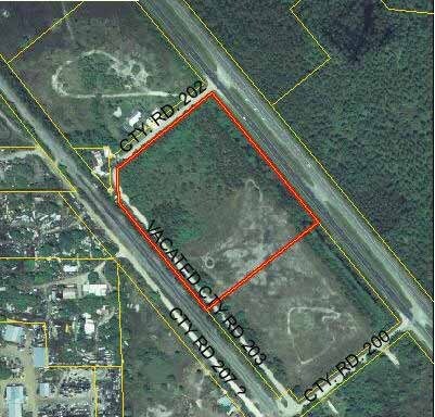
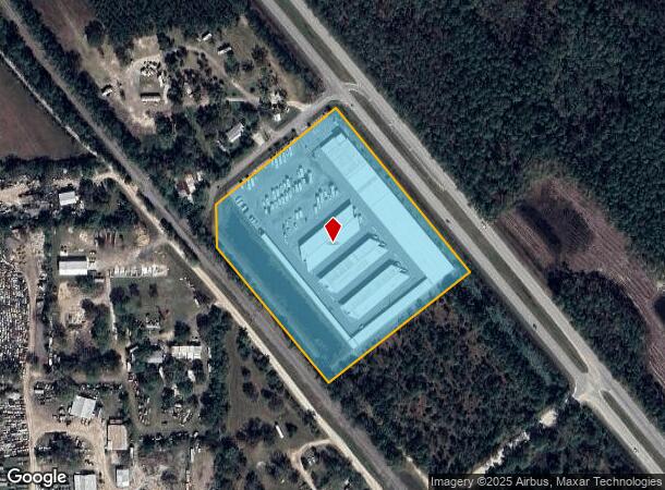
8325 S Us Highway 1 S
16-13-31-2000-00020-0000
Town Of Favoretta
Shipyard
8.37 AC TOWN OF FAVORETTA NLY 664.3 OF SLY 1174.16 BEING BOUNDED ON N BY CR 202 ON E BY U.S. #1 PARCEL INCLUDES .30 AC OF 1/2 VACATED CR 203 OR 316/ 67 OR 599/448 OR598/1841- FC RES 97-79 CLOSING PORTION CR 203 OR 1258/907 OR 1739/ 1402
X
Flagler
12035C0335E
Florida
2024
8.37 AC
2025
Daytona Area
060207
Other Market Areas
229,050 SF
Deltona-Daytona Beach-Ormond Beach, FL
DEMOGRAPHICS near 8325 S Us Highway 1 S
1 Mile
3 Mile
5 Mile
2024 Total Population
646
7,254
17,833
2029 Population
794
8,444
21,173
Pop Growth 2024-2029
+ 22.91%
+ 16.40%
+ 18.73%
Average Age
60
60
51
2024 Total Households
328
3,671
7,872
HH Growth 2024-2029
+ 21.95%
+ 16.02%
+ 17.82%
Median Household Inc
$83,991
$77,348
$73,408
Avg Household Size
2.00
1.90
2.20
2024 Avg HH Vehicles
2.00
2.00
2.00
Median Home Value
$412,000
$359,390
$318,092
Median Year Built
2003
2004
2003
Nearby Places
Map Layers
Map Styles
 Street
 Aerial
- Restaurants
- Banks
- Shops
- Fitness
- Groceries
PUBLIC TRANSPORTATION
AIRPORT
Daytona Beach International
DRIVE
WALK
Distance
Daytona Beach International
25 min
18.0 mi
SALE & LEASE HISTORY
LISTING DATE
SALE/LEASE

Sep 24, 2016
For Sale
Nov 01, 2017
For Sale
Jan 28, 2019
For Sale
Jan 27, 2019
For Sale
Jan 11, 2020
For Sale
Nearby Properties
Address
Land Use
TOTAL SIZE
Lot Size
Zoning
Address
Land Use
TOTAL SIZE
Lot Size
Zoning
209,984 SF
24.14 AC
I1
Address
Land Use
TOTAL SIZE
Lot Size
Zoning
141,982 SF
8.09 AC
C-2
Address
Land Use
TOTAL SIZE
Lot Size
Zoning
44,123 SF
139.81 AC
PUD
Address
Land Use
TOTAL SIZE
Lot Size
Zoning
400 SF
24.11 AC
PUD
Address
Land Use
TOTAL SIZE
Lot Size
Zoning
54,596 SF
7.47 AC
PUD
Address
Land Use
TOTAL SIZE
Lot Size
Zoning
3,200 SF
824.39 AC
PUD
Address
Land Use
TOTAL SIZE
Lot Size
Zoning
151,185 SF
28.90 AC
01I1
Address
Land Use
TOTAL SIZE
Lot Size
Zoning
130.59 AC
RPUD
Address
Land Use
TOTAL SIZE
Lot Size
Zoning
48.75 AC
01A2
Address
Land Use
TOTAL SIZE
Lot Size
Zoning
18,255 SF
14 AC
01I1
Address
Land Use
TOTAL SIZE
Lot Size
Zoning
51.60 AC
Address
Land Use
TOTAL SIZE
Lot Size
Zoning
9,829 SF
35.12 AC
AC
Address
Land Use
TOTAL SIZE
Lot Size
Zoning
38.93 AC
PUD
Address
Land Use
TOTAL SIZE
Lot Size
Zoning
36.68 AC
PUD
Address
Land Use
TOTAL SIZE
Lot Size
Zoning
29,729 SF
19.27 AC
AC
Address
Land Use
TOTAL SIZE
Lot Size
Zoning
37,575 SF
11.71 AC
PUD
Address
Land Use
TOTAL SIZE
Lot Size
Zoning
9,580 SF
13.25 AC
PUD
Address
Land Use
TOTAL SIZE
Lot Size
Zoning
7,117 SF
1.56 AC
PUD
Address
Land Use
TOTAL SIZE
Lot Size
Zoning
4,401 SF
1.55 AC
PUD
Address
Land Use
TOTAL SIZE
Lot Size
Zoning
3,230 SF
1.79 AC
PUD
Address
Land Use
TOTAL SIZE
Lot Size
Zoning
391 SF
19.69 AC
PUD
Address
Land Use
TOTAL SIZE
Lot Size
Zoning
13,056 SF
98.01 AC
PUD
Address
Land Use
TOTAL SIZE
Lot Size
Zoning
14,098 SF
5.32 AC
01I1
Address
Land Use
TOTAL SIZE
Lot Size
Zoning
2,364 SF
17.08 AC
MH4
Address
Land Use
TOTAL SIZE
Lot Size
Zoning
9,238 SF
1.64 AC
C-2
Address
Land Use
TOTAL SIZE
Lot Size
Zoning
19,875 SF
37.79 AC
01PUD
Address
Land Use
TOTAL SIZE
Lot Size
Zoning
34.17 AC
MPUD
Address
Land Use
TOTAL SIZE
Lot Size
Zoning
14,400 SF
3.50 AC
I-C
The World's #1 Commercial Real Estate Marketplace
Connect with us
© 2025 CoStar Group
The information above has been obtained from sources believed reliable. While we do not doubt its accuracy we have not verified it and make no guarantee, warranty or representation about it. It is your responsibility to independently confirm its accuracy and completeness. Any projections, opinions, assumptions, or estimates used are for example only and do not represent the current or future performance of the property. The value of this transaction to you depends on tax and other factors which should be evaluated by your tax, financial, and legal advisors. You and your advisors should conduct a careful, independent investigation of the property to determine to your satisfaction the suitability of the property for your needs.