Property Record
8329 W Appleton Ave, Milwaukee, WI 53218


Save to a Folder
{{folder.Name}}
{{folder.ListingIds.length}} Properties
{{folder.ListingIds.length}} Property
Create a New Folder
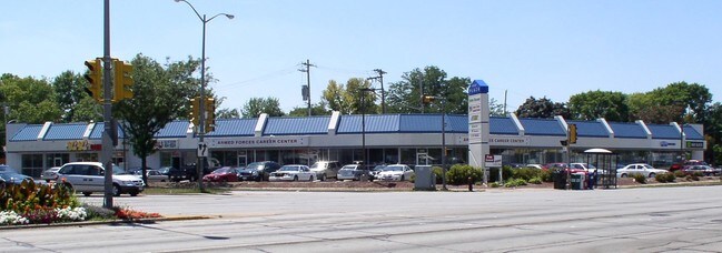
Property Detail
8329 W Appleton Ave
224-1221-000-3
CERTIFIED SURVEY MAP NO 7241 IN NW 1/4 OF NE 1/4 SEC 4-7-21 LOT 1
Regionalshoppingcenterormallwithanchorstore
MILWAUKEE
LB1
Wisconsin
B and X Area of moderate flood hazard, usually the area between the limits of the 100-year and 500-year floods.
1
2024
0.95 AC
2025
Milwaukee NW
001800
Milwaukee/Madison
14,064 SF
Milwaukee-Waukesha, WI
NEARBY LISTINGS FOR SALE OR LEASE
DEMOGRAPHICS near 8329 W Appleton Ave
1 mile
3 mile
5 mile
2025 Total Population
21,227
146,145
327,729
2030 Population
21,278
146,272
328,866
Pop Growth 2025-2030
+ 0.24%
+ 0.09%
+ 0.35%
Average Age
37
37
37
2025 Total Households
8,258
57,239
130,357
HH Growth 2025-2030
+ 0.50%
+ 0.01%
+ 0.21%
Median Household Inc
$51,500
$56,370
$58,776
Avg Household Size
2.40
2.50
2.40
2025 Avg HH Vehicles
1.00
1.00
1.00
Median Home Value
$156,876
$175,656
$208,942
Median Year Built
1958
1955
1954
Nearby Places
Map Layers
Map Styles
 Street
 Aerial
Layers
 Traffic
 Biking
Places
Listings with unknown addresses are not visible on the map
- Restaurants
- Banks
- Shops
- Fitness
- Groceries
PUBLIC TRANSPORTATION
COMMUTER RAIL
Milwaukee (Empire Builder - Amtrak)
Drive
Walk
Distance
Milwaukee (Empire Builder - Amtrak)
17 min
8.6 mi
AIRPORT
General Mitchell International
Drive
Walk
Distance
General Mitchell International
29 min
15.3 mi
Freight Ports
Port Milwaukee
Drive
Walk
Distance
Port Milwaukee
22 min
11.1 mi
SALE & LEASE HISTORY
LISTING DATE
SALE/LEASE

Sep 25, 2016
For Lease
Aug 22, 2018
For Lease
Aug 14, 2025
For Lease
Nearby Properties
Address
Land Use
TOTAL SIZE
Lot Size
Zoning
Address
Land Use
TOTAL SIZE
Lot Size
Zoning
78,185 SF
73.67 AC
M1
Address
Land Use
TOTAL SIZE
Lot Size
Zoning
1.91 AC
Address
Land Use
TOTAL SIZE
Lot Size
Zoning
28,800 SF
3.30 AC
C2
Address
Land Use
TOTAL SIZE
Lot Size
Zoning
18.95 AC
Address
Land Use
TOTAL SIZE
Lot Size
Zoning
56.46 AC
M1
Address
Land Use
TOTAL SIZE
Lot Size
Zoning
21.66 AC
M2
Address
Land Use
TOTAL SIZE
Lot Size
Zoning
2.45 AC
C2
Address
Land Use
TOTAL SIZE
Lot Size
Zoning
Address
Land Use
TOTAL SIZE
Lot Size
Zoning
0.71 AC
RM2
Address
Land Use
TOTAL SIZE
Lot Size
Zoning
8.03 AC
RM1
Address
Land Use
TOTAL SIZE
Lot Size
Zoning
16.01 AC
Address
Land Use
TOTAL SIZE
Lot Size
Zoning
Address
Land Use
TOTAL SIZE
Lot Size
Zoning
Address
Land Use
TOTAL SIZE
Lot Size
Zoning
28.28 AC
M2
Address
Land Use
TOTAL SIZE
Lot Size
Zoning
11.66 AC
C2
Address
Land Use
TOTAL SIZE
Lot Size
Zoning
221,548 SF
11.80 AC
PD
Address
Land Use
TOTAL SIZE
Lot Size
Zoning
12.49 AC
TL
Address
Land Use
TOTAL SIZE
Lot Size
Zoning
150,000 SF
12.48 AC
IL1
Address
Land Use
TOTAL SIZE
Lot Size
Zoning
18.81 AC
M2
Address
Land Use
TOTAL SIZE
Lot Size
Zoning
169,550 SF
12.04 AC
RB2
Address
Land Use
TOTAL SIZE
Lot Size
Zoning
17.84 AC
TL
Address
Land Use
TOTAL SIZE
Lot Size
Zoning
2.21 AC
C2
Address
Land Use
TOTAL SIZE
Lot Size
Zoning
6.75 AC
PUD
Address
Land Use
TOTAL SIZE
Lot Size
Zoning
8.65 AC
C2
Address
Land Use
TOTAL SIZE
Lot Size
Zoning
18.54 AC
RS6
Address
Land Use
TOTAL SIZE
Lot Size
Zoning
12.10 AC
M1
Address
Land Use
TOTAL SIZE
Lot Size
Zoning
163,539 SF
7.17 AC
PUD
Address
Land Use
TOTAL SIZE
Lot Size
Zoning
287,485 SF
11.51 AC
M1
Address
Land Use
TOTAL SIZE
Lot Size
Zoning
17.91 AC
RS5
Address
Land Use
TOTAL SIZE
Lot Size
Zoning
116,429 SF
3.49 AC
M1
The World's #1 Commercial Real Estate Marketplace
Connect with us
© 2026 CoStar Group
The information above has been obtained from sources believed reliable. While we do not doubt its accuracy we have not verified it and make no guarantee, warranty or representation about it. It is your responsibility to independently confirm its accuracy and completeness. Any projections, opinions, assumptions, or estimates used are for example only and do not represent the current or future performance of the property. The value of this transaction to you depends on tax and other factors which should be evaluated by your tax, financial, and legal advisors. You and your advisors should conduct a careful, independent investigation of the property to determine to your satisfaction the suitability of the property for your needs.