Property Record
8Th St At Nemaha St, Humboldt, NE 68376
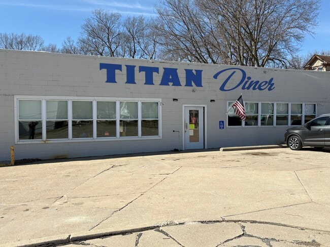
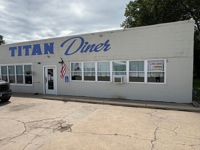
This Property Is For Sale
NEARBY LISTINGS FOR SALE OR LEASE
-
-
View all Humboldt listings for sale on LoopNet.com
Property Detail
8Th St At Nemaha St
Other Market Areas
Tl E173' S1/2 L5 B19 Kings 1St
74-0171087
HUMBOLDT KINGS 1ST BLK 19 PT S1/2 LOT 5
Commercialacreage
Richardson
X
Nebraska
31147C0175C
5
2024
0.05 AC
2025
Nebraska Area
968500
DEMOGRAPHICS near 8Th St At Nemaha St
1 Mile
3 Mile
5 Mile
2024 Total Population
865
941
1,071
2029 Population
847
921
1,048
Pop Growth 2024-2029
(2.08%)
(2.13%)
(2.15%)
Average Age
47
47
47
2024 Total Households
384
418
476
HH Growth 2024-2029
(2.34%)
(2.39%)
(2.31%)
Median Household Inc
$54,736
$54,677
$54,710
Avg Household Size
2.20
2.20
2.20
2024 Avg HH Vehicles
2.00
2.00
2.00
Median Home Value
$78,350
$78,435
$79,872
Median Year Built
1946
1946
1947
Nearby Places
Map Layers
Map Styles
 Street
 Aerial
- Restaurants
- Banks
- Shops
- Fitness
- Groceries
Nearby Properties
Address
Land Use
TOTAL SIZE
Lot Size
Zoning
Address
Land Use
TOTAL SIZE
Lot Size
Zoning
56,254 SF
2.70 AC
Address
Land Use
TOTAL SIZE
Lot Size
Zoning
31,516 SF
4.39 AC
Address
Land Use
TOTAL SIZE
Lot Size
Zoning
9,600 SF
33.40 AC
03-COMMERC
Address
Land Use
TOTAL SIZE
Lot Size
Zoning
9,000 SF
0.10 AC
03-COMMERC
Address
Land Use
TOTAL SIZE
Lot Size
Zoning
2,700 SF
01-SINGLE
Address
Land Use
TOTAL SIZE
Lot Size
Zoning
227.60 AC
05-AGRICUL
Address
Land Use
TOTAL SIZE
Lot Size
Zoning
159.75 AC
05-AGRICUL
Address
Land Use
TOTAL SIZE
Lot Size
Zoning
209.84 AC
05-AGRICUL
Address
Land Use
TOTAL SIZE
Lot Size
Zoning
19,200 SF
8.36 AC
Address
Land Use
TOTAL SIZE
Lot Size
Zoning
9,100 SF
1.97 AC
03-COMMERC
Address
Land Use
TOTAL SIZE
Lot Size
Zoning
7.05 AC
05-AGRICUL
Address
Land Use
TOTAL SIZE
Lot Size
Zoning
195.46 AC
05-AGRICUL
Address
Land Use
TOTAL SIZE
Lot Size
Zoning
80.17 AC
05-AGRICUL
Address
Land Use
TOTAL SIZE
Lot Size
Zoning
9,000 SF
0.37 AC
Address
Land Use
TOTAL SIZE
Lot Size
Zoning
131.31 AC
05-AGRICUL
Address
Land Use
TOTAL SIZE
Lot Size
Zoning
93 AC
05-AGRICUL
Address
Land Use
TOTAL SIZE
Lot Size
Zoning
80 AC
05-AGRICUL
Address
Land Use
TOTAL SIZE
Lot Size
Zoning
7,200 SF
0.27 AC
Address
Land Use
TOTAL SIZE
Lot Size
Zoning
75.14 AC
05-AGRICUL
Address
Land Use
TOTAL SIZE
Lot Size
Zoning
2,430 SF
0.12 AC
03-COMMERC
Address
Land Use
TOTAL SIZE
Lot Size
Zoning
72.97 AC
05-AGRICUL
Address
Land Use
TOTAL SIZE
Lot Size
Zoning
72.68 AC
05-AGRICUL
Address
Land Use
TOTAL SIZE
Lot Size
Zoning
5,310 SF
0.40 AC
Address
Land Use
TOTAL SIZE
Lot Size
Zoning
650 SF
0.57 AC
03-COMMERC
Address
Land Use
TOTAL SIZE
Lot Size
Zoning
80 AC
05-AGRICUL
Address
Land Use
TOTAL SIZE
Lot Size
Zoning
76.90 AC
05-AGRICUL
Address
Land Use
TOTAL SIZE
Lot Size
Zoning
3,100 SF
0.41 AC
03-COMMERC
Address
Land Use
TOTAL SIZE
Lot Size
Zoning
96.89 AC
05-AGRICUL
Address
Land Use
TOTAL SIZE
Lot Size
Zoning
740 SF
03-COMMERC
Address
Land Use
TOTAL SIZE
Lot Size
Zoning
1,270 SF
41.72 AC
05-AGRICUL
The World's #1 Commercial Real Estate Marketplace
Connect with us
© 2025 CoStar Group
The information above has been obtained from sources believed reliable. While we do not doubt its accuracy we have not verified it and make no guarantee, warranty or representation about it. It is your responsibility to independently confirm its accuracy and completeness. Any projections, opinions, assumptions, or estimates used are for example only and do not represent the current or future performance of the property. The value of this transaction to you depends on tax and other factors which should be evaluated by your tax, financial, and legal advisors. You and your advisors should conduct a careful, independent investigation of the property to determine to your satisfaction the suitability of the property for your needs.