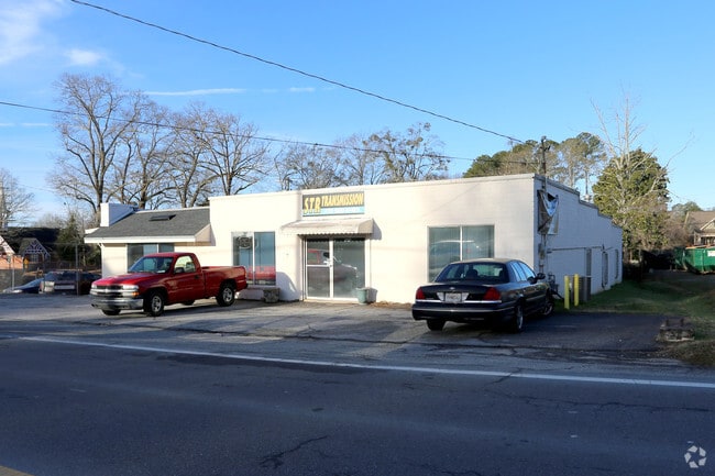
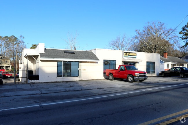
Property Record
8384 Main St, Woodstock, GA 30188

NEARBY LISTINGS FOR SALE OR LEASE
Property Detail
8384 Main St
092N03-00000-004-000-0000
LL 1022; 15TH D PB2 PG 70
Warehouse
Cherokee
X
Georgia
13057C0332E
0.22 AC
2025
Cherokee/Woodstock
2025
Atlanta
091001
Atlanta-Sandy Springs-Roswell, GA
4,923 SF
DEMOGRAPHICS near 8384 Main St
1 Mile
3 Mile
5 Mile
2024 Total Population
11,224
67,774
169,654
2029 Population
12,897
76,801
188,097
Pop Growth 2024-2029
+ 14.91%
+ 13.32%
+ 10.87%
Average Age
39
40
40
2024 Total Households
4,698
25,875
61,901
HH Growth 2024-2029
+ 15.20%
+ 13.55%
+ 11.19%
Median Household Inc
$74,377
$91,184
$98,266
Avg Household Size
2.30
2.60
2.70
2024 Avg HH Vehicles
2.00
2.00
2.00
Median Home Value
$446,551
$327,530
$334,628
Median Year Built
2006
1998
1993
Nearby Places
- Restaurants
- Banks
- Shops
- Fitness
- Groceries
SALE & LEASE HISTORY
LISTING DATE
SALE/LEASE

Jun 19, 2017
For Lease
Nearby Properties
Address
Land Use
TOTAL SIZE
Lot Size
Zoning
Address
Land Use
TOTAL SIZE
Lot Size
Zoning
523,803 SF
148.37 AC
R-40
Address
Land Use
TOTAL SIZE
Lot Size
Zoning
228,644 SF
7.88 AC
DT-CBD
Address
Land Use
TOTAL SIZE
Lot Size
Zoning
309,011 SF
64.20 AC
PUD
Address
Land Use
TOTAL SIZE
Lot Size
Zoning
197,890 SF
14.60 AC
R-4
Address
Land Use
TOTAL SIZE
Lot Size
Zoning
604,056 SF
25.03 AC
R-40
Address
Land Use
TOTAL SIZE
Lot Size
Zoning
181,704 SF
17.56 AC
DT-MRA
Address
Land Use
TOTAL SIZE
Lot Size
Zoning
349,911 SF
18.11 AC
LI
Address
Land Use
TOTAL SIZE
Lot Size
Zoning
399,085 SF
38.48 AC
LI
Address
Land Use
TOTAL SIZE
Lot Size
Zoning
157,013 SF
18.53 AC
IN-VIL
Address
Land Use
TOTAL SIZE
Lot Size
Zoning
128,196 SF
24.68 AC
R-4
Address
Land Use
TOTAL SIZE
Lot Size
Zoning
266,487 SF
21.69 AC
R-4
Address
Land Use
TOTAL SIZE
Lot Size
Zoning
120,084 SF
25.15 AC
LI
Address
Land Use
TOTAL SIZE
Lot Size
Zoning
188,105 SF
25.86 AC
R-5
Address
Land Use
TOTAL SIZE
Lot Size
Zoning
328,203 SF
71 AC
R-40
Address
Land Use
TOTAL SIZE
Lot Size
Zoning
346,900 SF
104.10 AC
CD
Address
Land Use
TOTAL SIZE
Lot Size
Zoning
235,861 SF
31.92 AC
RM10
Address
Land Use
TOTAL SIZE
Lot Size
Zoning
238,600 SF
21.10 AC
R-3
Address
Land Use
TOTAL SIZE
Lot Size
Zoning
91,547 SF
18.48 AC
R-3
Address
Land Use
TOTAL SIZE
Lot Size
Zoning
189,456 SF
28.35 AC
NC-TCT
Address
Land Use
TOTAL SIZE
Lot Size
Zoning
113,849 SF
7.46 AC
R-5
Address
Land Use
TOTAL SIZE
Lot Size
Zoning
186,426 SF
32.52 AC
NC-TCT
Address
Land Use
TOTAL SIZE
Lot Size
Zoning
161,310 SF
34.63 AC
R-40
Address
Land Use
TOTAL SIZE
Lot Size
Zoning
85,166 SF
3.41 AC
DT-CBD
Address
Land Use
TOTAL SIZE
Lot Size
Zoning
186,090 SF
30.08 AC
GC
Address
Land Use
TOTAL SIZE
Lot Size
Zoning
63,264 SF
8 AC
PUD
Address
Land Use
TOTAL SIZE
Lot Size
Zoning
132,022 SF
12.69 AC
GC
Address
Land Use
TOTAL SIZE
Lot Size
Zoning
86,307 SF
13.49 AC
GC
Address
Land Use
TOTAL SIZE
Lot Size
Zoning
156,752 SF
16.34 AC
NC-TCT
Address
Land Use
TOTAL SIZE
Lot Size
Zoning
89,552 SF
14.69 AC
DT-MR
Address
Land Use
TOTAL SIZE
Lot Size
Zoning
52,703 SF
37.65 AC
LI
The World's #1 Commercial Real Estate Marketplace
Connect with us
© 2025 CoStar Group
The information above has been obtained from sources believed reliable. While we do not doubt its accuracy we have not verified it and make no guarantee, warranty or representation about it. It is your responsibility to independently confirm its accuracy and completeness. Any projections, opinions, assumptions, or estimates used are for example only and do not represent the current or future performance of the property. The value of this transaction to you depends on tax and other factors which should be evaluated by your tax, financial, and legal advisors. You and your advisors should conduct a careful, independent investigation of the property to determine to your satisfaction the suitability of the property for your needs.