Property Record
8345 Main St, Mokelumne Hill, CA 95245
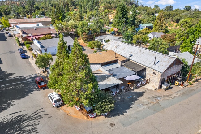

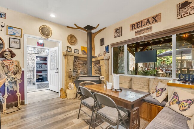
This Property Is For Sale
NEARBY LISTINGS FOR SALE OR LEASE
-
-
View all Mokelumne Hill listings for sale on LoopNet.com
Property Detail
8345 Main St
018-007-008-000
Moke Hill Twst
Restaurantbuilding
MOKE HILL TWST LOTS 1 8 PORSLOTS 2 3 9 11 BLK
X
Calaveras
06009C0225E
California
2025
1
2025
0.11 AC
000301
Merced/Central
1,350 SF
Other Market Areas
DEMOGRAPHICS near 8345 Main St
1 Mile
3 Mile
5 Mile
2024 Total Population
715
1,109
4,931
2029 Population
698
1,094
4,962
Pop Growth 2024-2029
(2.38%)
(1.35%)
+ 0.63%
Average Age
47
48
47
2024 Total Households
306
481
2,137
HH Growth 2024-2029
(2.61%)
(1.25%)
+ 0.66%
Median Household Inc
$57,028
$60,577
$84,618
Avg Household Size
2.20
2.20
2.30
2024 Avg HH Vehicles
2.00
2.00
2.00
Median Home Value
$495,237
$518,293
$508,296
Median Year Built
1982
1981
1980
Nearby Places
Map Layers
Map Styles
 Street
 Aerial
- Restaurants
- Banks
- Shops
- Fitness
- Groceries
Nearby Properties
Address
Land Use
TOTAL SIZE
Lot Size
Zoning
Address
Land Use
TOTAL SIZE
Lot Size
Zoning
20,610 SF
22.66 AC
R1A
Address
Land Use
TOTAL SIZE
Lot Size
Zoning
3,510 SF
15.57 AC
C1PDRR1
Address
Land Use
TOTAL SIZE
Lot Size
Zoning
2.80 AC
C2PD
Address
Land Use
TOTAL SIZE
Lot Size
Zoning
5,505 SF
406.39 AC
AG
Address
Land Use
TOTAL SIZE
Lot Size
Zoning
2,816 SF
0.57 AC
C2PD
Address
Land Use
TOTAL SIZE
Lot Size
Zoning
1,440 SF
126.82 AC
A140
Address
Land Use
TOTAL SIZE
Lot Size
Zoning
3,398 SF
10.47 AC
RR1
Address
Land Use
TOTAL SIZE
Lot Size
Zoning
3,600 SF
4.39 AC
RR3
Address
Land Use
TOTAL SIZE
Lot Size
Zoning
1,389 SF
13.06 AC
RA13
Address
Land Use
TOTAL SIZE
Lot Size
Zoning
2,727 SF
23.68 AC
RR1
Address
Land Use
TOTAL SIZE
Lot Size
Zoning
11,560 SF
0.98 AC
C2PD
Address
Land Use
TOTAL SIZE
Lot Size
Zoning
2,812 SF
5.01 AC
RR1
Address
Land Use
TOTAL SIZE
Lot Size
Zoning
2,604 SF
40 AC
R1A
Address
Land Use
TOTAL SIZE
Lot Size
Zoning
3,000 SF
0.78 AC
R36PD
Address
Land Use
TOTAL SIZE
Lot Size
Zoning
2.68 AC
C2PD
Address
Land Use
TOTAL SIZE
Lot Size
Zoning
3,044 SF
14.45 AC
AP
Address
Land Use
TOTAL SIZE
Lot Size
Zoning
2,824 SF
11.52 AC
RR1
Address
Land Use
TOTAL SIZE
Lot Size
Zoning
2,184 SF
8.62 AC
RA
Address
Land Use
TOTAL SIZE
Lot Size
Zoning
6,522 SF
10.37 AC
RR1
Address
Land Use
TOTAL SIZE
Lot Size
Zoning
2,006 SF
6.61 AC
RR3
Address
Land Use
TOTAL SIZE
Lot Size
Zoning
1,770 SF
47.83 AC
A
Address
Land Use
TOTAL SIZE
Lot Size
Zoning
2,485 SF
5.01 AC
RR1
Address
Land Use
TOTAL SIZE
Lot Size
Zoning
4,032 SF
1.78 AC
RR1
Address
Land Use
TOTAL SIZE
Lot Size
Zoning
1,240 SF
6.96 AC
U
Address
Land Use
TOTAL SIZE
Lot Size
Zoning
1,455 SF
120 AC
AG
Address
Land Use
TOTAL SIZE
Lot Size
Zoning
77.33 AC
RR1
Address
Land Use
TOTAL SIZE
Lot Size
Zoning
2,160 SF
11.19 AC
U
Address
Land Use
TOTAL SIZE
Lot Size
Zoning
2,420 SF
20.97 AC
AP
Address
Land Use
TOTAL SIZE
Lot Size
Zoning
1,903 SF
48.93 AC
U
Address
Land Use
TOTAL SIZE
Lot Size
Zoning
2,248 SF
6.10 AC
RR05
The World's #1 Commercial Real Estate Marketplace
Connect with us
© 2025 CoStar Group
The information above has been obtained from sources believed reliable. While we do not doubt its accuracy we have not verified it and make no guarantee, warranty or representation about it. It is your responsibility to independently confirm its accuracy and completeness. Any projections, opinions, assumptions, or estimates used are for example only and do not represent the current or future performance of the property. The value of this transaction to you depends on tax and other factors which should be evaluated by your tax, financial, and legal advisors. You and your advisors should conduct a careful, independent investigation of the property to determine to your satisfaction the suitability of the property for your needs.