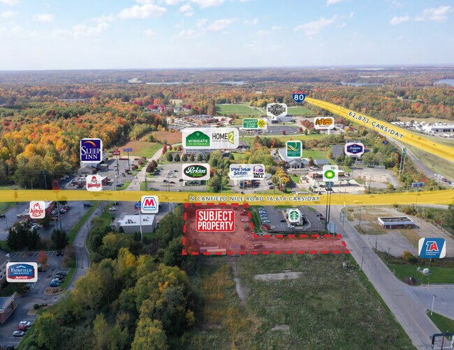
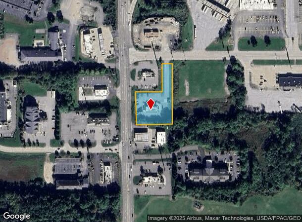
Property Record
835 N Canfield Niles Rd, Youngstown, OH 44515
NEARBY LISTINGS FOR SALE OR LEASE
Property Detail
835 N Canfield Niles Rd
Youngstown/Warren/Boardman
Blaze Plat No 1
Youngstown-Warren-Boardman, OH-PA
LOT 1 60.00 X 361.36 (IRR) BLAZE PLAT NO 1
48-090-0-008.02-0
Mahoning
Restaurantdrivein
Ohio
2024
1
2024
1.21 AC
812500
Mahoning County
2,338 SF
DEMOGRAPHICS near 835 N Canfield Niles Rd
1 Mile
3 Mile
5 Mile
2024 Total Population
1,495
24,082
81,207
2029 Population
1,483
23,516
79,728
Pop Growth 2024-2029
(0.80%)
(2.35%)
(1.82%)
Average Age
46
44
43
2024 Total Households
565
10,996
35,898
HH Growth 2024-2029
(0.88%)
(2.53%)
(1.94%)
Median Household Inc
$63,136
$51,885
$49,402
Avg Household Size
2.40
2.10
2.20
2024 Avg HH Vehicles
2.00
2.00
2.00
Median Home Value
$154,923
$138,617
$111,685
Median Year Built
1978
1967
1961
Nearby Places
Map Layers
Map Styles
 Street
 Aerial
- Restaurants
- Banks
- Shops
- Fitness
- Groceries
SALE & LEASE HISTORY
LISTING DATE
SALE/LEASE

Oct 25, 2022
For Sale
Nearby Properties
Address
Land Use
TOTAL SIZE
Lot Size
Zoning
Address
Land Use
TOTAL SIZE
Lot Size
Zoning
178,531 SF
189.16 AC
Address
Land Use
TOTAL SIZE
Lot Size
Zoning
1,582.88 AC
Address
Land Use
TOTAL SIZE
Lot Size
Zoning
188,134 SF
12.60 AC
R1
Address
Land Use
TOTAL SIZE
Lot Size
Zoning
127,210 SF
12.43 AC
R1
Address
Land Use
TOTAL SIZE
Lot Size
Zoning
122,806 SF
9.46 AC
R1
Address
Land Use
TOTAL SIZE
Lot Size
Zoning
Address
Land Use
TOTAL SIZE
Lot Size
Zoning
324,442 SF
54 AC
R1
Address
Land Use
TOTAL SIZE
Lot Size
Zoning
14.92 AC
Address
Land Use
TOTAL SIZE
Lot Size
Zoning
70,642 SF
34.06 AC
ASER
Address
Land Use
TOTAL SIZE
Lot Size
Zoning
98,609 SF
11.01 AC
Address
Land Use
TOTAL SIZE
Lot Size
Zoning
54,767 SF
16 AC
B2
Address
Land Use
TOTAL SIZE
Lot Size
Zoning
470,857 SF
18.81 AC
I2
Address
Land Use
TOTAL SIZE
Lot Size
Zoning
123,472 SF
28.58 AC
R3
Address
Land Use
TOTAL SIZE
Lot Size
Zoning
58,282 SF
24.96 AC
Address
Land Use
TOTAL SIZE
Lot Size
Zoning
70,544 SF
7.62 AC
B2
Address
Land Use
TOTAL SIZE
Lot Size
Zoning
71,678 SF
7.78 AC
Address
Land Use
TOTAL SIZE
Lot Size
Zoning
95,231 SF
37.75 AC
ASER
Address
Land Use
TOTAL SIZE
Lot Size
Zoning
382,202 SF
18.29 AC
I2
Address
Land Use
TOTAL SIZE
Lot Size
Zoning
81,954 SF
15 AC
R3
Address
Land Use
TOTAL SIZE
Lot Size
Zoning
23,603 SF
8.87 AC
B2
Address
Land Use
TOTAL SIZE
Lot Size
Zoning
114,617 SF
18.07 AC
B2
Address
Land Use
TOTAL SIZE
Lot Size
Zoning
70,713 SF
7.73 AC
B2
Address
Land Use
TOTAL SIZE
Lot Size
Zoning
58,663 SF
24.53 AC
ASER
Address
Land Use
TOTAL SIZE
Lot Size
Zoning
Address
Land Use
TOTAL SIZE
Lot Size
Zoning
315,482 SF
33.17 AC
I2
Address
Land Use
TOTAL SIZE
Lot Size
Zoning
43,927 SF
13.92 AC
R3
Address
Land Use
TOTAL SIZE
Lot Size
Zoning
58,085 SF
3.31 AC
I2
Address
Land Use
TOTAL SIZE
Lot Size
Zoning
57,318 SF
3.01 AC
B2
Address
Land Use
TOTAL SIZE
Lot Size
Zoning
13,667 SF
7.29 AC
B1
Address
Land Use
TOTAL SIZE
Lot Size
Zoning
11,472 SF
11 AC
R3
The World's #1 Commercial Real Estate Marketplace
Connect with us
© 2025 CoStar Group
The information above has been obtained from sources believed reliable. While we do not doubt its accuracy we have not verified it and make no guarantee, warranty or representation about it. It is your responsibility to independently confirm its accuracy and completeness. Any projections, opinions, assumptions, or estimates used are for example only and do not represent the current or future performance of the property. The value of this transaction to you depends on tax and other factors which should be evaluated by your tax, financial, and legal advisors. You and your advisors should conduct a careful, independent investigation of the property to determine to your satisfaction the suitability of the property for your needs.