Property Record
835 E Nuevo Rd, Perris, CA 92571


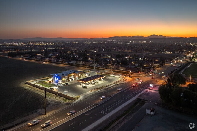
Property Detail
835 E Nuevo Rd
310-180-056
ACRES 2.35000000 ACREAGEQUALCODE ML
Servicestation
RIVERSIDE
AE The base floodplain where base flood elevations are provided. AE Zones are now used on new format FIRMs instead of A1-A30 Zones.
California
2024
2.35 AC
2025
Moreno Valley/Perris
042747
Inland Empire (California)
7,250 SF
Riverside-San Bernardino-Ontario, CA
NEARBY LISTINGS FOR SALE OR LEASE
DEMOGRAPHICS near 835 E Nuevo Rd
1 mile
3 mile
5 mile
2025 Total Population
24,799
74,453
110,688
2030 Population
25,522
76,357
113,616
Pop Growth 2025-2030
+ 2.92%
+ 2.56%
+ 2.65%
Average Age
33
33
34
2025 Total Households
5,787
17,713
26,919
HH Growth 2025-2030
+ 2.78%
+ 2.34%
+ 2.50%
Median Household Inc
$81,764
$82,577
$84,934
Avg Household Size
4.10
4.00
3.90
2025 Avg HH Vehicles
2.00
3.00
3.00
Median Home Value
$449,288
$464,359
$477,736
Median Year Built
1995
1996
1996
Nearby Places
Map Layers
Map Styles
 Street
 Aerial
Layers
 Traffic
 Biking
Places
Listings with unknown addresses are not visible on the map
- Restaurants
- Banks
- Shops
- Fitness
- Groceries
PUBLIC TRANSPORTATION
COMMUTER RAIL
Drive
Walk
Distance
5 min
2.4 mi
Drive
Walk
Distance
7 min
3.7 mi
AIRPORT
Ontario International
Drive
Walk
Distance
Ontario International
43 min
34.1 mi
Nearby Properties
Address
Land Use
TOTAL SIZE
Lot Size
Zoning
Address
Land Use
TOTAL SIZE
Lot Size
Zoning
1,189,664 SF
55.26 AC
Address
Land Use
TOTAL SIZE
Lot Size
Zoning
1,224,874 SF
59.05 AC
Address
Land Use
TOTAL SIZE
Lot Size
Zoning
783,407 SF
36.72 AC
Address
Land Use
TOTAL SIZE
Lot Size
Zoning
1,309,754 SF
57.79 AC
IL
Address
Land Use
TOTAL SIZE
Lot Size
Zoning
343 SF
83.52 AC
LI
Address
Land Use
TOTAL SIZE
Lot Size
Zoning
678,087 SF
30.24 AC
Address
Land Use
TOTAL SIZE
Lot Size
Zoning
325,560 SF
16.65 AC
Address
Land Use
TOTAL SIZE
Lot Size
Zoning
355,031 SF
16.29 AC
LI
Address
Land Use
TOTAL SIZE
Lot Size
Zoning
426,546 SF
14.78 AC
LI
Address
Land Use
TOTAL SIZE
Lot Size
Zoning
302,333 SF
15.60 AC
LI
Address
Land Use
TOTAL SIZE
Lot Size
Zoning
202,538 SF
9.58 AC
Address
Land Use
TOTAL SIZE
Lot Size
Zoning
429,823 SF
20.07 AC
Address
Land Use
TOTAL SIZE
Lot Size
Zoning
324,382 SF
16.25 AC
Address
Land Use
TOTAL SIZE
Lot Size
Zoning
18,121 SF
15.15 AC
Address
Land Use
TOTAL SIZE
Lot Size
Zoning
248,483 SF
Address
Land Use
TOTAL SIZE
Lot Size
Zoning
274,010 SF
11.19 AC
RA
Address
Land Use
TOTAL SIZE
Lot Size
Zoning
274,009 SF
10.80 AC
RA
Address
Land Use
TOTAL SIZE
Lot Size
Zoning
28.13 AC
RR
Address
Land Use
TOTAL SIZE
Lot Size
Zoning
197,865 SF
10.74 AC
Address
Land Use
TOTAL SIZE
Lot Size
Zoning
34.84 AC
Address
Land Use
TOTAL SIZE
Lot Size
Zoning
57,600 SF
51.69 AC
Address
Land Use
TOTAL SIZE
Lot Size
Zoning
85,727 SF
9.87 AC
MH
Address
Land Use
TOTAL SIZE
Lot Size
Zoning
154,559 SF
9.69 AC
Address
Land Use
TOTAL SIZE
Lot Size
Zoning
131,675 SF
7.47 AC
Address
Land Use
TOTAL SIZE
Lot Size
Zoning
6.99 AC
MIX
Address
Land Use
TOTAL SIZE
Lot Size
Zoning
187,889 SF
20.64 AC
Address
Land Use
TOTAL SIZE
Lot Size
Zoning
32,709 SF
4.61 AC
C2
Address
Land Use
TOTAL SIZE
Lot Size
Zoning
246,160 SF
19.25 AC
LI
The World's #1 Commercial Real Estate Marketplace
Connect with us
© 2026 CoStar Group
The information above has been obtained from sources believed reliable. While we do not doubt its accuracy we have not verified it and make no guarantee, warranty or representation about it. It is your responsibility to independently confirm its accuracy and completeness. Any projections, opinions, assumptions, or estimates used are for example only and do not represent the current or future performance of the property. The value of this transaction to you depends on tax and other factors which should be evaluated by your tax, financial, and legal advisors. You and your advisors should conduct a careful, independent investigation of the property to determine to your satisfaction the suitability of the property for your needs.