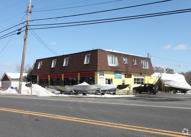
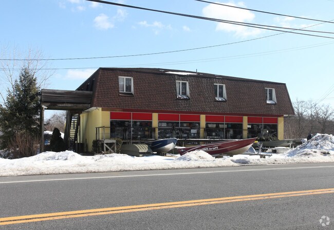
Property Record
835 Flatbush Rd, Kingston, NY 12401

Property Detail
835 Flatbush Rd
5400-048.012-0002-006.000-0000
Ulster
Vehiclerentalsvehiclesales
New York
37
6.000
B and X Area of moderate flood hazard, usually the area between the limits of the 100-year and 500-year floods.
1.10 AC
2025
Newburgh/Kingston
2025
Other Market Areas
951400
Kingston, NY
8,534 SF
NEARBY LISTINGS FOR SALE OR LEASE
DEMOGRAPHICS near 835 Flatbush Rd
1 mile
3 mile
5 mile
2025 Total Population
359
18,275
49,752
2030 Population
358
18,078
49,239
Pop Growth 2025-2030
(0.28%)
(1.08%)
(1.03%)
Average Age
49
43
44
2025 Total Households
188
7,566
21,139
HH Growth 2025-2030
0.00%
(1.00%)
(1.07%)
Median Household Inc
$65,000
$75,020
$79,807
Avg Household Size
1.90
2.20
2.20
2025 Avg HH Vehicles
1.00
2.00
2.00
Median Home Value
$201,562
$284,231
$344,858
Median Year Built
1992
1955
1958
Nearby Places
Map Layers
Map Styles
 Street
 Aerial
Layers
 Traffic
 Biking
Places
Listings with unknown addresses are not visible on the map
- Restaurants
- Banks
- Shops
- Fitness
- Groceries
PUBLIC TRANSPORTATION
COMMUTER RAIL
Drive
Walk
Distance
15 min
7.9 mi
AIRPORT
New York Stewart International
Drive
Walk
Distance
New York Stewart International
57 min
42.4 mi
Freight Ports
Albany, NY Port
Drive
Walk
Distance
Albany, NY Port
68 min
51.0 mi
Nearby Properties
Address
Land Use
TOTAL SIZE
Lot Size
Zoning
Address
Land Use
TOTAL SIZE
Lot Size
Zoning
820,644 SF
36.70 AC
HP20
Address
Land Use
TOTAL SIZE
Lot Size
Zoning
21.40 AC
R-1
Address
Land Use
TOTAL SIZE
Lot Size
Zoning
80,640 SF
6.10 AC
37
Address
Land Use
TOTAL SIZE
Lot Size
Zoning
198,029 SF
14.10 AC
37
Address
Land Use
TOTAL SIZE
Lot Size
Zoning
181,151 SF
4.90 AC
SD
Address
Land Use
TOTAL SIZE
Lot Size
Zoning
425,087 SF
16.10 AC
36
Address
Land Use
TOTAL SIZE
Lot Size
Zoning
142,823 SF
47.67 AC
33
Address
Land Use
TOTAL SIZE
Lot Size
Zoning
109,860 SF
8.60 AC
35
Address
Land Use
TOTAL SIZE
Lot Size
Zoning
Address
Land Use
TOTAL SIZE
Lot Size
Zoning
16,933 SF
14.90 AC
SD
Address
Land Use
TOTAL SIZE
Lot Size
Zoning
67,180 SF
2.60 AC
T5MS
Address
Land Use
TOTAL SIZE
Lot Size
Zoning
205,740 SF
15 AC
36
Address
Land Use
TOTAL SIZE
Lot Size
Zoning
120 SF
56.32 AC
35
Address
Land Use
TOTAL SIZE
Lot Size
Zoning
116,744 SF
12.40 AC
33
Address
Land Use
TOTAL SIZE
Lot Size
Zoning
67,566 SF
2.90 AC
T5N
Address
Land Use
TOTAL SIZE
Lot Size
Zoning
12.70 AC
36
Address
Land Use
TOTAL SIZE
Lot Size
Zoning
129,612 SF
11.30 AC
36
Address
Land Use
TOTAL SIZE
Lot Size
Zoning
135,674 SF
13.90 AC
36
Address
Land Use
TOTAL SIZE
Lot Size
Zoning
6,000 SF
6.40 AC
SD
Address
Land Use
TOTAL SIZE
Lot Size
Zoning
5,488 SF
15 AC
33
Address
Land Use
TOTAL SIZE
Lot Size
Zoning
65,640 SF
18.30 AC
35
Address
Land Use
TOTAL SIZE
Lot Size
Zoning
53,839 SF
3 AC
36
Address
Land Use
TOTAL SIZE
Lot Size
Zoning
88,000 SF
8.90 AC
36
Address
Land Use
TOTAL SIZE
Lot Size
Zoning
123,455 SF
8.70 AC
36
Address
Land Use
TOTAL SIZE
Lot Size
Zoning
115,834 SF
11.70 AC
36
Address
Land Use
TOTAL SIZE
Lot Size
Zoning
62,224 SF
3.30 AC
36
Address
Land Use
TOTAL SIZE
Lot Size
Zoning
60,105 SF
11.50 AC
36
Address
Land Use
TOTAL SIZE
Lot Size
Zoning
7,259 SF
134.70 AC
HP20
Address
Land Use
TOTAL SIZE
Lot Size
Zoning
76,911 SF
1.60 AC
T5F
Address
Land Use
TOTAL SIZE
Lot Size
Zoning
640 SF
2.60 AC
T3L
The World's #1 Commercial Real Estate Marketplace
Connect with us
© 2026 CoStar Group
The information above has been obtained from sources believed reliable. While we do not doubt its accuracy we have not verified it and make no guarantee, warranty or representation about it. It is your responsibility to independently confirm its accuracy and completeness. Any projections, opinions, assumptions, or estimates used are for example only and do not represent the current or future performance of the property. The value of this transaction to you depends on tax and other factors which should be evaluated by your tax, financial, and legal advisors. You and your advisors should conduct a careful, independent investigation of the property to determine to your satisfaction the suitability of the property for your needs.