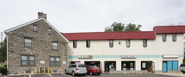
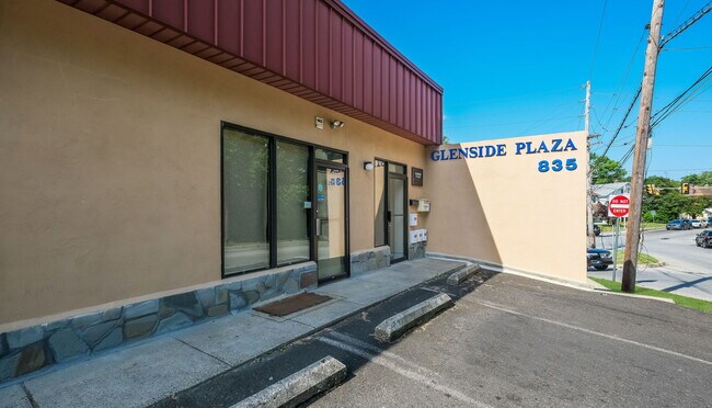
Property Record
835 Glenside Ave, Wyncote, PA 19095


Save to a Folder
{{folder.Name}}
{{folder.ListingIds.length}} Properties
{{folder.ListingIds.length}} Property
Create a New Folder
Property Detail
835 Glenside Ave
31-00-11644-007
RENOVATIONS TO OFFICES,STORES
Commercialnec
MONTGOMERY
G
Pennsylvania
AE The base floodplain where base flood elevations are provided. AE Zones are now used on new format FIRMs instead of A1-A30 Zones.
21
2026
0.48 AC
2026
Horsham/Willow Grove
202602
Philadelphia
16,730 SF
Philadelphia-Camden-Wilmington, PA-NJ-DE-MD
NEARBY LISTINGS FOR SALE OR LEASE
DEMOGRAPHICS near 835 Glenside Ave
1 mile
3 mile
5 mile
2025 Total Population
19,986
152,041
426,505
2030 Population
20,810
153,068
424,980
Pop Growth 2025-2030
+ 4.12%
+ 0.68%
(0.36%)
Average Age
42
42
42
2025 Total Households
7,962
60,298
167,117
HH Growth 2025-2030
+ 4.53%
+ 0.68%
(0.44%)
Median Household Inc
$106,925
$84,797
$72,124
Avg Household Size
2.40
2.40
2.40
2025 Avg HH Vehicles
2.00
2.00
1.00
Median Home Value
$435,484
$350,100
$310,760
Median Year Built
1950
1953
1952
Nearby Places
Map Layers
Map Styles
 Street
 Aerial
Layers
 Traffic
 Biking
Places
Listings with unknown addresses are not visible on the map
- Restaurants
- Banks
- Shops
- Fitness
- Groceries
PUBLIC TRANSPORTATION
COMMUTER RAIL
Glenside (R1 - Southeastern Pennsylvania Transportation Authority Regional Rail (SEPTA Regional Rail), R2 - Southeastern Pennsylvania Transportation Authority Regional Rail (SEPTA Regional Rail), R5 - Southeastern Pennsylvania Transportation Authority Regional Rail (SEPTA Regional Rail))
Drive
Walk
Distance
Glenside (R1 - Southeastern Pennsylvania Transportation Authority Regional Rail (SEPTA Regional Rail), R2 - Southeastern Pennsylvania Transportation Authority Regional Rail (SEPTA Regional Rail), R5 - Southeastern Pennsylvania Transportation Authority Regional Rail (SEPTA Regional Rail))
2 min
11 min
0.6 mi
Jenkintown-Wyncote (R1 - Southeastern Pennsylvania Transportation Authority Regional Rail (SEPTA Regional Rail), R2 - Southeastern Pennsylvania Transportation Authority Regional Rail (SEPTA Regional Rail), R3 - Southeastern Pennsylvania Transportation Authority Regional Rail (SEPTA Regional Rail), R5 - Southeastern Pennsylvania Transportation Authority Regional Rail (SEPTA Regional Rail))
Drive
Walk
Distance
Jenkintown-Wyncote (R1 - Southeastern Pennsylvania Transportation Authority Regional Rail (SEPTA Regional Rail), R2 - Southeastern Pennsylvania Transportation Authority Regional Rail (SEPTA Regional Rail), R3 - Southeastern Pennsylvania Transportation Authority Regional Rail (SEPTA Regional Rail), R5 - Southeastern Pennsylvania Transportation Authority Regional Rail (SEPTA Regional Rail))
3 min
13 min
0.7 mi
AIRPORT
Philadelphia International
Drive
Walk
Distance
Philadelphia International
41 min
22.7 mi
Trenton Mercer
Drive
Walk
Distance
Trenton Mercer
46 min
25.9 mi
Freight Ports
Port of Philadelphia
Drive
Walk
Distance
Port of Philadelphia
19 min
11.1 mi
SALE & LEASE HISTORY
LISTING DATE
SALE/LEASE

May 15, 2017
For Lease
May 11, 2018
For Sale
Jun 28, 2024
For Sale
Jul 24, 2017
For Sale
Aug 12, 2021
For Lease
Nearby Properties
Address
Land Use
TOTAL SIZE
Lot Size
Zoning
Address
Land Use
TOTAL SIZE
Lot Size
Zoning
1,556,628 SF
7.70 AC
AO
Address
Land Use
TOTAL SIZE
Lot Size
Zoning
2,146,150 SF
119.95 AC
M1
Address
Land Use
TOTAL SIZE
Lot Size
Zoning
662,450 SF
55.03 AC
R1
Address
Land Use
TOTAL SIZE
Lot Size
Zoning
487,936 SF
58.50 AC
T
Address
Land Use
TOTAL SIZE
Lot Size
Zoning
705,687 SF
19.89 AC
C1
Address
Land Use
TOTAL SIZE
Lot Size
Zoning
334,265 SF
44.56 AC
INST
Address
Land Use
TOTAL SIZE
Lot Size
Zoning
263,000 SF
5.31 AC
RM2
Address
Land Use
TOTAL SIZE
Lot Size
Zoning
239,971 SF
43.63 AC
AA
Address
Land Use
TOTAL SIZE
Lot Size
Zoning
635,387 SF
10.12 AC
C1
Address
Land Use
TOTAL SIZE
Lot Size
Zoning
316,163 SF
45.32 AC
T
Address
Land Use
TOTAL SIZE
Lot Size
Zoning
557,091 SF
21.87 AC
AO
Address
Land Use
TOTAL SIZE
Lot Size
Zoning
222,235 SF
29.23 AC
A
Address
Land Use
TOTAL SIZE
Lot Size
Zoning
582,294 SF
9.07 AC
C1
Address
Land Use
TOTAL SIZE
Lot Size
Zoning
615,217 SF
33.52 AC
C2
Address
Land Use
TOTAL SIZE
Lot Size
Zoning
182,130 SF
6.45 AC
RSA3
Address
Land Use
TOTAL SIZE
Lot Size
Zoning
336,650 SF
61.74 AC
R3
Address
Land Use
TOTAL SIZE
Lot Size
Zoning
435,888 SF
16.35 AC
MD
Address
Land Use
TOTAL SIZE
Lot Size
Zoning
167,743 SF
20.70 AC
T
Address
Land Use
TOTAL SIZE
Lot Size
Zoning
232,190 SF
34.16 AC
R4
Address
Land Use
TOTAL SIZE
Lot Size
Zoning
299,202 SF
42.19 AC
V
Address
Land Use
TOTAL SIZE
Lot Size
Zoning
139,087 SF
2.76 AC
V
Address
Land Use
TOTAL SIZE
Lot Size
Zoning
232,000 SF
13.71 AC
RSA3
Address
Land Use
TOTAL SIZE
Lot Size
Zoning
206,934 SF
32.50 AC
NR
Address
Land Use
TOTAL SIZE
Lot Size
Zoning
566,988 SF
29.69 AC
C2
Address
Land Use
TOTAL SIZE
Lot Size
Zoning
574,944 SF
5.45 AC
F2
Address
Land Use
TOTAL SIZE
Lot Size
Zoning
336,463 SF
7.52 AC
Address
Land Use
TOTAL SIZE
Lot Size
Zoning
250,749 SF
47.90 AC
V
Address
Land Use
TOTAL SIZE
Lot Size
Zoning
160,029 SF
28.56 AC
R3
Address
Land Use
TOTAL SIZE
Lot Size
Zoning
130,115 SF
10.45 AC
PB
Address
Land Use
TOTAL SIZE
Lot Size
Zoning
326,786 SF
5.32 AC
AO
The World's #1 Commercial Real Estate Marketplace
Connect with us
© 2026 CoStar Group
The information above has been obtained from sources believed reliable. While we do not doubt its accuracy we have not verified it and make no guarantee, warranty or representation about it. It is your responsibility to independently confirm its accuracy and completeness. Any projections, opinions, assumptions, or estimates used are for example only and do not represent the current or future performance of the property. The value of this transaction to you depends on tax and other factors which should be evaluated by your tax, financial, and legal advisors. You and your advisors should conduct a careful, independent investigation of the property to determine to your satisfaction the suitability of the property for your needs.