Property Record
835 Mathew St, Santa Clara, CA 95050
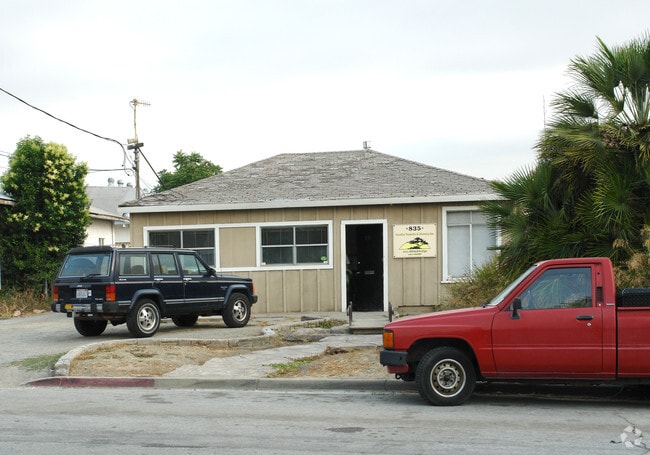
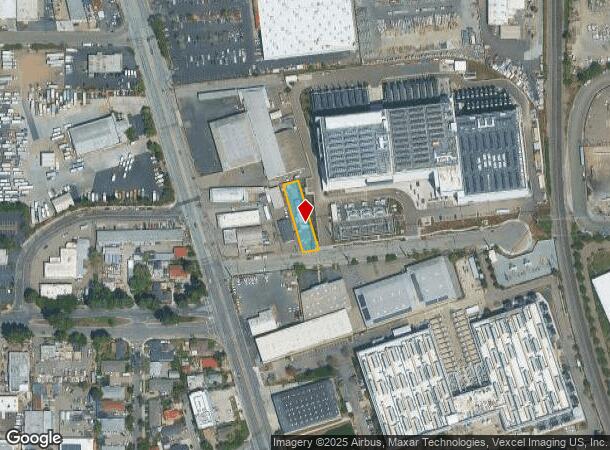
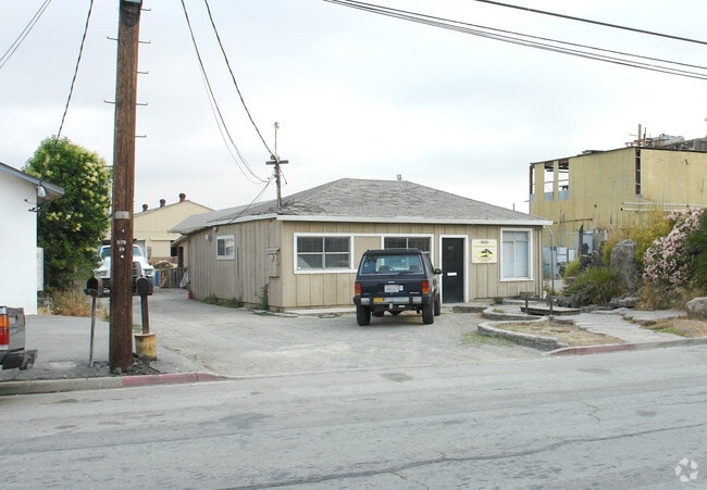
This Property Is For Sale
NEARBY LISTINGS FOR SALE OR LEASE
Property Detail
835 Mathew St
San Jose-Sunnyvale-Santa Clara, CA
Laurelwood Farm Sub
224-40-005
Santa Clara
Slaughterhousestockyard
California
X
1
06085C0227H
0.25 AC
2024
Central Santa Clara
2025
South Bay/San Jose
505202
DEMOGRAPHICS near 835 Mathew St
1 Mile
3 Mile
5 Mile
2024 Total Population
14,164
162,955
586,873
2029 Population
13,866
157,821
568,027
Pop Growth 2024-2029
(2.10%)
(3.15%)
(3.21%)
Average Age
37
38
38
2024 Total Households
5,357
62,736
216,767
HH Growth 2024-2029
(2.17%)
(3.36%)
(3.34%)
Median Household Inc
$105,953
$153,553
$141,880
Avg Household Size
2.50
2.50
2.60
2024 Avg HH Vehicles
2.00
2.00
2.00
Median Home Value
$1,101,856
$1,112,123
$1,087,400
Median Year Built
1974
1976
1977
Nearby Places
- Restaurants
- Banks
- Shops
- Fitness
- Groceries
PUBLIC TRANSPORTATION
COMMUTER RAIL
Santa Clara (Caltrain - Caltrain (Caltrain))
DRIVE
WALK
Distance
Santa Clara (Caltrain - Caltrain (Caltrain))
4 min
1.3 mi
DRIVE
WALK
Distance
4 min
1.3 mi
AIRPORT
Norman Y Mineta San Jose International
DRIVE
WALK
Distance
Norman Y Mineta San Jose International
4 min
1.3 mi
San Francisco International
DRIVE
WALK
Distance
San Francisco International
42 min
32.7 mi
Metro Oakland International
DRIVE
WALK
Distance
Metro Oakland International
47 min
35.1 mi
Freight Ports
Port of Redwood City
DRIVE
WALK
Distance
Port of Redwood City
27 min
19.5 mi
Nearby Properties
Address
Land Use
TOTAL SIZE
Lot Size
Zoning
Address
Land Use
TOTAL SIZE
Lot Size
Zoning
553,793 SF
38.06 AC
ML
Address
Land Use
TOTAL SIZE
Lot Size
Zoning
0.06 AC
PD
Address
Land Use
TOTAL SIZE
Lot Size
Zoning
238,239 SF
24.67 AC
PD
Address
Land Use
TOTAL SIZE
Lot Size
Zoning
576,892 SF
8.28 AC
APD
Address
Land Use
TOTAL SIZE
Lot Size
Zoning
111,585 SF
6.69 AC
ML
Address
Land Use
TOTAL SIZE
Lot Size
Zoning
360,000 SF
18.81 AC
MH
Address
Land Use
TOTAL SIZE
Lot Size
Zoning
181,562 SF
16.51 AC
ML
Address
Land Use
TOTAL SIZE
Lot Size
Zoning
818,051 SF
13.81 AC
CP
Address
Land Use
TOTAL SIZE
Lot Size
Zoning
9.11 AC
ML
Address
Land Use
TOTAL SIZE
Lot Size
Zoning
194,790 SF
5.30 AC
APDCI
Address
Land Use
TOTAL SIZE
Lot Size
Zoning
2.99 AC
MH
Address
Land Use
TOTAL SIZE
Lot Size
Zoning
180,846 SF
12.19 AC
ML
Address
Land Use
TOTAL SIZE
Lot Size
Zoning
242,320 SF
8.01 AC
TEC
Address
Land Use
TOTAL SIZE
Lot Size
Zoning
107.73 AC
CT
Address
Land Use
TOTAL SIZE
Lot Size
Zoning
208,562 SF
9.10 AC
CP
Address
Land Use
TOTAL SIZE
Lot Size
Zoning
22.40 AC
PD
Address
Land Use
TOTAL SIZE
Lot Size
Zoning
22.40 AC
PD
Address
Land Use
TOTAL SIZE
Lot Size
Zoning
309,559 SF
5.69 AC
ML
Address
Land Use
TOTAL SIZE
Lot Size
Zoning
281,574 SF
32.09 AC
IP
Address
Land Use
TOTAL SIZE
Lot Size
Zoning
8.22 AC
PD
Address
Land Use
TOTAL SIZE
Lot Size
Zoning
50,774 SF
3.84 AC
MP
Address
Land Use
TOTAL SIZE
Lot Size
Zoning
320,000 SF
15.18 AC
APD
Address
Land Use
TOTAL SIZE
Lot Size
Zoning
897,944 SF
7.40 AC
PD
Address
Land Use
TOTAL SIZE
Lot Size
Zoning
104,960 SF
10.19 AC
IP
Address
Land Use
TOTAL SIZE
Lot Size
Zoning
500,000 SF
41.05 AC
MH
Address
Land Use
TOTAL SIZE
Lot Size
Zoning
605,915 SF
5.36 AC
APD
Address
Land Use
TOTAL SIZE
Lot Size
Zoning
1,016,763 SF
7.63 AC
CC
Address
Land Use
TOTAL SIZE
Lot Size
Zoning
130,306 SF
8.75 AC
ML
Address
Land Use
TOTAL SIZE
Lot Size
Zoning
2.99 AC
MH
The World's #1 Commercial Real Estate Marketplace
Connect with us
© 2025 CoStar Group
The information above has been obtained from sources believed reliable. While we do not doubt its accuracy we have not verified it and make no guarantee, warranty or representation about it. It is your responsibility to independently confirm its accuracy and completeness. Any projections, opinions, assumptions, or estimates used are for example only and do not represent the current or future performance of the property. The value of this transaction to you depends on tax and other factors which should be evaluated by your tax, financial, and legal advisors. You and your advisors should conduct a careful, independent investigation of the property to determine to your satisfaction the suitability of the property for your needs.