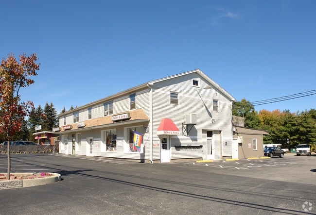
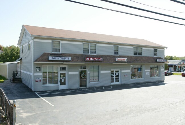
Property Record
835 New Harwinton Rd, Torrington, CT 06790

Property Detail
835 New Harwinton Rd
Torrington, CT
Nw Hills
TORR-000140-000011-000014
Connecticut
Commercialofficeresidentialmixeduse
14
LB
0.74 AC
2025
Torrington
2025
Hartford
310602
NEARBY LISTINGS FOR SALE OR LEASE
DEMOGRAPHICS near 835 New Harwinton Rd
1 mile
3 mile
5 mile
2025 Total Population
5,651
32,098
41,614
2030 Population
5,653
32,105
41,682
Pop Growth 2025-2030
+ 0.04%
+ 0.02%
+ 0.16%
Average Age
45
43
43
2025 Total Households
2,459
14,105
17,823
HH Growth 2025-2030
+ 0.12%
+ 0.06%
+ 0.20%
Median Household Inc
$80,732
$69,057
$76,182
Avg Household Size
2.30
2.20
2.20
2025 Avg HH Vehicles
2.00
2.00
2.00
Median Home Value
$223,420
$213,495
$239,229
Median Year Built
1967
1957
1961
Nearby Places
Map Layers
Map Styles
 Street
 Aerial
Layers
 Traffic
 Biking
Places
Listings with unknown addresses are not visible on the map
- Restaurants
- Banks
- Shops
- Fitness
- Groceries
PUBLIC TRANSPORTATION
AIRPORT
Bradley International
Drive
Walk
Distance
Bradley International
57 min
33.0 mi
Freight Ports
Port of New Haven
Drive
Walk
Distance
Port of New Haven
65 min
46.1 mi
SALE & LEASE HISTORY
LISTING DATE
SALE/LEASE

May 01, 2024
For Lease
Feb 08, 2024
For Lease
Nearby Properties
Address
Land Use
TOTAL SIZE
Lot Size
Zoning
Address
Land Use
TOTAL SIZE
Lot Size
Zoning
119.90 AC
R6
Address
Land Use
TOTAL SIZE
Lot Size
Zoning
171,271 SF
26 AC
R-WP
Address
Land Use
TOTAL SIZE
Lot Size
Zoning
169,551 SF
3.49 AC
I
Address
Land Use
TOTAL SIZE
Lot Size
Zoning
86,780 SF
4.78 AC
R6
Address
Land Use
TOTAL SIZE
Lot Size
Zoning
10.80 AC
R10S
Address
Land Use
TOTAL SIZE
Lot Size
Zoning
85,628 SF
4.25 AC
R6
Address
Land Use
TOTAL SIZE
Lot Size
Zoning
142,840 SF
13.80 AC
R6
Address
Land Use
TOTAL SIZE
Lot Size
Zoning
111,459 SF
16.72 AC
R15
Address
Land Use
TOTAL SIZE
Lot Size
Zoning
128,711 SF
18.50 AC
LB
Address
Land Use
TOTAL SIZE
Lot Size
Zoning
20,365 SF
18.92 AC
R15S
Address
Land Use
TOTAL SIZE
Lot Size
Zoning
137,045 SF
14.49 AC
LB
Address
Land Use
TOTAL SIZE
Lot Size
Zoning
13,576 SF
12.80 AC
R10
Address
Land Use
TOTAL SIZE
Lot Size
Zoning
15.03 AC
DD
Address
Land Use
TOTAL SIZE
Lot Size
Zoning
42,676 SF
3.19 AC
R6
Address
Land Use
TOTAL SIZE
Lot Size
Zoning
95,978 SF
CIR
Address
Land Use
TOTAL SIZE
Lot Size
Zoning
7.71 AC
LB
Address
Land Use
TOTAL SIZE
Lot Size
Zoning
39,111 SF
0.63 AC
DD-R
Address
Land Use
TOTAL SIZE
Lot Size
Zoning
396.22 AC
R-1
Address
Land Use
TOTAL SIZE
Lot Size
Zoning
68,013 SF
9.83 AC
R10S
Address
Land Use
TOTAL SIZE
Lot Size
Zoning
124,360 SF
4.30 AC
DD
Address
Land Use
TOTAL SIZE
Lot Size
Zoning
56,699 SF
11.41 AC
LB
Address
Land Use
TOTAL SIZE
Lot Size
Zoning
68,192 SF
1.76 AC
DD
Address
Land Use
TOTAL SIZE
Lot Size
Zoning
63,735 SF
3.32 AC
CIR
Address
Land Use
TOTAL SIZE
Lot Size
Zoning
25,393 SF
12.60 AC
R10S
Address
Land Use
TOTAL SIZE
Lot Size
Zoning
131,925 SF
12.51 AC
DD
Address
Land Use
TOTAL SIZE
Lot Size
Zoning
93,608 SF
25.40 AC
B
Address
Land Use
TOTAL SIZE
Lot Size
Zoning
15.80 AC
R6
Address
Land Use
TOTAL SIZE
Lot Size
Zoning
24,768 SF
1.67 AC
DD
Address
Land Use
TOTAL SIZE
Lot Size
Zoning
30.48 AC
IP
Address
Land Use
TOTAL SIZE
Lot Size
Zoning
5.41 AC
IP
The World's #1 Commercial Real Estate Marketplace
Connect with us
© 2026 CoStar Group
The information above has been obtained from sources believed reliable. While we do not doubt its accuracy we have not verified it and make no guarantee, warranty or representation about it. It is your responsibility to independently confirm its accuracy and completeness. Any projections, opinions, assumptions, or estimates used are for example only and do not represent the current or future performance of the property. The value of this transaction to you depends on tax and other factors which should be evaluated by your tax, financial, and legal advisors. You and your advisors should conduct a careful, independent investigation of the property to determine to your satisfaction the suitability of the property for your needs.