Property Record
8351 Bryant Dr, Silsbee, TX 77656

Property Detail
8351 Bryant Dr
000003-019172
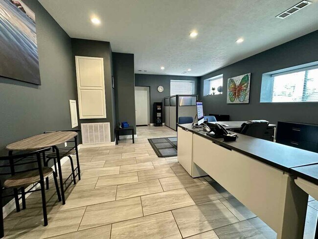
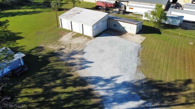
A0003 BANKSTON S P ACRES 2.03 SHOP/STORAGE/OFFICE SHOP/STORAGE/OFFICE
Commercialnec
Hardin
B and X Area of moderate flood hazard, usually the area between the limits of the 100-year and 500-year floods.
Texas
2025
2.03 AC
2025
Hardin County
030900
Beaumont/Port Arthur
4,160 SF
Beaumont-Port Arthur, TX
NEARBY LISTINGS FOR SALE OR LEASE
DEMOGRAPHICS near 8351 Bryant Dr
1 mile
3 mile
5 mile
2025 Total Population
1,770
11,006
16,295
2030 Population
1,832
11,403
16,857
Pop Growth 2025-2030
+ 3.50%
+ 3.61%
+ 3.45%
Average Age
41
41
41
2025 Total Households
699
4,254
6,400
HH Growth 2025-2030
+ 3.58%
+ 3.64%
+ 3.47%
Median Household Inc
$59,654
$62,696
$60,670
Avg Household Size
2.50
2.50
2.50
2025 Avg HH Vehicles
2.00
2.00
2.00
Median Home Value
$90,098
$112,481
$129,538
Median Year Built
1977
1978
1982
Nearby Places
Map Layers
Map Styles
 Street
 Aerial
Transit
 Traffic
 Biking
Places
Listings with unknown addresses are not visible on the map
- Restaurants
- Banks
- Shops
- Fitness
- Groceries
Nearby Properties
Address
Land Use
TOTAL SIZE
Lot Size
Zoning
Address
Land Use
TOTAL SIZE
Lot Size
Zoning
56,042 SF
5.85 AC
Address
Land Use
TOTAL SIZE
Lot Size
Zoning
24,828 SF
3.56 AC
Address
Land Use
TOTAL SIZE
Lot Size
Zoning
22,675 SF
5 AC
Address
Land Use
TOTAL SIZE
Lot Size
Zoning
15,456 SF
3.71 AC
Address
Land Use
TOTAL SIZE
Lot Size
Zoning
2,060 SF
14 AC
Address
Land Use
TOTAL SIZE
Lot Size
Zoning
16,488 SF
1.71 AC
Address
Land Use
TOTAL SIZE
Lot Size
Zoning
231,990 SF
2.72 AC
Address
Land Use
TOTAL SIZE
Lot Size
Zoning
9,226 SF
1.11 AC
Address
Land Use
TOTAL SIZE
Lot Size
Zoning
10,638 SF
0.95 AC
Address
Land Use
TOTAL SIZE
Lot Size
Zoning
20,005 SF
6.07 AC
Address
Land Use
TOTAL SIZE
Lot Size
Zoning
17,449 SF
1.33 AC
Address
Land Use
TOTAL SIZE
Lot Size
Zoning
61,112 SF
5.82 AC
Address
Land Use
TOTAL SIZE
Lot Size
Zoning
43,188 SF
3.28 AC
Address
Land Use
TOTAL SIZE
Lot Size
Zoning
7,500 SF
1 AC
Address
Land Use
TOTAL SIZE
Lot Size
Zoning
15,976 SF
5 AC
Address
Land Use
TOTAL SIZE
Lot Size
Zoning
24,904 SF
3.58 AC
Address
Land Use
TOTAL SIZE
Lot Size
Zoning
20,000 SF
0.92 AC
Address
Land Use
TOTAL SIZE
Lot Size
Zoning
14,241 SF
8.99 AC
Address
Land Use
TOTAL SIZE
Lot Size
Zoning
7,566 SF
9.25 AC
Address
Land Use
TOTAL SIZE
Lot Size
Zoning
57,439 SF
7.53 AC
Address
Land Use
TOTAL SIZE
Lot Size
Zoning
24,959 SF
5 AC
Address
Land Use
TOTAL SIZE
Lot Size
Zoning
14,856 SF
0.62 AC
Address
Land Use
TOTAL SIZE
Lot Size
Zoning
7,204 SF
0.70 AC
Address
Land Use
TOTAL SIZE
Lot Size
Zoning
9,210 SF
1.19 AC
Address
Land Use
TOTAL SIZE
Lot Size
Zoning
9,944 SF
0.74 AC
Address
Land Use
TOTAL SIZE
Lot Size
Zoning
20,656 SF
1.73 AC
Address
Land Use
TOTAL SIZE
Lot Size
Zoning
4,016 SF
2.72 AC
Address
Land Use
TOTAL SIZE
Lot Size
Zoning
4,320 SF
0.36 AC
Address
Land Use
TOTAL SIZE
Lot Size
Zoning
10,304 SF
12.41 AC
Address
Land Use
TOTAL SIZE
Lot Size
Zoning
9,104 SF
4 AC
The World's #1 Commercial Real Estate Marketplace
Connect with us
© 2026 CoStar Group
The information above has been obtained from sources believed reliable. While we do not doubt its accuracy we have not verified it and make no guarantee, warranty or representation about it. It is your responsibility to independently confirm its accuracy and completeness. Any projections, opinions, assumptions, or estimates used are for example only and do not represent the current or future performance of the property. The value of this transaction to you depends on tax and other factors which should be evaluated by your tax, financial, and legal advisors. You and your advisors should conduct a careful, independent investigation of the property to determine to your satisfaction the suitability of the property for your needs.