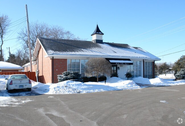
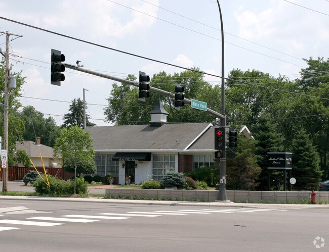
Property Record
8353 Excelsior Blvd, Hopkins, MN 55343
NEARBY LISTINGS FOR SALE OR LEASE
Property Detail
8353 Excelsior Blvd
Minneapolis-St. Paul-Bloomington, MN-WI
Auditors Subd. No. 239
19-117-21-41-0052
LOT 077 B AUDITORS SUBD. NO. 239 ALL THAT PART OF LOT 77, AUDITORS SUBDIVISION NO 239, HENNEPIN COUNTY, MINNESOTA, DESCRIBED AS FOLLOWS: COMENCING AT A POINT IN THE CENTER- T IRREGULAR
Commercialnec
Hennepin
X
Minnesota
27053C0342F
77
2024
0.38 AC
2024
Southdale
023402
Minneapolis/St Paul
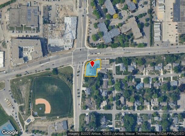
DEMOGRAPHICS near 8353 Excelsior Blvd
1 Mile
3 Mile
5 Mile
2024 Total Population
10,307
102,005
249,223
2029 Population
10,107
100,513
245,840
Pop Growth 2024-2029
(1.94%)
(1.46%)
(1.36%)
Average Age
37
41
41
2024 Total Households
4,619
45,970
113,252
HH Growth 2024-2029
(2.04%)
(1.52%)
(1.36%)
Median Household Inc
$72,142
$91,006
$98,859
Avg Household Size
2.10
2.10
2.10
2024 Avg HH Vehicles
1.00
2.00
2.00
Median Home Value
$359,147
$393,257
$434,536
Median Year Built
1966
1969
1967
Nearby Places
Map Layers
Map Styles
 Street
 Aerial
- Restaurants
- Banks
- Shops
- Fitness
- Groceries
PUBLIC TRANSPORTATION
COMMUTER RAIL
Target Field Station (Northstar Corridor - Northstar Commuter Rail)
DRIVE
WALK
Distance
Target Field Station (Northstar Corridor - Northstar Commuter Rail)
15 min
8.7 mi
AIRPORT
Minneapolis-St Paul International/Wold-Chamberlain
DRIVE
WALK
Distance
Minneapolis-St Paul International/Wold-Chamberlain
23 min
14.7 mi
SALE & LEASE HISTORY
LISTING DATE
SALE/LEASE

Sep 24, 2016
For Sale
Nearby Properties
Address
Land Use
TOTAL SIZE
Lot Size
Zoning
Address
Land Use
TOTAL SIZE
Lot Size
Zoning
7.68 AC
Address
Land Use
TOTAL SIZE
Lot Size
Zoning
4.89 AC
Address
Land Use
TOTAL SIZE
Lot Size
Zoning
6.83 AC
Address
Land Use
TOTAL SIZE
Lot Size
Zoning
19,726 SF
2.08 AC
PCD1
Address
Land Use
TOTAL SIZE
Lot Size
Zoning
1.50 AC
Address
Land Use
TOTAL SIZE
Lot Size
Zoning
0.90 AC
Address
Land Use
TOTAL SIZE
Lot Size
Zoning
Address
Land Use
TOTAL SIZE
Lot Size
Zoning
3.07 AC
Address
Land Use
TOTAL SIZE
Lot Size
Zoning
4,497,396 SF
11.05 AC
Address
Land Use
TOTAL SIZE
Lot Size
Zoning
4.84 AC
Address
Land Use
TOTAL SIZE
Lot Size
Zoning
138,997 SF
14.03 AC
OFC
Address
Land Use
TOTAL SIZE
Lot Size
Zoning
4.55 AC
Address
Land Use
TOTAL SIZE
Lot Size
Zoning
390,060 SF
3.11 AC
Address
Land Use
TOTAL SIZE
Lot Size
Zoning
406,842 SF
1.59 AC
Address
Land Use
TOTAL SIZE
Lot Size
Zoning
1.74 AC
Address
Land Use
TOTAL SIZE
Lot Size
Zoning
3.15 AC
Address
Land Use
TOTAL SIZE
Lot Size
Zoning
19.75 AC
Address
Land Use
TOTAL SIZE
Lot Size
Zoning
233,320 SF
17.37 AC
PUD
Address
Land Use
TOTAL SIZE
Lot Size
Zoning
93,982 SF
9.33 AC
OFC
Address
Land Use
TOTAL SIZE
Lot Size
Zoning
224,581 SF
13.72 AC
PUD
Address
Land Use
TOTAL SIZE
Lot Size
Zoning
398,595 SF
1.91 AC
Address
Land Use
TOTAL SIZE
Lot Size
Zoning
288,096 SF
10.19 AC
Address
Land Use
TOTAL SIZE
Lot Size
Zoning
524,556 SF
4.56 AC
Address
Land Use
TOTAL SIZE
Lot Size
Zoning
38.20 AC
Address
Land Use
TOTAL SIZE
Lot Size
Zoning
379,488 SF
2.68 AC
Address
Land Use
TOTAL SIZE
Lot Size
Zoning
Address
Land Use
TOTAL SIZE
Lot Size
Zoning
127,084 SF
17.21 AC
Address
Land Use
TOTAL SIZE
Lot Size
Zoning
244,941 SF
5.24 AC
Address
Land Use
TOTAL SIZE
Lot Size
Zoning
13.80 AC
Address
Land Use
TOTAL SIZE
Lot Size
Zoning
424,327 SF
2.16 AC
The World's #1 Commercial Real Estate Marketplace
Connect with us
© 2025 CoStar Group
The information above has been obtained from sources believed reliable. While we do not doubt its accuracy we have not verified it and make no guarantee, warranty or representation about it. It is your responsibility to independently confirm its accuracy and completeness. Any projections, opinions, assumptions, or estimates used are for example only and do not represent the current or future performance of the property. The value of this transaction to you depends on tax and other factors which should be evaluated by your tax, financial, and legal advisors. You and your advisors should conduct a careful, independent investigation of the property to determine to your satisfaction the suitability of the property for your needs.