Property Record
8357 Main St, Pinehurst, NC 28374


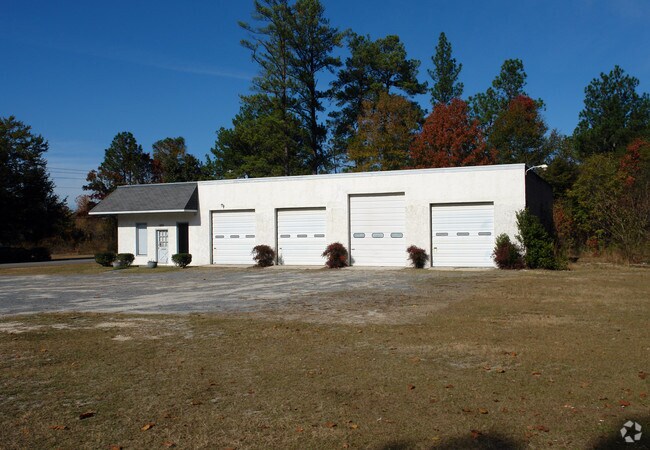
Property Detail
8357 Main St
8553-18-40-9116
GAINES WOODS TAYLORTOWN MUNI MAIN
Autorepair
MOORE
CM
North Carolina
B and X Area of moderate flood hazard, usually the area between the limits of the 100-year and 500-year floods.
0.73 AC
2025
North Carolina Southeast Area
2025
Other Market Areas
950601
Pinehurst-Southern Pines, NC
2,592 SF
NEARBY LISTINGS FOR SALE OR LEASE
-
-
View all Pinehurst listings for sale on LoopNet.com
DEMOGRAPHICS near 8357 Main St
1 mile
3 mile
5 mile
2024 Total Population
2,209
19,512
34,352
2029 Population
2,352
20,755
36,684
Pop Growth 2024-2029
+ 6.47%
+ 6.37%
+ 6.79%
Average Age
51
49
48
2024 Total Households
997
8,700
15,334
HH Growth 2024-2029
+ 6.82%
+ 6.60%
+ 7.02%
Median Household Inc
$81,944
$96,976
$90,953
Avg Household Size
2.20
2.20
2.20
2024 Avg HH Vehicles
2.00
2.00
2.00
Median Home Value
$532,573
$487,541
$470,324
Median Year Built
1993
1994
1995
Nearby Places
Map Layers
Map Styles
 Street
 Aerial
Transit
 Traffic
 Biking
Places
Listings with unknown addresses are not visible on the map
- Restaurants
- Banks
- Shops
- Fitness
- Groceries
PUBLIC TRANSPORTATION
COMMUTER RAIL
Southern Pines Amtrak Station (Silver Star - Amtrak)
Drive
Walk
Distance
Southern Pines Amtrak Station (Silver Star - Amtrak)
13 min
7.1 mi
Freight Ports
Port of Wilmington
Drive
Walk
Distance
Port of Wilmington
176 min
138.7 mi
Nearby Properties
Address
Land Use
TOTAL SIZE
Lot Size
Zoning
Address
Land Use
TOTAL SIZE
Lot Size
Zoning
3,953 SF
86.18 AC
MULTI
Address
Land Use
TOTAL SIZE
Lot Size
Zoning
29,476 SF
22.76 AC
H
Address
Land Use
TOTAL SIZE
Lot Size
Zoning
7,161 SF
0.87 AC
RD
Address
Land Use
TOTAL SIZE
Lot Size
Zoning
132,600 SF
86.18 AC
Address
Land Use
TOTAL SIZE
Lot Size
Zoning
17,091 SF
12.65 AC
R10
Address
Land Use
TOTAL SIZE
Lot Size
Zoning
96,496 SF
35 AC
MULTI
Address
Land Use
TOTAL SIZE
Lot Size
Zoning
11.80 AC
Address
Land Use
TOTAL SIZE
Lot Size
Zoning
190.53 AC
Address
Land Use
TOTAL SIZE
Lot Size
Zoning
70,747 SF
12 AC
RA20
Address
Land Use
TOTAL SIZE
Lot Size
Zoning
155.66 AC
RD
Address
Land Use
TOTAL SIZE
Lot Size
Zoning
7.45 AC
Address
Land Use
TOTAL SIZE
Lot Size
Zoning
26,856 SF
1.52 AC
R10
Address
Land Use
TOTAL SIZE
Lot Size
Zoning
9,417 SF
4.19 AC
OP
Address
Land Use
TOTAL SIZE
Lot Size
Zoning
15,422 SF
35.21 AC
R20
Address
Land Use
TOTAL SIZE
Lot Size
Zoning
4,000 SF
238.22 AC
PDD
Address
Land Use
TOTAL SIZE
Lot Size
Zoning
33,960 SF
18 AC
NC
Address
Land Use
TOTAL SIZE
Lot Size
Zoning
0.87 AC
Address
Land Use
TOTAL SIZE
Lot Size
Zoning
25,651 SF
4.34 AC
CM
Address
Land Use
TOTAL SIZE
Lot Size
Zoning
20,709 SF
3.60 AC
H
Address
Land Use
TOTAL SIZE
Lot Size
Zoning
33,886 SF
9.68 AC
R10
Address
Land Use
TOTAL SIZE
Lot Size
Zoning
0.87 AC
Address
Land Use
TOTAL SIZE
Lot Size
Zoning
47,273 SF
11.25 AC
NC
Address
Land Use
TOTAL SIZE
Lot Size
Zoning
7.43 AC
Address
Land Use
TOTAL SIZE
Lot Size
Zoning
10,435 SF
11.26 AC
R20
Address
Land Use
TOTAL SIZE
Lot Size
Zoning
5,090 SF
99.55 AC
RD
Address
Land Use
TOTAL SIZE
Lot Size
Zoning
36 SF
181.27 AC
RD
Address
Land Use
TOTAL SIZE
Lot Size
Zoning
5,700 SF
205.35 AC
RS2CD
Address
Land Use
TOTAL SIZE
Lot Size
Zoning
480 SF
73.70 AC
PC
Address
Land Use
TOTAL SIZE
Lot Size
Zoning
18,895 SF
86.18 AC
Address
Land Use
TOTAL SIZE
Lot Size
Zoning
10.94 AC
The World's #1 Commercial Real Estate Marketplace
Connect with us
© 2026 CoStar Group
The information above has been obtained from sources believed reliable. While we do not doubt its accuracy we have not verified it and make no guarantee, warranty or representation about it. It is your responsibility to independently confirm its accuracy and completeness. Any projections, opinions, assumptions, or estimates used are for example only and do not represent the current or future performance of the property. The value of this transaction to you depends on tax and other factors which should be evaluated by your tax, financial, and legal advisors. You and your advisors should conduct a careful, independent investigation of the property to determine to your satisfaction the suitability of the property for your needs.