Property Record
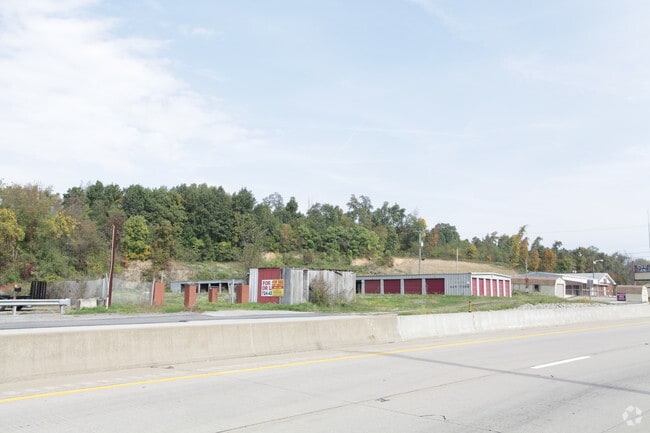
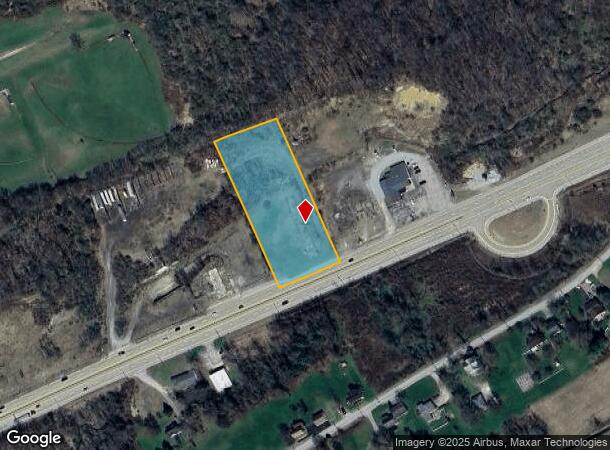
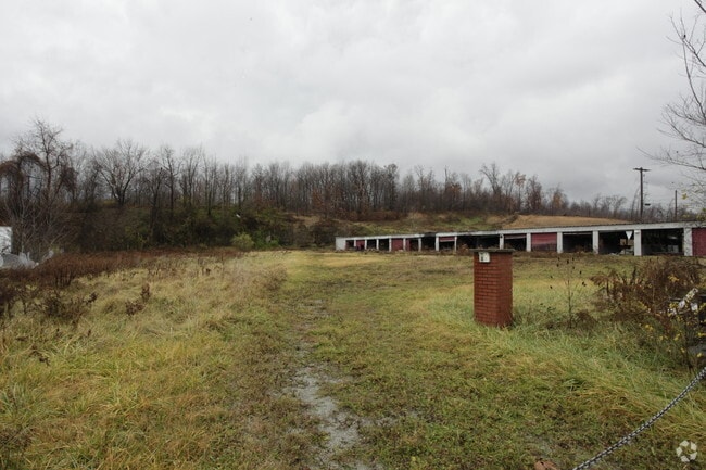
8358 United States Hwy, New Alexandria, PA 15670
This Property Is For Sale
NEARBY LISTINGS FOR SALE OR LEASE
-
-
View all New Alexandria listings for sale on LoopNet.com
Property Detail
8358 United States Hwy
22-01-11-0-022
COM LOT, BLDG (FIRE DAMAGED)
Commercialacreage
Westmoreland
X
Pennsylvania
42063C0495F
2.19 AC
2025
Westmoreland County
2025
Pittsburgh
807901
Pittsburgh, PA
DEMOGRAPHICS near 8358 United States Hwy
1 Mile
3 Mile
5 Mile
2024 Total Population
717
2,184
6,482
2029 Population
693
2,114
6,288
Pop Growth 2024-2029
(3.35%)
(3.21%)
(2.99%)
Average Age
47
47
46
2024 Total Households
321
955
2,745
HH Growth 2024-2029
(3.43%)
(3.35%)
(3.10%)
Median Household Inc
$68,942
$66,000
$70,390
Avg Household Size
2.20
2.20
2.30
2024 Avg HH Vehicles
2.00
2.00
2.00
Median Home Value
$173,529
$182,194
$188,147
Median Year Built
1963
1966
1968
Nearby Places
- Restaurants
- Banks
- Shops
- Fitness
- Groceries
PUBLIC TRANSPORTATION
COMMUTER RAIL
Latrobe Amtrak (Pennsylvanian - Amtrak)
DRIVE
WALK
Distance
Latrobe Amtrak (Pennsylvanian - Amtrak)
13 min
7.7 mi
AIRPORT
Arnold Palmer Regional
DRIVE
WALK
Distance
Arnold Palmer Regional
20 min
11.5 mi
Freight Ports
Port of Baltimore
DRIVE
WALK
Distance
Port of Baltimore
273 min
207.3 mi
Nearby Properties
Address
Land Use
TOTAL SIZE
Lot Size
Zoning
Address
Land Use
TOTAL SIZE
Lot Size
Zoning
Address
Land Use
TOTAL SIZE
Lot Size
Zoning
Address
Land Use
TOTAL SIZE
Lot Size
Zoning
Address
Land Use
TOTAL SIZE
Lot Size
Zoning
Address
Land Use
TOTAL SIZE
Lot Size
Zoning
856.70 AC
Address
Land Use
TOTAL SIZE
Lot Size
Zoning
Address
Land Use
TOTAL SIZE
Lot Size
Zoning
17,262 SF
6 AC
Address
Land Use
TOTAL SIZE
Lot Size
Zoning
4,602 SF
1 AC
Address
Land Use
TOTAL SIZE
Lot Size
Zoning
1,008 SF
5.28 AC
Address
Land Use
TOTAL SIZE
Lot Size
Zoning
110.07 AC
Address
Land Use
TOTAL SIZE
Lot Size
Zoning
Address
Land Use
TOTAL SIZE
Lot Size
Zoning
279 AC
Address
Land Use
TOTAL SIZE
Lot Size
Zoning
Address
Land Use
TOTAL SIZE
Lot Size
Zoning
2,744 SF
2.01 AC
Address
Land Use
TOTAL SIZE
Lot Size
Zoning
4,234 SF
1.20 AC
Address
Land Use
TOTAL SIZE
Lot Size
Zoning
13,500 SF
13.90 AC
Address
Land Use
TOTAL SIZE
Lot Size
Zoning
4,240 SF
3.07 AC
Address
Land Use
TOTAL SIZE
Lot Size
Zoning
Address
Land Use
TOTAL SIZE
Lot Size
Zoning
Address
Land Use
TOTAL SIZE
Lot Size
Zoning
5,914 SF
67.90 AC
Address
Land Use
TOTAL SIZE
Lot Size
Zoning
2,880 SF
0.28 AC
Address
Land Use
TOTAL SIZE
Lot Size
Zoning
4.78 AC
Address
Land Use
TOTAL SIZE
Lot Size
Zoning
67.74 AC
Address
Land Use
TOTAL SIZE
Lot Size
Zoning
Address
Land Use
TOTAL SIZE
Lot Size
Zoning
3,476 SF
15.33 AC
Address
Land Use
TOTAL SIZE
Lot Size
Zoning
58.50 AC
Address
Land Use
TOTAL SIZE
Lot Size
Zoning
Address
Land Use
TOTAL SIZE
Lot Size
Zoning
2,968 SF
108.60 AC
Address
Land Use
TOTAL SIZE
Lot Size
Zoning
3,012 SF
52 AC
Address
Land Use
TOTAL SIZE
Lot Size
Zoning
2,610 SF
216.23 AC
The World's #1 Commercial Real Estate Marketplace
Connect with us
© 2025 CoStar Group
The information above has been obtained from sources believed reliable. While we do not doubt its accuracy we have not verified it and make no guarantee, warranty or representation about it. It is your responsibility to independently confirm its accuracy and completeness. Any projections, opinions, assumptions, or estimates used are for example only and do not represent the current or future performance of the property. The value of this transaction to you depends on tax and other factors which should be evaluated by your tax, financial, and legal advisors. You and your advisors should conduct a careful, independent investigation of the property to determine to your satisfaction the suitability of the property for your needs.