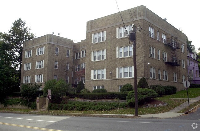
Property Record
836 Bloomfield Ave, Montclair, NJ 07042


Save to a Folder
{{folder.Name}}
{{folder.ListingIds.length}} Properties
{{folder.ListingIds.length}} Property
Create a New Folder
Property Detail
836 Bloomfield Ave
13-00402-0000-00006
130X91 IRR
Apartment
Essex
R4
New Jersey
B and X Area of moderate flood hazard, usually the area between the limits of the 100-year and 500-year floods.
6
2025
0.27 AC
2026
Upper Essex County
016900
Northern New Jersey
17,082 SF
Newark, NJ
NEARBY LISTINGS FOR SALE OR LEASE
DEMOGRAPHICS near 836 Bloomfield Ave
1 mile
3 mile
5 mile
2025 Total Population
19,460
165,809
540,862
2030 Population
20,516
173,617
564,291
Pop Growth 2025-2030
+ 5.43%
+ 4.71%
+ 4.33%
Average Age
42
41
41
2025 Total Households
8,622
62,551
204,041
HH Growth 2025-2030
+ 5.64%
+ 4.90%
+ 4.51%
Median Household Inc
$157,598
$139,448
$99,225
Avg Household Size
2.20
2.50
2.60
2025 Avg HH Vehicles
2.00
2.00
2.00
Median Home Value
$649,661
$640,538
$527,748
Median Year Built
1949
1952
1956
Nearby Places
Map Layers
Map Styles
 Street
 Aerial
Layers
 Traffic
 Biking
Places
Listings with unknown addresses are not visible on the map
- Restaurants
- Banks
- Shops
- Fitness
- Groceries
PUBLIC TRANSPORTATION
COMMUTER RAIL
Watchung Avenue (Montclair-Boonton Line - NJ TRANSIT RAIL)
Drive
Walk
Distance
Watchung Avenue (Montclair-Boonton Line - NJ TRANSIT RAIL)
4 min
1.7 mi
Walnut Street (Montclair-Boonton Line - NJ TRANSIT RAIL)
Drive
Walk
Distance
Walnut Street (Montclair-Boonton Line - NJ TRANSIT RAIL)
4 min
1.8 mi
AIRPORT
Newark Liberty International
Drive
Walk
Distance
Newark Liberty International
21 min
12.4 mi
LaGuardia
Drive
Walk
Distance
LaGuardia
46 min
25.6 mi
John F Kennedy International
Drive
Walk
Distance
John F Kennedy International
54 min
33.7 mi
Freight Ports
Port Newark Container Terminal
Drive
Walk
Distance
Port Newark Container Terminal
23 min
12.2 mi
Nearby Properties
Address
Land Use
TOTAL SIZE
Lot Size
Zoning
Address
Land Use
TOTAL SIZE
Lot Size
Zoning
5 AC
H
Address
Land Use
TOTAL SIZE
Lot Size
Zoning
33.60 AC
P-C
Address
Land Use
TOTAL SIZE
Lot Size
Zoning
Address
Land Use
TOTAL SIZE
Lot Size
Zoning
1,589 SF
0.22 AC
R4
Address
Land Use
TOTAL SIZE
Lot Size
Zoning
12.54 AC
OPRP
Address
Land Use
TOTAL SIZE
Lot Size
Zoning
0.24 AC
R4
Address
Land Use
TOTAL SIZE
Lot Size
Zoning
298,272 SF
31.36 AC
P-6
Address
Land Use
TOTAL SIZE
Lot Size
Zoning
32.34 AC
RA
Address
Land Use
TOTAL SIZE
Lot Size
Zoning
3.26 AC
PR
Address
Land Use
TOTAL SIZE
Lot Size
Zoning
0.17 AC
BCR1
Address
Land Use
TOTAL SIZE
Lot Size
Zoning
25.88 AC
Address
Land Use
TOTAL SIZE
Lot Size
Zoning
1.67 AC
BCR1
Address
Land Use
TOTAL SIZE
Lot Size
Zoning
14.54 AC
R-MF
Address
Land Use
TOTAL SIZE
Lot Size
Zoning
3.20 AC
BSRD
Address
Land Use
TOTAL SIZE
Lot Size
Zoning
224 SF
0.94 AC
BCR1
Address
Land Use
TOTAL SIZE
Lot Size
Zoning
1.50 AC
RA
Address
Land Use
TOTAL SIZE
Lot Size
Zoning
1.95 AC
RA
Address
Land Use
TOTAL SIZE
Lot Size
Zoning
3.64 AC
R-M
Address
Land Use
TOTAL SIZE
Lot Size
Zoning
6.30 AC
B
Address
Land Use
TOTAL SIZE
Lot Size
Zoning
364.34 AC
R-1
Address
Land Use
TOTAL SIZE
Lot Size
Zoning
13.82 AC
O
Address
Land Use
TOTAL SIZE
Lot Size
Zoning
4.08 AC
Address
Land Use
TOTAL SIZE
Lot Size
Zoning
25.80 AC
P
Address
Land Use
TOTAL SIZE
Lot Size
Zoning
17.90 AC
R-G
Address
Land Use
TOTAL SIZE
Lot Size
Zoning
12,808 SF
12.08 AC
R-G
Address
Land Use
TOTAL SIZE
Lot Size
Zoning
103.46 AC
R-40
Address
Land Use
TOTAL SIZE
Lot Size
Zoning
73,436 SF
189.03 AC
R-2
Address
Land Use
TOTAL SIZE
Lot Size
Zoning
1,063 SF
14.08 AC
C-1
Address
Land Use
TOTAL SIZE
Lot Size
Zoning
Address
Land Use
TOTAL SIZE
Lot Size
Zoning
5.06 AC
The World's #1 Commercial Real Estate Marketplace
Connect with us
© 2026 CoStar Group
The information above has been obtained from sources believed reliable. While we do not doubt its accuracy we have not verified it and make no guarantee, warranty or representation about it. It is your responsibility to independently confirm its accuracy and completeness. Any projections, opinions, assumptions, or estimates used are for example only and do not represent the current or future performance of the property. The value of this transaction to you depends on tax and other factors which should be evaluated by your tax, financial, and legal advisors. You and your advisors should conduct a careful, independent investigation of the property to determine to your satisfaction the suitability of the property for your needs.