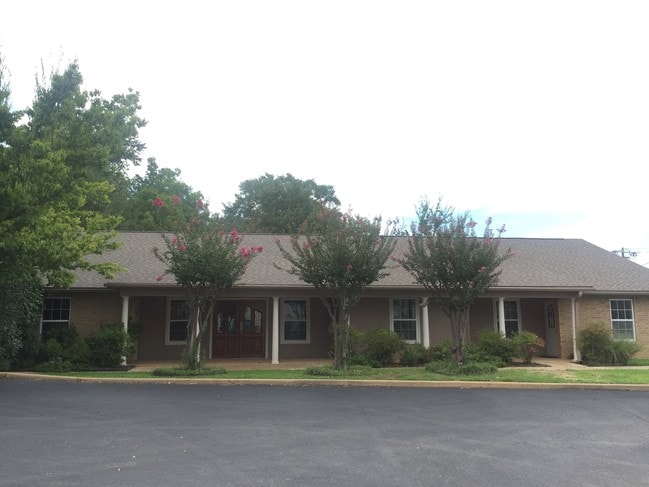
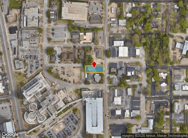
Property Record
837 S Fleishel Ave, Tyler, TX 75701
NEARBY LISTINGS FOR SALE OR LEASE
Property Detail
837 S Fleishel Ave
Tyler, TX
East Texas Hosp Fdn
1-50000-0679-00-004010
EAST TEXAS HOSP FDNBLOCK 679 LOT 4A, 4B
Officebuilding
Smith
X
Texas
48423C0360D
4a,4b
2024
0.34 AC
2025
Tyler & Longview
000900
Other Market Areas
3,308 SF
DEMOGRAPHICS near 837 S Fleishel Ave
1 Mile
3 Mile
5 Mile
2024 Total Population
10,437
64,852
114,444
2029 Population
11,352
70,629
124,518
Pop Growth 2024-2029
+ 8.77%
+ 8.91%
+ 8.80%
Average Age
36
36
37
2024 Total Households
3,635
23,752
44,449
HH Growth 2024-2029
+ 8.25%
+ 8.43%
+ 8.27%
Median Household Inc
$48,499
$49,968
$55,699
Avg Household Size
2.40
2.50
2.40
2024 Avg HH Vehicles
2.00
2.00
2.00
Median Home Value
$168,491
$154,122
$168,465
Median Year Built
1956
1966
1978
Nearby Places
Map Layers
Map Styles
 Street
 Aerial
- Restaurants
- Banks
- Shops
- Fitness
- Groceries
PUBLIC TRANSPORTATION
AIRPORT
Tyler Pounds Regional
DRIVE
WALK
Distance
Tyler Pounds Regional
18 min
9.2 mi
Freight Ports
Port of Shreveport
DRIVE
WALK
Distance
Port of Shreveport
122 min
106.9 mi
SALE & LEASE HISTORY
LISTING DATE
SALE/LEASE

Sep 25, 2016
For Lease
Nov 14, 2022
For Lease
Nearby Properties
Address
Land Use
TOTAL SIZE
Lot Size
Zoning
Address
Land Use
TOTAL SIZE
Lot Size
Zoning
14,000 SF
367.52 AC
M2
Address
Land Use
TOTAL SIZE
Lot Size
Zoning
12.64 AC
Address
Land Use
TOTAL SIZE
Lot Size
Zoning
22,500 SF
214.44 AC
R1A
Address
Land Use
TOTAL SIZE
Lot Size
Zoning
503,620 SF
11.42 AC
Address
Land Use
TOTAL SIZE
Lot Size
Zoning
1.47 AC
RMF
Address
Land Use
TOTAL SIZE
Lot Size
Zoning
9.98 AC
Address
Land Use
TOTAL SIZE
Lot Size
Zoning
18.37 AC
R1A
Address
Land Use
TOTAL SIZE
Lot Size
Zoning
403,396 SF
45.40 AC
C4
Address
Land Use
TOTAL SIZE
Lot Size
Zoning
168,390 SF
7.51 AC
Address
Land Use
TOTAL SIZE
Lot Size
Zoning
Address
Land Use
TOTAL SIZE
Lot Size
Zoning
24.83 AC
Address
Land Use
TOTAL SIZE
Lot Size
Zoning
39.16 AC
C2
Address
Land Use
TOTAL SIZE
Lot Size
Zoning
Address
Land Use
TOTAL SIZE
Lot Size
Zoning
16.53 AC
Address
Land Use
TOTAL SIZE
Lot Size
Zoning
1.78 AC
DBAC
Address
Land Use
TOTAL SIZE
Lot Size
Zoning
Address
Land Use
TOTAL SIZE
Lot Size
Zoning
448,500 SF
2.90 AC
INT
Address
Land Use
TOTAL SIZE
Lot Size
Zoning
238,658 SF
1.97 AC
INT
Address
Land Use
TOTAL SIZE
Lot Size
Zoning
25 AC
INT
Address
Land Use
TOTAL SIZE
Lot Size
Zoning
213,323 SF
1.21 AC
Address
Land Use
TOTAL SIZE
Lot Size
Zoning
38,010 SF
12.07 AC
R1A
Address
Land Use
TOTAL SIZE
Lot Size
Zoning
20,071 SF
7.43 AC
Address
Land Use
TOTAL SIZE
Lot Size
Zoning
66.86 AC
R1A
Address
Land Use
TOTAL SIZE
Lot Size
Zoning
Address
Land Use
TOTAL SIZE
Lot Size
Zoning
37,536 SF
16.81 AC
RMF
Address
Land Use
TOTAL SIZE
Lot Size
Zoning
88,964 SF
11.33 AC
Address
Land Use
TOTAL SIZE
Lot Size
Zoning
111,030 SF
1.02 AC
Address
Land Use
TOTAL SIZE
Lot Size
Zoning
2,676 SF
8.28 AC
RMF
Address
Land Use
TOTAL SIZE
Lot Size
Zoning
207,919 SF
1.90 AC
DBAC
Address
Land Use
TOTAL SIZE
Lot Size
Zoning
83,450 SF
The World's #1 Commercial Real Estate Marketplace
Connect with us
© 2025 CoStar Group
The information above has been obtained from sources believed reliable. While we do not doubt its accuracy we have not verified it and make no guarantee, warranty or representation about it. It is your responsibility to independently confirm its accuracy and completeness. Any projections, opinions, assumptions, or estimates used are for example only and do not represent the current or future performance of the property. The value of this transaction to you depends on tax and other factors which should be evaluated by your tax, financial, and legal advisors. You and your advisors should conduct a careful, independent investigation of the property to determine to your satisfaction the suitability of the property for your needs.