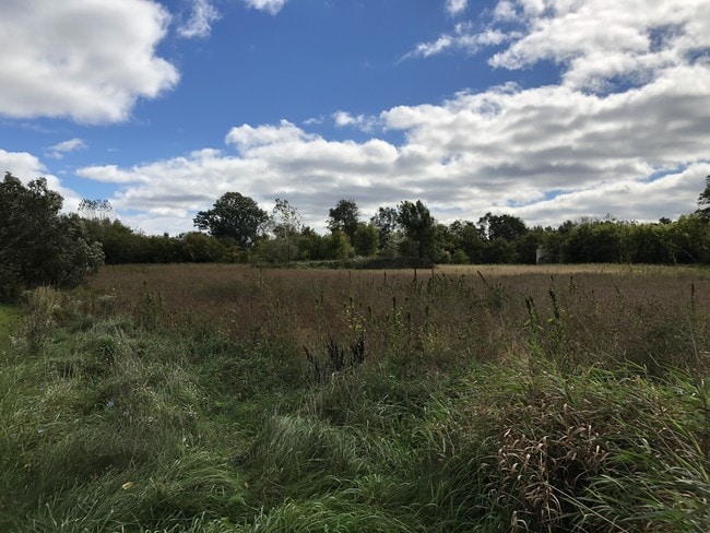
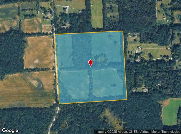
Property Record
8370 Nollar Rd, South Lyon, MI 48178
NEARBY LISTINGS FOR SALE OR LEASE
Property Detail
8370 Nollar Rd
02-09-400-005
OLD SID - B 02-009-042-00 NO 9-11A NW 1/4 OF SE 1/4 SEC 9 T1S R6E 40.0 AC
Agriculturalland
Washtenaw
X
Michigan
26161C0111E
40 AC
2025
Washtenaw E of 23
2025
Detroit
139202
Ann Arbor, MI
DEMOGRAPHICS near 8370 Nollar Rd
1 Mile
3 Mile
5 Mile
2024 Total Population
395
11,680
28,601
2029 Population
388
11,729
28,879
Pop Growth 2024-2029
(1.77%)
+ 0.42%
+ 0.97%
Average Age
42
41
43
2024 Total Households
166
4,675
11,213
HH Growth 2024-2029
(1.81%)
+ 0.36%
+ 0.93%
Median Household Inc
$91,477
$78,691
$90,942
Avg Household Size
2.30
2.40
2.50
2024 Avg HH Vehicles
2.00
2.00
2.00
Median Home Value
$312,903
$278,547
$333,620
Median Year Built
1987
1991
1990
Nearby Places
Map Layers
Map Styles
 Street
 Aerial
- Restaurants
- Banks
- Shops
- Fitness
- Groceries
PUBLIC TRANSPORTATION
AIRPORT
Detroit Metro Wayne County
DRIVE
WALK
Distance
Detroit Metro Wayne County
51 min
37.8 mi
Freight Ports
Port of Toledo
DRIVE
WALK
Distance
Port of Toledo
93 min
70.8 mi
SALE & LEASE HISTORY
LISTING DATE
SALE/LEASE

Nov 07, 2018
For Sale
Nearby Properties
Address
Land Use
TOTAL SIZE
Lot Size
Zoning
Address
Land Use
TOTAL SIZE
Lot Size
Zoning
291,012 SF
70.69 AC
P.U.D
Address
Land Use
TOTAL SIZE
Lot Size
Zoning
291,012 SF
Address
Land Use
TOTAL SIZE
Lot Size
Zoning
9,208 SF
230 AC
RE
Address
Land Use
TOTAL SIZE
Lot Size
Zoning
893 SF
130.95 AC
MHP-MOBIL
Address
Land Use
TOTAL SIZE
Lot Size
Zoning
32,964 SF
11.95 AC
MR-MULTIPL
Address
Land Use
TOTAL SIZE
Lot Size
Zoning
10,839 SF
9.52 AC
MR-MULTIPL
Address
Land Use
TOTAL SIZE
Lot Size
Zoning
101,120 SF
12.30 AC
RM
Address
Land Use
TOTAL SIZE
Lot Size
Zoning
12,000 SF
26.97 AC
GI-GEN IND
Address
Land Use
TOTAL SIZE
Lot Size
Zoning
62,548 SF
4.28 AC
GC-GEN COM
Address
Land Use
TOTAL SIZE
Lot Size
Zoning
41.13 AC
GC-GEN COM
Address
Land Use
TOTAL SIZE
Lot Size
Zoning
65.46 AC
GC-GEN COM
Address
Land Use
TOTAL SIZE
Lot Size
Zoning
17.83 AC
HC
Address
Land Use
TOTAL SIZE
Lot Size
Zoning
50,733 SF
12.51 AC
RTM-RESEAR
Address
Land Use
TOTAL SIZE
Lot Size
Zoning
70.16 AC
PSC-PLANNE
Address
Land Use
TOTAL SIZE
Lot Size
Zoning
29,190 SF
19.97 AC
RTM-RESEAR
Address
Land Use
TOTAL SIZE
Lot Size
Zoning
46,647 SF
7.16 AC
GB
Address
Land Use
TOTAL SIZE
Lot Size
Zoning
49,834 SF
8 AC
RTM-RESEAR
Address
Land Use
TOTAL SIZE
Lot Size
Zoning
35,119 SF
RTM-RESEAR
Address
Land Use
TOTAL SIZE
Lot Size
Zoning
35.74 AC
GC-GEN COM
Address
Land Use
TOTAL SIZE
Lot Size
Zoning
14,162 SF
158.28 AC
AR-AGRICUL
Address
Land Use
TOTAL SIZE
Lot Size
Zoning
47,088 SF
7.72 AC
RM
Address
Land Use
TOTAL SIZE
Lot Size
Zoning
22,676 SF
5.30 AC
GC-GEN COM
Address
Land Use
TOTAL SIZE
Lot Size
Zoning
24,500 SF
12.15 AC
GI
Address
Land Use
TOTAL SIZE
Lot Size
Zoning
12,942 SF
1.52 AC
VC
Address
Land Use
TOTAL SIZE
Lot Size
Zoning
3,800 SF
5.53 AC
GC-GEN COM
Address
Land Use
TOTAL SIZE
Lot Size
Zoning
29,636 SF
3.51 AC
R1
Address
Land Use
TOTAL SIZE
Lot Size
Zoning
16,488 SF
10.02 AC
LI-LTD IND
Address
Land Use
TOTAL SIZE
Lot Size
Zoning
9,600 SF
10.13 AC
LI-LTD IND
Address
Land Use
TOTAL SIZE
Lot Size
Zoning
4,148 SF
2.15 AC
HC
Address
Land Use
TOTAL SIZE
Lot Size
Zoning
18,648 SF
19.67 AC
GI-GEN IND
The World's #1 Commercial Real Estate Marketplace
Connect with us
© 2025 CoStar Group
The information above has been obtained from sources believed reliable. While we do not doubt its accuracy we have not verified it and make no guarantee, warranty or representation about it. It is your responsibility to independently confirm its accuracy and completeness. Any projections, opinions, assumptions, or estimates used are for example only and do not represent the current or future performance of the property. The value of this transaction to you depends on tax and other factors which should be evaluated by your tax, financial, and legal advisors. You and your advisors should conduct a careful, independent investigation of the property to determine to your satisfaction the suitability of the property for your needs.