Property Record
8376 Anthony Wayne Ave, Cincinnati, OH 45216
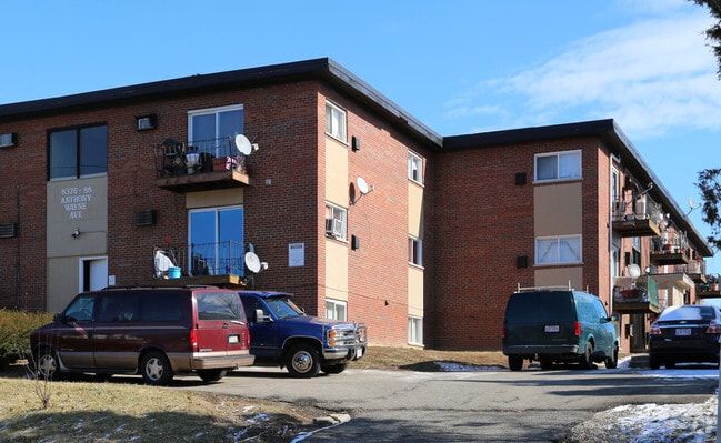
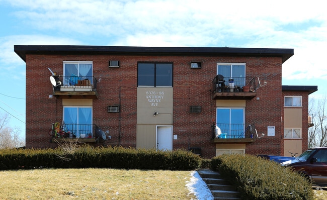

Property Detail
8376 Anthony Wayne Ave
245-0004-0002
SHEEHAN AVE 100 X 262.67 IRR PT LOT 7 J F MILLS- MAPLEWOOD SUB - PARS 2-76CONS
Apartment
Hamilton
RM20
Ohio
B and X Area of moderate flood hazard, usually the area between the limits of the 100-year and 500-year floods.
7
2025
0.59 AC
2025
Hartwell
006000
Cincinnati/Dayton
19,584 SF
Cincinnati, OH-KY-IN
NEARBY LISTINGS FOR SALE OR LEASE
DEMOGRAPHICS near 8376 Anthony Wayne Ave
1 mile
3 mile
5 mile
2025 Total Population
11,558
78,688
232,978
2030 Population
11,652
79,342
234,914
Pop Growth 2025-2030
+ 0.81%
+ 0.83%
+ 0.83%
Average Age
39
41
40
2025 Total Households
4,970
33,714
101,291
HH Growth 2025-2030
+ 0.82%
+ 0.90%
+ 0.83%
Median Household Inc
$58,091
$63,063
$66,060
Avg Household Size
2.30
2.20
2.20
2025 Avg HH Vehicles
2.00
2.00
2.00
Median Home Value
$163,622
$229,005
$236,079
Median Year Built
1948
1954
1955
Nearby Places
Map Layers
Map Styles
 Street
 Aerial
Layers
 Traffic
 Biking
Places
Listings with unknown addresses are not visible on the map
- Restaurants
- Banks
- Shops
- Fitness
- Groceries
PUBLIC TRANSPORTATION
AIRPORT
Cincinnati/Northern Kentucky International
Drive
Walk
Distance
Cincinnati/Northern Kentucky International
25 min
23.5 mi
Freight Ports
Virginia Port Authority - Richmond
Drive
Walk
Distance
Virginia Port Authority - Richmond
1 min
400.3 mi
Nearby Properties
Address
Land Use
TOTAL SIZE
Lot Size
Zoning
Address
Land Use
TOTAL SIZE
Lot Size
Zoning
1,238 SF
14.03 AC
Address
Land Use
TOTAL SIZE
Lot Size
Zoning
29.67 AC
RM20
Address
Land Use
TOTAL SIZE
Lot Size
Zoning
11,639 SF
7.87 AC
R2
Address
Land Use
TOTAL SIZE
Lot Size
Zoning
23.45 AC
Address
Land Use
TOTAL SIZE
Lot Size
Zoning
15.61 AC
Address
Land Use
TOTAL SIZE
Lot Size
Zoning
8,964 SF
11.61 AC
Address
Land Use
TOTAL SIZE
Lot Size
Zoning
330,335 SF
0.80 AC
R3
Address
Land Use
TOTAL SIZE
Lot Size
Zoning
42.41 AC
Address
Land Use
TOTAL SIZE
Lot Size
Zoning
344,923 SF
18.47 AC
RM20
Address
Land Use
TOTAL SIZE
Lot Size
Zoning
13.08 AC
Address
Land Use
TOTAL SIZE
Lot Size
Zoning
Address
Land Use
TOTAL SIZE
Lot Size
Zoning
Address
Land Use
TOTAL SIZE
Lot Size
Zoning
2.22 AC
Address
Land Use
TOTAL SIZE
Lot Size
Zoning
4.64 AC
SF20
Address
Land Use
TOTAL SIZE
Lot Size
Zoning
Address
Land Use
TOTAL SIZE
Lot Size
Zoning
88.15 AC
ML
Address
Land Use
TOTAL SIZE
Lot Size
Zoning
8,720 SF
33.28 AC
R3
Address
Land Use
TOTAL SIZE
Lot Size
Zoning
Address
Land Use
TOTAL SIZE
Lot Size
Zoning
23.41 AC
Address
Land Use
TOTAL SIZE
Lot Size
Zoning
31.98 AC
Address
Land Use
TOTAL SIZE
Lot Size
Zoning
25.26 AC
Address
Land Use
TOTAL SIZE
Lot Size
Zoning
9.74 AC
PD
Address
Land Use
TOTAL SIZE
Lot Size
Zoning
49,338 SF
2.81 AC
PD
Address
Land Use
TOTAL SIZE
Lot Size
Zoning
223,920 SF
9.55 AC
RM20
Address
Land Use
TOTAL SIZE
Lot Size
Zoning
Address
Land Use
TOTAL SIZE
Lot Size
Zoning
19.13 AC
Address
Land Use
TOTAL SIZE
Lot Size
Zoning
117,975 SF
7.26 AC
Address
Land Use
TOTAL SIZE
Lot Size
Zoning
4 AC
CGA
Address
Land Use
TOTAL SIZE
Lot Size
Zoning
Address
Land Use
TOTAL SIZE
Lot Size
Zoning
65.26 AC
R3
The World's #1 Commercial Real Estate Marketplace
Connect with us
© 2026 CoStar Group
The information above has been obtained from sources believed reliable. While we do not doubt its accuracy we have not verified it and make no guarantee, warranty or representation about it. It is your responsibility to independently confirm its accuracy and completeness. Any projections, opinions, assumptions, or estimates used are for example only and do not represent the current or future performance of the property. The value of this transaction to you depends on tax and other factors which should be evaluated by your tax, financial, and legal advisors. You and your advisors should conduct a careful, independent investigation of the property to determine to your satisfaction the suitability of the property for your needs.