Property Record
838 Odum Rd, Gardendale, AL 35071


NEARBY LISTINGS FOR SALE OR LEASE
-
-
View all Gardendale listings for lease on LoopNet.com
Property Detail
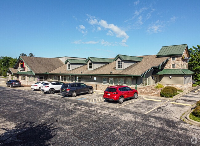
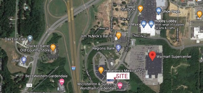
838 Odum Rd
Birmingham-Hoover, AL
Gardendale Exchange Ad Am
14-00-14-2-003-050.001
LOT 2-A RESURVEY OF LOT 2 GARDENDALE EXCHANGES ADDITION TO GARDENDALE PB 209 PG 71 AMENDED MAP PB 210 PG 71
Restaurantbuilding
Jefferson
X
Alabama
01073C0215H
2-a,2
2024
3.30 AC
2024
Fultondale
011707
Birmingham
11,027 SF
DEMOGRAPHICS near 838 Odum Rd
1 Mile
3 Mile
5 Mile
2024 Total Population
2,419
19,485
32,568
2029 Population
2,324
18,808
31,621
Pop Growth 2024-2029
(3.93%)
(3.47%)
(2.91%)
Average Age
40
41
41
2024 Total Households
1,046
7,881
13,230
HH Growth 2024-2029
(3.92%)
(3.59%)
(2.99%)
Median Household Inc
$56,622
$70,731
$68,081
Avg Household Size
2.30
2.40
2.40
2024 Avg HH Vehicles
2.00
2.00
2.00
Median Home Value
$184,421
$183,507
$185,957
Median Year Built
1985
1979
1983
Nearby Places
Map Layers
Map Styles
 Street
 Aerial
- Restaurants
- Banks
- Shops
- Fitness
- Groceries
PUBLIC TRANSPORTATION
AIRPORT
Birmingham-Shuttlesworth International
DRIVE
WALK
Distance
Birmingham-Shuttlesworth International
25 min
17.3 mi
SALE & LEASE HISTORY
LISTING DATE
SALE/LEASE

Nov 13, 2020
For Lease
Nov 13, 2020
For Sale
May 09, 2017
For Lease
Mar 29, 2017
For Sale
Nearby Properties
Address
Land Use
TOTAL SIZE
Lot Size
Zoning
Address
Land Use
TOTAL SIZE
Lot Size
Zoning
176,544 SF
17 AC
C-2
Address
Land Use
TOTAL SIZE
Lot Size
Zoning
81,419 SF
29.70 AC
R4
Address
Land Use
TOTAL SIZE
Lot Size
Zoning
161,736 SF
6.70 AC
C2
Address
Land Use
TOTAL SIZE
Lot Size
Zoning
203,208 SF
27.37 AC
C2
Address
Land Use
TOTAL SIZE
Lot Size
Zoning
196,498 SF
11.71 AC
R-4
Address
Land Use
TOTAL SIZE
Lot Size
Zoning
46,371 SF
15.90 AC
R4
Address
Land Use
TOTAL SIZE
Lot Size
Zoning
20,965 SF
1.35 AC
I3
Address
Land Use
TOTAL SIZE
Lot Size
Zoning
62,430 SF
2.44 AC
C2
Address
Land Use
TOTAL SIZE
Lot Size
Zoning
3.22 AC
INST
Address
Land Use
TOTAL SIZE
Lot Size
Zoning
33,956 SF
2.54 AC
R1
Address
Land Use
TOTAL SIZE
Lot Size
Zoning
64,990 SF
4.97 AC
INST
Address
Land Use
TOTAL SIZE
Lot Size
Zoning
66,043 SF
13.08 AC
B2
Address
Land Use
TOTAL SIZE
Lot Size
Zoning
116,982 SF
10.44 AC
B2
Address
Land Use
TOTAL SIZE
Lot Size
Zoning
84,942 SF
11 AC
I1
Address
Land Use
TOTAL SIZE
Lot Size
Zoning
66,038 SF
3.74 AC
C2
Address
Land Use
TOTAL SIZE
Lot Size
Zoning
104,900 SF
18 AC
B2
Address
Land Use
TOTAL SIZE
Lot Size
Zoning
24,004 SF
2.49 AC
I3
Address
Land Use
TOTAL SIZE
Lot Size
Zoning
69,945 SF
10 AC
R4
Address
Land Use
TOTAL SIZE
Lot Size
Zoning
44,859 SF
9.98 AC
C2
Address
Land Use
TOTAL SIZE
Lot Size
Zoning
32,043 SF
2.15 AC
B2
Address
Land Use
TOTAL SIZE
Lot Size
Zoning
55,872 SF
5.20 AC
C2
Address
Land Use
TOTAL SIZE
Lot Size
Zoning
44,012 SF
15.10 AC
M-1
Address
Land Use
TOTAL SIZE
Lot Size
Zoning
28,414 SF
0.95 AC
B2
Address
Land Use
TOTAL SIZE
Lot Size
Zoning
59,438 SF
5.10 AC
C2
Address
Land Use
TOTAL SIZE
Lot Size
Zoning
27,112 SF
3.82 AC
C2
Address
Land Use
TOTAL SIZE
Lot Size
Zoning
91,135 SF
4.47 AC
C2
Address
Land Use
TOTAL SIZE
Lot Size
Zoning
24,558 SF
1.77 AC
B-2
Address
Land Use
TOTAL SIZE
Lot Size
Zoning
39,750 SF
6 AC
C2
Address
Land Use
TOTAL SIZE
Lot Size
Zoning
57,364 SF
4.58 AC
B-2
Address
Land Use
TOTAL SIZE
Lot Size
Zoning
36,821 SF
3.60 AC
INST
The World's #1 Commercial Real Estate Marketplace
Connect with us
© 2026 CoStar Group
The information above has been obtained from sources believed reliable. While we do not doubt its accuracy we have not verified it and make no guarantee, warranty or representation about it. It is your responsibility to independently confirm its accuracy and completeness. Any projections, opinions, assumptions, or estimates used are for example only and do not represent the current or future performance of the property. The value of this transaction to you depends on tax and other factors which should be evaluated by your tax, financial, and legal advisors. You and your advisors should conduct a careful, independent investigation of the property to determine to your satisfaction the suitability of the property for your needs.