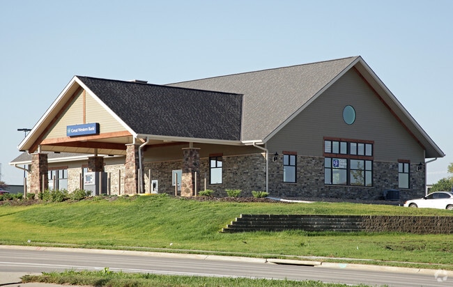
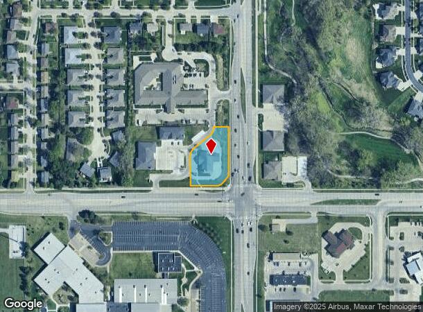
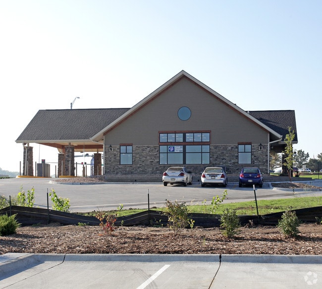
Property Record
8380 Old Cheney Rd, Lincoln, NE 68516
Current Lease Availabilities
NEARBY LISTINGS FOR SALE OR LEASE
Property Detail
8380 Old Cheney Rd
Lincoln, NE
Pine Garden 1St Addition
16-10-447-001-000
PINE GARDEN 1ST ADDITION, LOT 1
Officebuilding
Lancaster
X
Nebraska
31109C0338F
1
2024
0.78 AC
2025
Far South
003724
Lincoln
3,911 SF
DEMOGRAPHICS near 8380 Old Cheney Rd
1 Mile
3 Mile
5 Mile
2024 Total Population
9,924
55,341
134,311
2029 Population
10,278
57,319
139,235
Pop Growth 2024-2029
+ 3.57%
+ 3.57%
+ 3.67%
Average Age
42
41
41
2024 Total Households
3,779
22,760
55,627
HH Growth 2024-2029
+ 3.41%
+ 3.59%
+ 3.70%
Median Household Inc
$123,070
$89,552
$81,668
Avg Household Size
2.60
2.40
2.40
2024 Avg HH Vehicles
2.00
2.00
2.00
Median Home Value
$361,514
$297,432
$270,996
Median Year Built
2003
1992
1982
Nearby Places
- Restaurants
- Banks
- Shops
- Fitness
- Groceries
PUBLIC TRANSPORTATION
COMMUTER RAIL
Lincoln Amtrak Station (California Zephyr - Amtrak)
DRIVE
WALK
Distance
Lincoln Amtrak Station (California Zephyr - Amtrak)
18 min
9.2 mi
AIRPORT
Lincoln
DRIVE
WALK
Distance
Lincoln
24 min
13.9 mi
Freight Ports
Tulsa Port Of Catoosa
DRIVE
WALK
Distance
Tulsa Port Of Catoosa
459 min
385.5 mi
Nearby Properties
Address
Land Use
TOTAL SIZE
Lot Size
Zoning
Address
Land Use
TOTAL SIZE
Lot Size
Zoning
329,069 SF
30 AC
R6
Address
Land Use
TOTAL SIZE
Lot Size
Zoning
121,132 SF
12.54 AC
B5
Address
Land Use
TOTAL SIZE
Lot Size
Zoning
61,818 SF
12.38 AC
B5
Address
Land Use
TOTAL SIZE
Lot Size
Zoning
185,015 SF
38.72 AC
AGR
Address
Land Use
TOTAL SIZE
Lot Size
Zoning
17,070 SF
8.95 AC
R3
Address
Land Use
TOTAL SIZE
Lot Size
Zoning
24,771 SF
11.45 AC
R5
Address
Land Use
TOTAL SIZE
Lot Size
Zoning
131,316 SF
26.31 AC
R3
Address
Land Use
TOTAL SIZE
Lot Size
Zoning
65,640 SF
7.24 AC
B5
Address
Land Use
TOTAL SIZE
Lot Size
Zoning
142,179 SF
9.68 AC
R3
Address
Land Use
TOTAL SIZE
Lot Size
Zoning
90,362 SF
2.53 AC
B3
Address
Land Use
TOTAL SIZE
Lot Size
Zoning
57,434 SF
15.62 AC
R4
Address
Land Use
TOTAL SIZE
Lot Size
Zoning
148,760 SF
4.99 AC
R4
Address
Land Use
TOTAL SIZE
Lot Size
Zoning
32,443 SF
7.20 AC
NULL
Address
Land Use
TOTAL SIZE
Lot Size
Zoning
68,664 SF
7 AC
NULL
Address
Land Use
TOTAL SIZE
Lot Size
Zoning
39,968 SF
13.41 AC
NULL
Address
Land Use
TOTAL SIZE
Lot Size
Zoning
82,644 SF
18.57 AC
R3
Address
Land Use
TOTAL SIZE
Lot Size
Zoning
18,506 SF
12.61 AC
NULL
Address
Land Use
TOTAL SIZE
Lot Size
Zoning
67,029 SF
17.26 AC
R3
Address
Land Use
TOTAL SIZE
Lot Size
Zoning
86,718 SF
7.16 AC
NULL
Address
Land Use
TOTAL SIZE
Lot Size
Zoning
22,650 SF
5.59 AC
R3
Address
Land Use
TOTAL SIZE
Lot Size
Zoning
101,990 SF
5.38 AC
R4
Address
Land Use
TOTAL SIZE
Lot Size
Zoning
71,860 SF
13.19 AC
R3
Address
Land Use
TOTAL SIZE
Lot Size
Zoning
45,057 SF
37.07 AC
NULL
Address
Land Use
TOTAL SIZE
Lot Size
Zoning
100,452 SF
20.36 AC
AG
Address
Land Use
TOTAL SIZE
Lot Size
Zoning
76,130 SF
7.84 AC
NULL
Address
Land Use
TOTAL SIZE
Lot Size
Zoning
44,058 SF
4.35 AC
R4
Address
Land Use
TOTAL SIZE
Lot Size
Zoning
23,197 SF
9.57 AC
R4
Address
Land Use
TOTAL SIZE
Lot Size
Zoning
141,242 SF
5.73 AC
R3
Address
Land Use
TOTAL SIZE
Lot Size
Zoning
26,123 SF
5.62 AC
R3
Address
Land Use
TOTAL SIZE
Lot Size
Zoning
65,441 SF
2.93 AC
O3
The World's #1 Commercial Real Estate Marketplace
Connect with us
© 2025 CoStar Group
The information above has been obtained from sources believed reliable. While we do not doubt its accuracy we have not verified it and make no guarantee, warranty or representation about it. It is your responsibility to independently confirm its accuracy and completeness. Any projections, opinions, assumptions, or estimates used are for example only and do not represent the current or future performance of the property. The value of this transaction to you depends on tax and other factors which should be evaluated by your tax, financial, and legal advisors. You and your advisors should conduct a careful, independent investigation of the property to determine to your satisfaction the suitability of the property for your needs.