Property Record
839 Brushtown Rd, Cisco, GA 30708
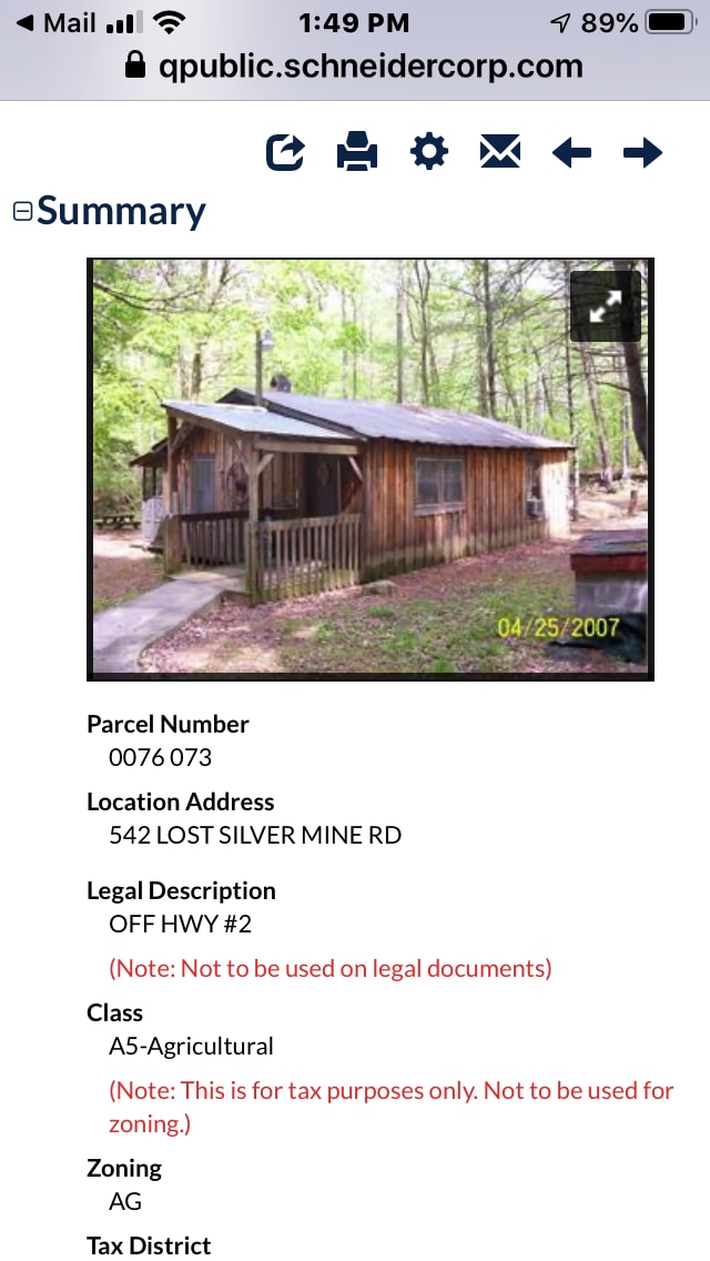

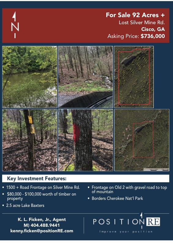
Property Detail
839 Brushtown Rd
0059-109
HWY 411 TR 159
Privatepreserveopenspacevacantlandforestlandconservation
MURRAY
AG
Georgia
B and X Area of moderate flood hazard, usually the area between the limits of the 100-year and 500-year floods.
79.20 AC
2025
Georgia Northwest
2025
Other Market Areas
010100
Dalton, GA
NEARBY LISTINGS FOR SALE OR LEASE
DEMOGRAPHICS near 839 Brushtown Rd
1 mile
3 mile
5 mile
2025 Total Population
119
1,096
3,155
2030 Population
128
1,167
3,318
Pop Growth 2025-2030
+ 7.56%
+ 6.48%
+ 5.17%
Average Age
42
42
42
2025 Total Households
45
418
1,226
HH Growth 2025-2030
+ 6.67%
+ 6.46%
+ 5.14%
Median Household Inc
$102,083
$76,087
$60,127
Avg Household Size
2.40
2.50
2.50
2025 Avg HH Vehicles
2.00
2.00
2.00
Median Home Value
$133,333
$153,149
$159,056
Median Year Built
1982
1983
1987
Nearby Places
Map Layers
Map Styles
 Street
 Aerial
Layers
 Traffic
 Biking
Places
Listings with unknown addresses are not visible on the map
- Restaurants
- Banks
- Shops
- Fitness
- Groceries
PUBLIC TRANSPORTATION
AIRPORT
Lovell Field
Drive
Walk
Distance
Lovell Field
58 min
40.1 mi
Freight Ports
Georgia Ports - Savannah
Drive
Walk
Distance
Georgia Ports - Savannah
405 min
346.2 mi
Nearby Properties
Address
Land Use
TOTAL SIZE
Lot Size
Zoning
Address
Land Use
TOTAL SIZE
Lot Size
Zoning
1,872 AC
AG
Address
Land Use
TOTAL SIZE
Lot Size
Zoning
1,658 AC
AG
Address
Land Use
TOTAL SIZE
Lot Size
Zoning
69.52 AC
SPLIT-ZONE
Address
Land Use
TOTAL SIZE
Lot Size
Zoning
275 AC
AG
Address
Land Use
TOTAL SIZE
Lot Size
Zoning
80,000 SF
49.08 AC
AG
Address
Land Use
TOTAL SIZE
Lot Size
Zoning
182.28 AC
SPLIT-ZONE
Address
Land Use
TOTAL SIZE
Lot Size
Zoning
7,642 SF
7.08 AC
SR
Address
Land Use
TOTAL SIZE
Lot Size
Zoning
245 AC
AG
Address
Land Use
TOTAL SIZE
Lot Size
Zoning
12,040 SF
1.67 AC
HC
Address
Land Use
TOTAL SIZE
Lot Size
Zoning
1,072 SF
32 AC
AG
Address
Land Use
TOTAL SIZE
Lot Size
Zoning
320 AC
AG
Address
Land Use
TOTAL SIZE
Lot Size
Zoning
1,800 SF
25.07 AC
SPLIT-ZONE
Address
Land Use
TOTAL SIZE
Lot Size
Zoning
6,288 SF
4.12 AC
RR
Address
Land Use
TOTAL SIZE
Lot Size
Zoning
82.24 AC
SPLIT-ZONE
Address
Land Use
TOTAL SIZE
Lot Size
Zoning
5,706 SF
5.56 AC
SR
Address
Land Use
TOTAL SIZE
Lot Size
Zoning
160 AC
AG
Address
Land Use
TOTAL SIZE
Lot Size
Zoning
189.37 AC
AG
Address
Land Use
TOTAL SIZE
Lot Size
Zoning
113 AC
AG
Address
Land Use
TOTAL SIZE
Lot Size
Zoning
211 AC
AG
Address
Land Use
TOTAL SIZE
Lot Size
Zoning
100.83 AC
AG
Address
Land Use
TOTAL SIZE
Lot Size
Zoning
3,072 SF
1.20 AC
MFR
Address
Land Use
TOTAL SIZE
Lot Size
Zoning
1,918 SF
67.67 AC
SPLIT-ZONE
Address
Land Use
TOTAL SIZE
Lot Size
Zoning
54.80 AC
SR
Address
Land Use
TOTAL SIZE
Lot Size
Zoning
2,520 SF
0.62 AC
SR
Address
Land Use
TOTAL SIZE
Lot Size
Zoning
102 AC
AG
Address
Land Use
TOTAL SIZE
Lot Size
Zoning
129 AC
AG
Address
Land Use
TOTAL SIZE
Lot Size
Zoning
88.04 AC
AG
Address
Land Use
TOTAL SIZE
Lot Size
Zoning
98.81 AC
AG
Address
Land Use
TOTAL SIZE
Lot Size
Zoning
78.20 AC
SPLIT-ZONE
Address
Land Use
TOTAL SIZE
Lot Size
Zoning
71.20 AC
AG
The World's #1 Commercial Real Estate Marketplace
Connect with us
© 2026 CoStar Group
The information above has been obtained from sources believed reliable. While we do not doubt its accuracy we have not verified it and make no guarantee, warranty or representation about it. It is your responsibility to independently confirm its accuracy and completeness. Any projections, opinions, assumptions, or estimates used are for example only and do not represent the current or future performance of the property. The value of this transaction to you depends on tax and other factors which should be evaluated by your tax, financial, and legal advisors. You and your advisors should conduct a careful, independent investigation of the property to determine to your satisfaction the suitability of the property for your needs.