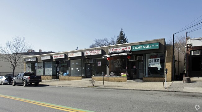
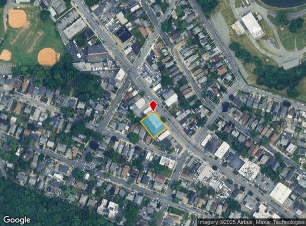
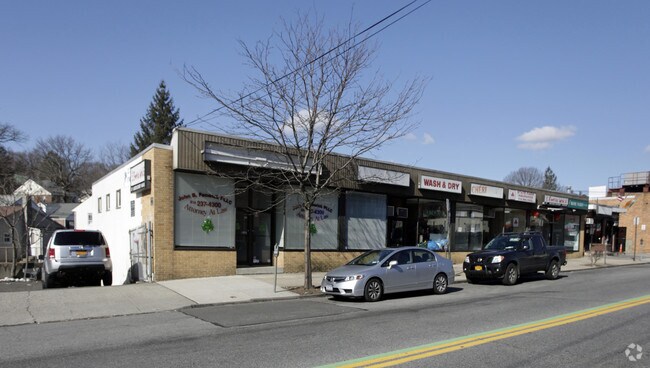
Property Record
839 Mclean Ave, Yonkers, NY 10704
NEARBY LISTINGS FOR SALE OR LEASE
Property Detail
839 Mclean Ave
1800-006-000-06229-000-0008
Estate Of David H King Jr
Storesoffices
Westchester
X
New York
36119C0338F
8.000
2025
0.28 AC
2024
Southwest
001503
Westchester/So Connecticut
5,000 SF
New York-Jersey City-White Plains, NY-NJ
DEMOGRAPHICS near 839 Mclean Ave
1 Mile
3 Mile
5 Mile
2024 Total Population
29,544
562,014
1,295,645
2029 Population
27,651
527,428
1,216,755
Pop Growth 2024-2029
(6.41%)
(6.15%)
(6.09%)
Average Age
41
39
39
2024 Total Households
11,721
208,095
474,415
HH Growth 2024-2029
(6.69%)
(6.52%)
(6.53%)
Median Household Inc
$84,660
$57,462
$56,002
Avg Household Size
2.40
2.60
2.60
2024 Avg HH Vehicles
1.00
1.00
1.00
Median Home Value
$508,198
$459,309
$506,896
Median Year Built
1949
1950
1950
Nearby Places
Map Layers
Map Styles
 Street
 Aerial
- Restaurants
- Banks
- Shops
- Fitness
- Groceries
PUBLIC TRANSPORTATION
TRANSIT/SUBWAY
Woodlawn (4 - New York MTA Subway (The Subway))
DRIVE
WALK
Distance
Woodlawn (4 - New York MTA Subway (The Subway))
6 min
11 min
0.6 mi
Nereid Avenue (2 - New York MTA Subway (The Subway), 5 - New York MTA Subway (The Subway))
DRIVE
WALK
Distance
Nereid Avenue (2 - New York MTA Subway (The Subway), 5 - New York MTA Subway (The Subway))
3 min
19 min
1.0 mi
COMMUTER RAIL
Wakefield Station (Harlem Line - Metro-North Commuter Railroad Company (Metro-North))
DRIVE
WALK
Distance
Wakefield Station (Harlem Line - Metro-North Commuter Railroad Company (Metro-North))
5 min
18 min
0.9 mi
Woodlawn Station (Harlem Line - Metro-North Commuter Railroad Company (Metro-North))
DRIVE
WALK
Distance
Woodlawn Station (Harlem Line - Metro-North Commuter Railroad Company (Metro-North))
3 min
19 min
1.0 mi
AIRPORT
LaGuardia
DRIVE
WALK
Distance
LaGuardia
20 min
14.6 mi
Westchester County
DRIVE
WALK
Distance
Westchester County
26 min
19.7 mi
John F Kennedy International
DRIVE
WALK
Distance
John F Kennedy International
32 min
22.5 mi
Freight Ports
NY - Red Hook Container Terminal
DRIVE
WALK
Distance
NY - Red Hook Container Terminal
1 min
16.8 mi
SALE & LEASE HISTORY
LISTING DATE
SALE/LEASE

Sep 25, 2016
For Lease
Nearby Properties
Address
Land Use
TOTAL SIZE
Lot Size
Zoning
Address
Land Use
TOTAL SIZE
Lot Size
Zoning
481,172 SF
205.58 AC
PARK
Address
Land Use
TOTAL SIZE
Lot Size
Zoning
1,132,500 SF
62.44 AC
R6
Address
Land Use
TOTAL SIZE
Lot Size
Zoning
895,256 SF
8.32 AC
R7-1
Address
Land Use
TOTAL SIZE
Lot Size
Zoning
1,237,424 SF
21.25 AC
R6
Address
Land Use
TOTAL SIZE
Lot Size
Zoning
70,737 SF
1.67 AC
BB
Address
Land Use
TOTAL SIZE
Lot Size
Zoning
204,200 SF
1.68 AC
R7-1
Address
Land Use
TOTAL SIZE
Lot Size
Zoning
4,000 SF
19.83 AC
BUS
Address
Land Use
TOTAL SIZE
Lot Size
Zoning
617,567 SF
3.19 AC
R7-1
Address
Land Use
TOTAL SIZE
Lot Size
Zoning
707,353 SF
29.34 AC
R6
Address
Land Use
TOTAL SIZE
Lot Size
Zoning
269,100 SF
1.63 AC
R4
Address
Land Use
TOTAL SIZE
Lot Size
Zoning
87,000 SF
455.70 AC
PARK
Address
Land Use
TOTAL SIZE
Lot Size
Zoning
450,784 SF
42.36 AC
R4
Address
Land Use
TOTAL SIZE
Lot Size
Zoning
18,445 SF
510.83 AC
PARK
Address
Land Use
TOTAL SIZE
Lot Size
Zoning
251,884 SF
21.53 AC
R6
Address
Land Use
TOTAL SIZE
Lot Size
Zoning
64,165 SF
3.24 AC
B
Address
Land Use
TOTAL SIZE
Lot Size
Zoning
1,028,976 SF
23.03 AC
R5
Address
Land Use
TOTAL SIZE
Lot Size
Zoning
614,887 SF
14.77 AC
R4
Address
Land Use
TOTAL SIZE
Lot Size
Zoning
1,038,034 SF
23.41 AC
R5
Address
Land Use
TOTAL SIZE
Lot Size
Zoning
244,650 SF
2 AC
R7-1
Address
Land Use
TOTAL SIZE
Lot Size
Zoning
280,539 SF
3.11 AC
R6
Address
Land Use
TOTAL SIZE
Lot Size
Zoning
61,055 SF
343.42 AC
R6
Address
Land Use
TOTAL SIZE
Lot Size
Zoning
285,373 SF
2.66 AC
R4
Address
Land Use
TOTAL SIZE
Lot Size
Zoning
493,000 SF
3.02 AC
R5
Address
Land Use
TOTAL SIZE
Lot Size
Zoning
203,837 SF
1.92 AC
R6
Address
Land Use
TOTAL SIZE
Lot Size
Zoning
453,364 SF
8.27 AC
R6
Address
Land Use
TOTAL SIZE
Lot Size
Zoning
193,520 SF
4.32 AC
R4
Address
Land Use
TOTAL SIZE
Lot Size
Zoning
240,000 SF
6.49 AC
C4-3
Address
Land Use
TOTAL SIZE
Lot Size
Zoning
633,000 SF
9.16 AC
R6
Address
Land Use
TOTAL SIZE
Lot Size
Zoning
Address
Land Use
TOTAL SIZE
Lot Size
Zoning
174,896 SF
8.69 AC
R4
The World's #1 Commercial Real Estate Marketplace
Connect with us
© 2025 CoStar Group
The information above has been obtained from sources believed reliable. While we do not doubt its accuracy we have not verified it and make no guarantee, warranty or representation about it. It is your responsibility to independently confirm its accuracy and completeness. Any projections, opinions, assumptions, or estimates used are for example only and do not represent the current or future performance of the property. The value of this transaction to you depends on tax and other factors which should be evaluated by your tax, financial, and legal advisors. You and your advisors should conduct a careful, independent investigation of the property to determine to your satisfaction the suitability of the property for your needs.