Property Record
8393 Rawsonville Rd, Belleville, MI 48111
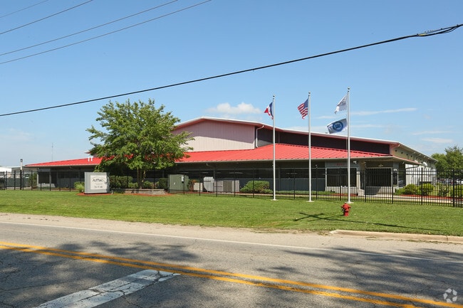


This Property Is For Sale
NEARBY LISTINGS FOR SALE OR LEASE
Property Detail
8393 Rawsonville Rd
Detroit-Warren-Dearborn, MI
South
81-022-99-0004-704
*06G2C2*PT OF THE NW 1/4 OF SEC 6 T4S R8E DESC AS BEG SOUTH 1916.52 FT FROM THE NW COR OF SEC 6--TH S 89D 31M 17S E 815.64 FT-TH S 51D 24M 04S W 634.53 FT-TH N 89D 31M 17S W 319.72 FT-TH NORTH 400.00 FT-POB. 5.21 AC--K-4.91
Manufacturinglight
Wayne
AE
Michigan
26161C0445E
0004
2025
4.91 AC
2025
Airport District
589401
Detroit
45,550 SF
DEMOGRAPHICS near 8393 Rawsonville Rd
1 Mile
3 Mile
5 Mile
2024 Total Population
1,319
18,889
60,188
2029 Population
1,342
18,723
59,059
Pop Growth 2024-2029
+ 1.74%
(0.88%)
(1.88%)
Average Age
44
40
40
2024 Total Households
530
7,279
24,341
HH Growth 2024-2029
+ 1.51%
(0.85%)
(1.97%)
Median Household Inc
$78,500
$71,859
$70,832
Avg Household Size
2.50
2.60
2.40
2024 Avg HH Vehicles
2.00
2.00
2.00
Median Home Value
$255,909
$224,617
$220,646
Median Year Built
1996
1992
1980
Nearby Places
Map Layers
Map Styles
 Street
 Aerial
- Restaurants
- Banks
- Shops
- Fitness
- Groceries
PUBLIC TRANSPORTATION
AIRPORT
Detroit Metro Wayne County
DRIVE
WALK
Distance
Detroit Metro Wayne County
18 min
15.8 mi
Freight Ports
Port of Baltimore
DRIVE
WALK
Distance
Port of Baltimore
1 min
415.2 mi
Nearby Properties
Address
Land Use
TOTAL SIZE
Lot Size
Zoning
Address
Land Use
TOTAL SIZE
Lot Size
Zoning
11,847 SF
91.35 AC
II
Address
Land Use
TOTAL SIZE
Lot Size
Zoning
97.69 AC
Address
Land Use
TOTAL SIZE
Lot Size
Zoning
1,960 SF
59.97 AC
Address
Land Use
TOTAL SIZE
Lot Size
Zoning
161,042 SF
26.29 AC
II
Address
Land Use
TOTAL SIZE
Lot Size
Zoning
2,700 SF
75.82 AC
Address
Land Use
TOTAL SIZE
Lot Size
Zoning
134,499 SF
6.20 AC
BA
Address
Land Use
TOTAL SIZE
Lot Size
Zoning
1,744 SF
41.75 AC
BI
Address
Land Use
TOTAL SIZE
Lot Size
Zoning
1,680 SF
20 AC
II
Address
Land Use
TOTAL SIZE
Lot Size
Zoning
54.32 AC
RMH MOB
Address
Land Use
TOTAL SIZE
Lot Size
Zoning
80.11 AC
Address
Land Use
TOTAL SIZE
Lot Size
Zoning
36,200 SF
15.23 AC
Address
Land Use
TOTAL SIZE
Lot Size
Zoning
4,442 SF
42.38 AC
RMH MOB
Address
Land Use
TOTAL SIZE
Lot Size
Zoning
6,000 SF
15 AC
DI
Address
Land Use
TOTAL SIZE
Lot Size
Zoning
35.89 AC
RMH MOB
Address
Land Use
TOTAL SIZE
Lot Size
Zoning
20 AC
DI
Address
Land Use
TOTAL SIZE
Lot Size
Zoning
8,580 SF
28.50 AC
Address
Land Use
TOTAL SIZE
Lot Size
Zoning
5,515 SF
89.67 AC
BLANK
Address
Land Use
TOTAL SIZE
Lot Size
Zoning
1.25 AC
Address
Land Use
TOTAL SIZE
Lot Size
Zoning
9,310 SF
38.46 AC
Address
Land Use
TOTAL SIZE
Lot Size
Zoning
8,000 SF
5.60 AC
Address
Land Use
TOTAL SIZE
Lot Size
Zoning
15,540 SF
52.16 AC
Address
Land Use
TOTAL SIZE
Lot Size
Zoning
29,656 SF
4.16 AC
C1 GEN
Address
Land Use
TOTAL SIZE
Lot Size
Zoning
12,720 SF
2.22 AC
BI
Address
Land Use
TOTAL SIZE
Lot Size
Zoning
11,052 SF
1.72 AC
C1 GEN
Address
Land Use
TOTAL SIZE
Lot Size
Zoning
12,000 SF
4.25 AC
II
Address
Land Use
TOTAL SIZE
Lot Size
Zoning
11,000 SF
35.61 AC
Address
Land Use
TOTAL SIZE
Lot Size
Zoning
Address
Land Use
TOTAL SIZE
Lot Size
Zoning
1,320 SF
29.19 AC
AG
Address
Land Use
TOTAL SIZE
Lot Size
Zoning
24,000 SF
4.92 AC
II
The World's #1 Commercial Real Estate Marketplace
Connect with us
© 2025 CoStar Group
The information above has been obtained from sources believed reliable. While we do not doubt its accuracy we have not verified it and make no guarantee, warranty or representation about it. It is your responsibility to independently confirm its accuracy and completeness. Any projections, opinions, assumptions, or estimates used are for example only and do not represent the current or future performance of the property. The value of this transaction to you depends on tax and other factors which should be evaluated by your tax, financial, and legal advisors. You and your advisors should conduct a careful, independent investigation of the property to determine to your satisfaction the suitability of the property for your needs.