Property Record
84 Ledbetter Rd, Villa Rica, GA 30180
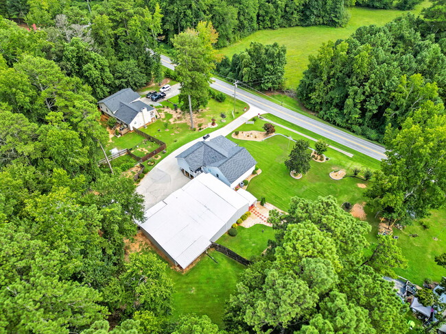
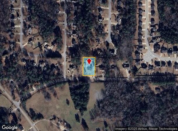

This Property Is For Sale
NEARBY LISTINGS FOR SALE OR LEASE
-
-
View all Villa Rica listings for sale on LoopNet.com
Property Detail
84 Ledbetter Rd
Atlanta-Sandy Springs-Roswell, GA
Ledbetter Trace -M167
167-0158
Carroll
Sfr
Georgia
X
0.61 AC
13045C0043D
I-20 W/Douglasville
2,137 SF
Atlanta
DEMOGRAPHICS near 84 Ledbetter Rd
1 Mile
3 Mile
5 Mile
2024 Total Population
3,137
18,362
42,077
2029 Population
3,405
19,878
45,449
Pop Growth 2024-2029
+ 8.54%
+ 8.26%
+ 8.01%
Average Age
38
37
37
2024 Total Households
1,121
6,447
14,707
HH Growth 2024-2029
+ 8.65%
+ 8.33%
+ 8.08%
Median Household Inc
$63,233
$85,396
$83,840
Avg Household Size
2.80
2.80
2.80
2024 Avg HH Vehicles
2.00
2.00
2.00
Median Home Value
$251,086
$277,572
$280,007
Median Year Built
2001
1998
2001
Nearby Places
Map Layers
Map Styles
 Street
 Aerial
- Restaurants
- Banks
- Shops
- Fitness
- Groceries
Nearby Properties
Address
Land Use
TOTAL SIZE
Lot Size
Zoning
Address
Land Use
TOTAL SIZE
Lot Size
Zoning
143,620 SF
12.14 AC
GC
Address
Land Use
TOTAL SIZE
Lot Size
Zoning
109,900 SF
54.59 AC
001
Address
Land Use
TOTAL SIZE
Lot Size
Zoning
54,539 SF
9.68 AC
R14
Address
Land Use
TOTAL SIZE
Lot Size
Zoning
26.74 AC
GI
Address
Land Use
TOTAL SIZE
Lot Size
Zoning
583,480 SF
46.54 AC
GI
Address
Land Use
TOTAL SIZE
Lot Size
Zoning
98,391 SF
6.66 AC
GC
Address
Land Use
TOTAL SIZE
Lot Size
Zoning
317,240 SF
30.08 AC
GI
Address
Land Use
TOTAL SIZE
Lot Size
Zoning
28,304 SF
13.83 AC
GC
Address
Land Use
TOTAL SIZE
Lot Size
Zoning
218,660 SF
39.19 AC
GI
Address
Land Use
TOTAL SIZE
Lot Size
Zoning
15,949 SF
9.01 AC
R14
Address
Land Use
TOTAL SIZE
Lot Size
Zoning
266,135 SF
25.58 AC
GI
Address
Land Use
TOTAL SIZE
Lot Size
Zoning
266,422 SF
16.35 AC
GI
Address
Land Use
TOTAL SIZE
Lot Size
Zoning
241,500 SF
21.13 AC
GI
Address
Land Use
TOTAL SIZE
Lot Size
Zoning
92,704 SF
40.02 AC
RD
Address
Land Use
TOTAL SIZE
Lot Size
Zoning
28,751 SF
6.40 AC
R14
Address
Land Use
TOTAL SIZE
Lot Size
Zoning
500 SF
5.89 AC
GI
Address
Land Use
TOTAL SIZE
Lot Size
Zoning
47,291 SF
19.48 AC
GC
Address
Land Use
TOTAL SIZE
Lot Size
Zoning
46.80 AC
Address
Land Use
TOTAL SIZE
Lot Size
Zoning
67,500 SF
20.77 AC
GI
Address
Land Use
TOTAL SIZE
Lot Size
Zoning
63,750 SF
21.30 AC
GI
Address
Land Use
TOTAL SIZE
Lot Size
Zoning
83,106 SF
7.70 AC
GI
Address
Land Use
TOTAL SIZE
Lot Size
Zoning
374,522 SF
22.37 AC
GI
Address
Land Use
TOTAL SIZE
Lot Size
Zoning
151,750 SF
9.30 AC
GI
Address
Land Use
TOTAL SIZE
Lot Size
Zoning
90,000 SF
12.12 AC
GI
Address
Land Use
TOTAL SIZE
Lot Size
Zoning
23.41 AC
GI
Address
Land Use
TOTAL SIZE
Lot Size
Zoning
29,165 SF
10.35 AC
R20
Address
Land Use
TOTAL SIZE
Lot Size
Zoning
9,158 SF
4.15 AC
DO-COM
Address
Land Use
TOTAL SIZE
Lot Size
Zoning
58,386 SF
7.05 AC
GC
Address
Land Use
TOTAL SIZE
Lot Size
Zoning
77,650 SF
8.78 AC
GC
Address
Land Use
TOTAL SIZE
Lot Size
Zoning
72,396 SF
44.06 AC
GI
The World's #1 Commercial Real Estate Marketplace
Connect with us
© 2025 CoStar Group
The information above has been obtained from sources believed reliable. While we do not doubt its accuracy we have not verified it and make no guarantee, warranty or representation about it. It is your responsibility to independently confirm its accuracy and completeness. Any projections, opinions, assumptions, or estimates used are for example only and do not represent the current or future performance of the property. The value of this transaction to you depends on tax and other factors which should be evaluated by your tax, financial, and legal advisors. You and your advisors should conduct a careful, independent investigation of the property to determine to your satisfaction the suitability of the property for your needs.